
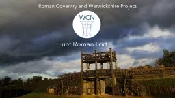
Lunt Roman Fort Lunt Roman Fort Baginton Lunt Roman Fort in Baginton was a Roman military camp created in around AD 60 or 61 possibly to deal with the revolt of Boudica andor its aftermath We have no record of the Lunt from Roman times or what it was called the name Lunt was introduced late ID: 933825
Download Presentation The PPT/PDF document "Roman Coventry and Warwickshire Project" is the property of its rightful owner. Permission is granted to download and print the materials on this web site for personal, non-commercial use only, and to display it on your personal computer provided you do not modify the materials and that you retain all copyright notices contained in the materials. By downloading content from our website, you accept the terms of this agreement.


Slide1
Roman Coventry and Warwickshire Project
Lunt Roman Fort
Slide2Lunt Roman Fort, Baginton
Lunt Roman Fort in Baginton was a Roman military camp created in around AD 60 or 61 possibly to deal with the revolt of Boudica and/or its aftermath.
We have no record of the Lunt from Roman times or what it was called - the name Lunt was introduced later and refers to trees or a wooded slope - so our knowledge comes entirely from archaeology and from how other similar sites were governed and worked.
Slide3The extent of the Fort and some of its features can be seen in this spectacular drone footage recorded in July 2021 thanks to Culture Coventry and fireFLY Aerial Innovation. The Romans here are re-enactors from the groups Britannia and The Vicus, alongside the Lunt's resident Romans Rufus and
Gnaeus (Richard and George).
Slide4The site of Lunt Roman Fort was identified when large quantities of Roman pottery were found in the 1930s during gravel-working in the village of
Baginton
.
In the 1960s, Brian Hobley, keeper of field archaeology at the Coventry Museum, started a long-term project to combine excavation with a study of the methods by which Roman camps were built.
Archaeological excavations identified four distinct periods of occupation of the Roman military site which will be discussed in the section on Development and History.
Slide5What do we mean by a Fort?
The terms
Fort
and
Fortress
refer to semi-permanent fortifications, forts being suitable for auxiliary forces of up to 1000, while fortresses could hold a legion of around 5500 troops.
As a fort, Lunt was never large enough to hold an entire legion, but would have been home to parts of legions or auxiliary forces. The longevity of these sites meant that they usually had some kind of associated settlement, commonly termed a
vicus
or
canabae
, the former referring to settlements outside forts and the latter outside a fortress.
However, as the Lunt was only in use for short periods over the history of Roman occupation in Britain, it is doubtful that there was anything much resembling a permanent settlement or
vicus
in or near Coventry.
Slide6Early forts in Roman Britain, like the Lunt, were constructed at great speed to secure recently occupied areas.
They were first built from turf and timber and were later rebuilt in stone when they needed to be renewed.
The
Lunt is unusual
in that it was never rebuilt in stone because it was only in use for a short period of time (see later).
Also, it was unusual because of its irregular plan. The Lunt is basically regular except for one of the long sides of the fort which skirts irregularly round what is thought to be a
gyrus
or horse-training facility.
Slide7Thus this odd shape fits the Lunt’s unique use, and makes it a
unique structure of the ancient Roman World
.
It seems hard to avoid the conclusion that this was a fort converted to fulfil a specialist function, seemingly, of horse training.
Other features found include four
granaries
and six
barrack blocks
, over 100
rubbish pits
and
water storage tanks
containing stratified artefacts, principally coins, pottery, glass, and military equipment.
Also, within the
sacellum (the small shrine inside the fort) an unusual pit-cellar was discovered, which had been built to store the garrison's pay chest.
Slide8Situation of the Fort
The fort sits on an ideal strategic site on a high plateau with a steep wooded slope overlooking the river Sowe to the north.
The elevation from the top of the bank provides good views of the landscape to the north for two or three miles (4.0 km) in the direction of modern Coventry. To the south is a flat plateau while to the east and west the ground slopes appreciably, making the site an ideal location for a Roman fort.
The Roman road now called the Fosse Way lies about 7 km to the south.
The site's defensive situation and its proximity to a crossing point in the river made it an ideal location. The river would have provided a source of fresh water and the Forest of Arden supplied timber for building.
Slide9Seen in a wider aspect (right), the river Sowe effectively forms a boundary along three sides of the site, with the land lying open only towards the east. The elevation from the top of the bank provides good views of the landscape to the north for two or three miles.
The reason for the location of the camp will be discussed later, but we have to assume that the location of the battle of Watling Street against Boudica in AD 61 must have lain nearby.
Whether the fort was first begun before or after the battle is not known, but that the
gyrus
was constructed to train the horses taken at the battle has been put forward as a possibility, suggesting that the battle could not have been too far away from the site at Baginton.
Slide10The Development and History of Lunt Fort
The evidence suggests an early acceptance of Roman rule in Warwickshire soon after the invasion of AD 43.
Yet the earliest evidence for occupation at the Lunt site has been dated to around the time of the Boudican rebellion in AD60 – AD61.
The Lunt is close to the junction of two major Roman roads, the Fosse Way and Watling Street and this whole area appears to have been a highly militarised zone with forts at Wall (Letocetum), Mancetter (Manduessedum), Alcester (Alauna) and Metchley.
Tacitus recorded that the whole army was kept mobilised during the winter to quell any remnants of the Boudican uprising
Slide11Slide12History of use of siteFour periods of occupation of the fort during periods of unrest in Roman Britain have been identified by excavation.
Period I: The fort was built around AD 60-61 to act as a supply depot and headquarters for an unknown legion or auxiliaries during or after the final campaign against Boudica.Period II: From ca.
AD 64 –77/78 it was used, in the second phase, by a legionary cohort in a reduced sized fort, from which the principia (central headquarters), praetorium, (dwelling place of the praetor or camp commander) two granaries and six barrack blocks have been excavated (see below). A number of buildings were demolished to construct a gyrus. Many horse fittings, possible stabling, an extensive metalworking area, granary and storage space suggests a cavalry unit was present at this time. This second phase lasted until AD 77/8.
Period III
: Developments in this phase (
AD 77/78-79)
included construction of a double ditch system, a twin-
portaled
gateway on the south and occupation outside the defences until the fort was decommissioned.
Period IV
: After
AD 260
it was recommissioned as a temporary fort with ditches on a similar alignment but slightly larger than that of Period II.
Slide13Period I (AD 60-64)
Excavations between 1968-71 revealed the presence of
barrack
-like buildings - part of a fort that was larger than any of the subsequent stages and for which the defences have not yet been located.
In addition to the barrack-blocks, a
granary
was located at the Northeast corner of the fort.
The original large camp of Period I seems to have had four building periods, all in timber, during the latest of which a large circular horse-training ring or
gyrus
was erected (right).
Slide14Period I: First Inhabitants
Who were the Romans who inhabited the camp?
Lunt Fort may have started-off life as a large encampment used to house a mixed regiment or two of cavalry and infantry known as a
cohors equitata
, together with an unknown number of horses captured during the campaigns against Boudica in AD 60-61.
Soldiers in this type of regiment would have been accustomed to the care and use of horses and would have been the logical choice to garrison the Fort, able to care for and train the horses they had captured.
Horses were then distributed to elite cavalry or as pack animals depending on their suitability.
Slide15Gyrus
or
Vivarium
The
gyrus
was a large circular structure on the east side of the fort, 34.06m in diameter with a funnelled entrance and double gate, probably indicating that the structure was used for livestock of some sort.
This feature is not only unparalleled in Britain, but is the only known example in the Roman Empire. It has been suggested that the
gyrus
was to be associated with the training of horses.
Slide16The
gyrus
was added to the fort at some point during the end of the first period and start of the second period of occupation, and its construction caused significant disruption to the fort.
Having the
gyrus
within affected not just the wall which curved to accommodate it, thus deviating from the standard Roman rectangular pattern, but also the layout of the fort was significantly different from the standard.
Slide17Evidence of Horses at Lunt
Archaeological excavations uncovered finds associated with cavalry within the fort, with
stable blocks
being uncovered from Period I.
This strongly suggests that the
gyrus
was once a cavalry-training arena where the soldiers stationed in the base trained horses for combat. The surface of the arena was kept smooth and level and was covered in sand.
The Greek historian Xenophon referred to such a structure as a
gyrus,
but there is no equivalent Latin word and we do not know what the Romans themselves called this type of structure - perhaps a
vivarium
or animal corral?
Slide18Period I: Boudica
Given the probable role played by the Lunt in stockading and training the horses taken from Boudica, we ought to imagine that the Lunt lay not too distant from the site of her defeat.
The large size of the camp suggests that it might have housed auxiliary troops on their way to quash the revolt.
If so the captured horses may then have been taken to what had been a temporary camp for soldiers on their way to fight, if the fort was not itself constructed afterwards.
It is possible a Legion like the XX, housed at that time in Glevum (Gloucester), were moved up towards Watling Street along the Fosse Way and temporarily housed near the cross point of the two roads.
Slide19The evidence for the presence of the XX legion at the fort, either before or after Boudica’s defeat, might be suggested in a silver ring unearthed at the site during excavation (right).
The ring with a palm leaf engraved on the face has been taken to suggest the presence at the fort of a winning gladiator – as the palm leaf as a symbol of victory was sometimes worn by such men…
Slide20But a closer look at the ring reveals something more remarkable – the possible engraving of XX, one X either side of the palm. Could this ring have belonged to a soldier from the XX Legion?
It is also known that the XX were given the honorary title of
Legio vigesima Valeria Victrix
.
Some suggest that the title was earned defeating Boudica, others that they were given the title earlier (AD 6-9) for their part in quelling a revolt in Illyria (modern Albania). Either way, the palm as symbol of victory might be a symbol for Valeria Victrix.
Slide21If the Fort had been mainly occupied with the holding and training of the captured horses, then following the initial large number of animals the supply would soon have petered out.
After this a large military presence at the site would be no longer required. The original large defences were therefore levelled, and the much-smaller
Period II
fort was built within the first camp.
Slide22Period II (ca. AD64-77/78)
In AD64 the fort was reduced in size (to approximately 300 x 550 ft - 91 x 165 m) and assumed its characteristically odd shape.
For while the north, south and west sides followed the usual pattern for a Roman camp of straight ditches and ramparts, on the eastern side the defences bulged out around the 32m diameter
gyrus
.
The fort was contacted on all sides save the north, where the natural slope gave excellent protection. This turf and timber fort had most of its interior buildings rebuilt in stone, aside from the three timber-built granaries and the
gyrus
, which now lay in the central area of the new fort adjacent to the eastern defences.
It is the defences and interior buildings of this period that are on display at the modern site.
Slide23Towards the end of the AD 70s the number of barrack blocks at the fort was also reduced.
This may have been due to an uprising by the Silurians, a tribe in south Wales, and the need for soldiers to be stationed within easy reach of any trouble.
Based on the number of barrack blocks, it has been estimated that there were approximately
480 foot soldiers
and
120 cavalry soldiers
here during this period.
Slide24The Granary – AD64-78
The rebuilt Granary (left) houses the Lunt’s museum.
Granaries were an important feature of all Roman forts as they not only housed the grain for the troops, but also stored valuable equipment. The present reconstructed granary follows the Roman pattern in storing a number of valuable items from the Lunt's Roman past including the silver ring.
Each fort was supposed to hold a year's supply of food in case they fell under siege.
The granary buildings were usually situated in the centre of Roman forts as far as possible from the reach of attackers’ fire arrows.
Granaries were raised off the ground in order to keep grain damp free and to allow air to circulate easily. The granary at the Lunt was sited to the west of the Principia, and dates to between AD 64 and AD 78. It was built on top of a structure that has been identified as the commanding officers house (praetorium).
Slide25Period III (ca. AD 77/78-79)
The third period of the life of the fort included construction of a double ditch system, a twin-
portalled
gateway on the south, and occupation outside the defences until the fort was decommissioned.
The fort was shortened during this period, reduced to approximately 91 x 113 m. This was achieved by abandoning the area to the south of the Period II
via principalis
and building a rampart along the southern edge of this road; the gyrus - as would be expected - and other internal buildings to the north of the road were retained.
The third period fort was then abandoned after a relatively short period of use, perhaps because following Boudica’s revolt, the West Midlands tribes developed good relations with their Roman overseers.
Slide26The fort of Period III likely represents further scaling-down of operations at the fort which continued to operate with a reduced garrison for a short time before the defences were finally demolished and the site abandoned.
Its garrison were possibly withdrawn for use in the northern campaigns of Agricola who in AD79 became governor of Britain.
The fort was finally abandoned around AD80.
Slide27Defences
As recorded by the official Lunt Fort website, all Roman forts employed a variety of defensive structures and methods, and the Lunt had a V-shaped ditch surrounding the whole fort.
Roman ditches did not contain water, like later castle moats, but the bottoms of these ditches were flat so they could be scraped clean and could contain wooden stakes and caltrops (metal spikes).
Narrow channels could also be used to drain the ditches and to serve as 'ankle breakers' to catch the feet of attackers.
Slide28Period IV (ca. AD 260)
After AD 260 the Lunt was recommissioned as a temporary fort with ditches on a similar alignment but slightly larger than that of Period II, though the fort itself was smaller – around 91 x 165 m.
No interior buildings dating to this period have been found, which probably indicates that occupation did not last long, the troops perhaps living in field conditions in tented accommodation.
Evidence for the dating of this occupation period is a single coin found in the post hole of a gateway minted under the emperor Gallienus (ruled AD 260-280). But there is no other evidence of occupation so the coin could have been a casual loss long after the fort had been abandoned.
Slide29Lunt Fort Finds
The Lunt is also remarkable for the exotic items found there.
One of the most astonishing is the plain
black colour-coated bowl
(left) with a central finial, from the post-Boudican fort at the Lunt, for which there are two known parallels, one in Gaul and the other in Spain.
This exceptional object is of eggshell thinness and polished to a fine lustre, and its central pedestal or finial in the interior is a feature which could be a copy of a finial on late Hellenistic silver vessels from Italy.
Slide30As discussed earlier, this ring may present evidence of members of the XX legion at the fort, either before or after Boudica’s defeat.
The ring with a palm leaf engraved on the face has been taken to suggest the presence at the fort of a winning gladiator – as the palm leaf as a symbol of victory was sometimes worn by such men.
But the possible engraving of XX, one X either side of the palm, may suggest that this ring belonged to a legionnaire from the XX Legion.
Slide31Margaret Rylatt MBE and the rebuilding of Lunt Fort
What makes Lunt Roman Fort such a special place to visit - aside from the knowledge of its uniqueness of its structure and gyrus - is the wonderful reconstruction of the granary,
gyrus
and gateway that really brings the site to life.
The reconstruction was overseen in the late 1960s and early 1970s by the archaeologist Margaret Rylatt MBE (seen in the photo above standing on the far right with a group of her students), using the same tools and techniques that the military engineers of the Roman Army would have used.
Slide32Margaret persuaded the Royal Engineers Army Team to build the replica Roman military buildings and defences at the Lunt Fort.
By challenging the soldiers to do what arguably the greatest army in history did 2,000 years ago with limited resources, it was a challenge they could not refuse.
They first built ditches, then the ramparts, wooden fences and a grand entrance gate that is now the most recognised feature of the Lunt. These features of the fort were reconstructed upon the original foundations, including a section of the wall, a gateway, one of the three granaries and the
gyrus
.
Slide33With no evidence of the look of the gateway, other than the clues given by its archaeological footprint, it was decided to model the fort on images found on Trajan's column (above right).
Slide34Each year the Army would come back and build something else, such as the Granary which houses the Museum and interpretation centre.
Slide35Visit Lunt Fort
Lunt Roman Fort is in Baginton on the outskirts of Coventry, so why not come along and pay a visit?
Why not see if you can arrange a school trip to the site, or take part in online events with the Lunt’s resident Romans?
Find out more about Lunt Fort at www.luntromanfort.org