
Opportunities and Challenges Topic Topographic measures mapping visualization Geographic Information Systems Earth Science Literacy Initiative ESLI 2009 Earth scientists are continually improving estimates of when and where natural ID: 930385
Download Presentation The PPT/PDF document "LiDAR and Geoscience Education" is the property of its rightful owner. Permission is granted to download and print the materials on this web site for personal, non-commercial use only, and to display it on your personal computer provided you do not modify the materials and that you retain all copyright notices contained in the materials. By downloading content from our website, you accept the terms of this agreement.


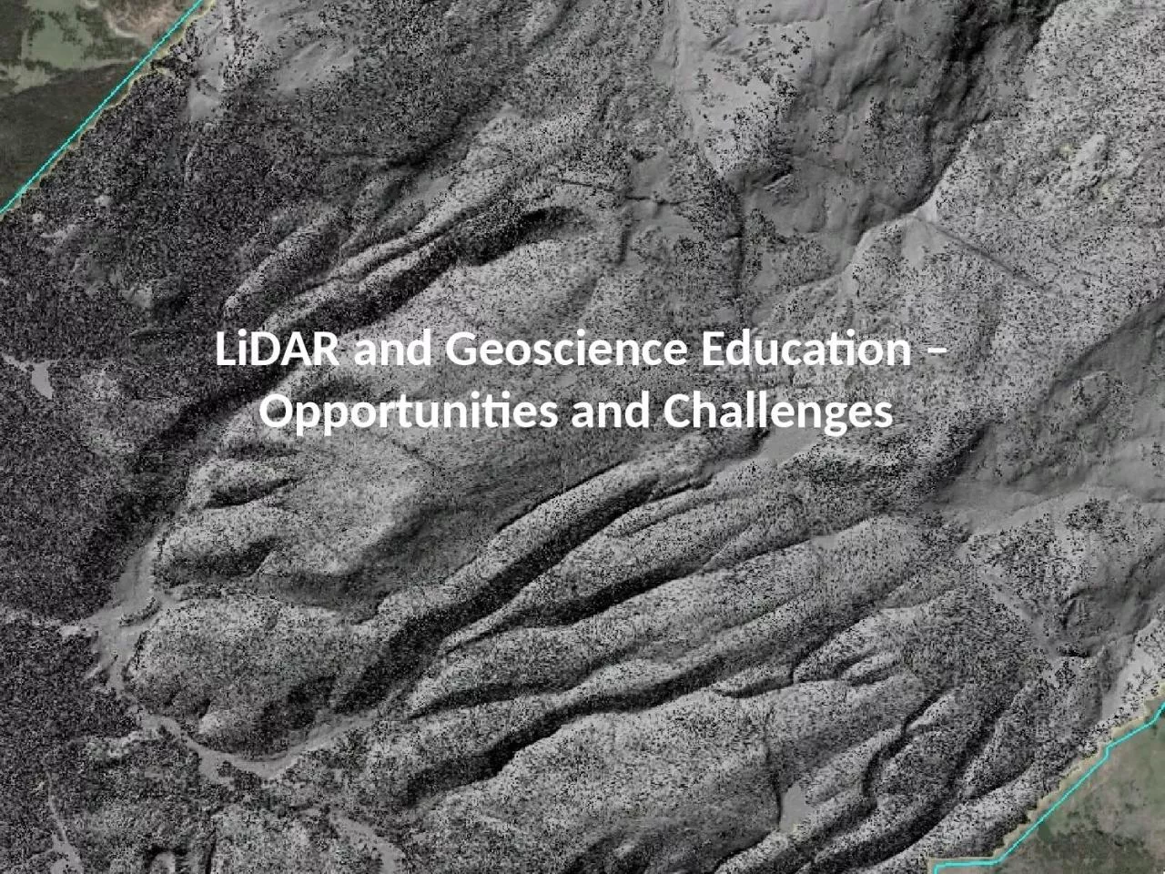
Slide1
LiDAR and
Geoscience
Education
–
Opportunities
and
Challenges
Slide2Topic
Topographic measures, mapping, visualization,
Geographic Information Systems
Earth Science
Literacy Initiative
(ESLI, 2009
Earth scientists are continually improving estimates of when and where natural
hazards occur
An Earth-science literate
public is essential for reducing risks from natural hazards
Benchmarks for
Science Literacy
(AAAS, 1993)
Use computers to store and retrieve information and create files (Grades 6-8);
Use computers to produce [graphics] and make calculations (Grades 9-12).
National Science Education
Content Standards
(NRC, 1996)
Use appropriate tools and techniques to gather, analyze, and interpret data; Develop descriptions, explanations, predictions, and models using evidence; Think critically and
logically (Grades 5-8); Design and conduct scientific investigations; Use technology to improve investigations; Scientists rely on technology to enhance gathering and manipulation of data (Grades 9-12).
Content in exemplary
Introductory
geoscience
textbooks
Trend toward maps and remotely sensed imagery of landforms as examples.
• Fundamental
importance of topography and challenge of teaching its representation by contours,
hillshades
, profiles.
• Spatial data
integration as part of inquiry-based learning.
Marshak
(2008) notably introduced “
Geotours
” which are guided explorations of a given topic via Google Earth.
Slide3Topic
Earth as a system of which humans are a significant part
Earth Science
Literacy Initiative
(ESLI, 2009
• Humans have become a significant agent of change on Earth
• Humans are the most significant agents of change in
surficial
Earth
Processes
Benchmarks for
Science Literacy
(AAAS, 1993)
Processes that Shape the Earth: Human activities have changed the
Earth’s [surface] (Grades 6-8).
National Science Education
Content Standards
(NRC, 1996)
•
Living organisms have played many roles in the Earth system (Grades 5-8).
•Human
activities can induce hazards; Hazards present the need to
assess potential danger and risk; Risk analysis estimates
[who] might suffer consequences (Grades 9-12).
Content in exemplary
Introductory
geoscience
textbooks
Appreciation of effects of alteration of surface processes by humans; Importance of knowledge of earth science for sustainability.
Slide4Topic
Geometry and processes of fluvial systems and
hillslopes
Earth Science
Literacy Initiative
(ESLI, 2009
• Earth is the water planet
• Water shapes landscapes
Benchmarks for
Science Literacy
(AAAS, 1993)
• Processes that Shape the Earth: [Surface processes] shape and reshape the earth’s land surface (Grades 3-5); Surface changes can be abrupt or slow; The surface is shaped by the motion of water and
wind (Grades 6-8).
National Science Education
Content Standards
(NRC, 1996)
Landforms are the result of a combination of constructive and destructive forces; Water circulates through crust, oceans, and atmosphere; Water is a solvent (Grades 5-
8).
Content in exemplary
Introductory
geoscience
textbooks
Various levels of description and process discussion for terrestrial
landforms illustrated via cartoons and actual examples from maps, imagery, and photography.
Slide5Topic
Manifestation of plate tectonics along faults at and near plate boundaries, earthquake cycle, earthquakes recorded in landscape
Earth Science
Literacy Initiative
(ESLI, 2009
• Earth is a continuously changing planet
• Many active and energetic geologic processes occur at plate boundaries
• Humans are threatened by Earth’s natural hazards
Benchmarks for
Science Literacy
(AAAS, 1993)
• Processes that Shape the Earth: Plates ride on a deformable layer (Grades 9-12).
•Moving the Continents: The theory of plate tectonics provides an explanation for diverse phenomena (Grades 9-12).
•
Earthquakes often occur along the boundaries between colliding plates (Grades 9-12)
National Science Education
Content Standards
(NRC, 1996)
Lithospheric
plates move at rates of centimeters per year;
Major geological events result (Grades 5-8); Heat transfer
and resulting convection propel the plates (Grades 9-12).
Content in exemplary
Introductory
geoscience
textbooks
• The San Andreas fault as an on land example of a transform fault.
• Other faults as part of larger system of deformation.
Slide6Data exploration activity
Go to
http://opentopography.org/kml
Download
NoCal
,
SoCal
and ISB KMZ files
Goal: locate features depicted in LiDAR images that could be used to illustrate the earth science topics / literacy goals outlined.
Slide7FIND (one or two examples):
Earth as a system of which humans are a significant part:
Human induced landscape change
Roadcuts
, developments, agriculture,
Humans living in areas of high hazard
Humans attempting to control nature / hazards
Geometry and processes of fluvial systems and
hillslopes
:
Hillslope
processes in action (landslides etc.)
Temperate fluvial system
Desert fluvial system
Differences?
Manifestation of plate tectonics along faults at and near plate boundaries, earthquake cycle, earthquakes recorded in landscape:
Find a fault
How do you know?
Type of offset?