
Seungbum Kim Science Question How to simulate Lband SAR data over natural terrain like shrublands Data amp Results Shrublands in California were imaged 17 times from 2010 until 2014 by ID: 777620
Download The PPT/PDF document "L-band SAR modeling on shrublands" is the property of its rightful owner. Permission is granted to download and print the materials on this web site for personal, non-commercial use only, and to display it on your personal computer provided you do not modify the materials and that you retain all copyright notices contained in the materials. By downloading content from our website, you accept the terms of this agreement.


Slide1
L-band SAR modeling on shrublandsSeungbum Kim
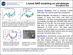
Science Question: How to simulate L-band SAR data over natural terrain like shrublands? Data & Results: Shrublands in California were imaged 17 times from 2010 until 2014 by UAVSAR at 1.26 GHz. A physically-based model successfully simulated the UAVSAR data with a difference of <0.9 dB. The time-series inversion was able to retrieve soil moisture with the difference of 0.025 m3/m3. The plant water content was formulated as a function of plant’s dielectric property (water fraction) while the plant geometry remained static in time. Significance: Shrublands occupy about 20% of the global landcover, and represent biomass with little temporal changes in size but large variations in plant water content. The proposed modeling approach may significantly improve the simulation of data and soil moisture retrieval.
S. Kim, M. Arii, T. Jackson, Modeling L-band synthetic aperture radar data through dielectric changes in soil moisture and vegetation over shrublands, J. Selected Topics Applied Earth Obs. Remote Sensing, DOI: 10.1109/JSTARS.2017.2741497, 2017This work was supported by NASA under the SUSMAP project (Prog. Mgr. Jared Entin)
Comparison of σ0 between model and UAVSAR. Plant water content is controlled (a) by the geometry of a growing plant or (b) by the seasonal change in dielectric property (mainly in leaf water fraction). Abscissa is day of each year
National Aeronautics and Space Administration
Jet Propulsion Laboratory
California Institute of Technology
Retrieval of change index and absolute soil moisture through the forward model inversion.
UAVSAR HH σ
0
(+ marks define the study domain of 1 x 0.25 km).