
All hiking times and distances are roundtrip unless otherwise indicated For your safety always carry the 10 Essentials a topographic map compass extra food extra clothingrain gear emergenc ID: 439906
Download Pdf The PPT/PDF document "Sunrise Area Trails" is the property of its rightful owner. Permission is granted to download and print the materials on this web site for personal, non-commercial use only, and to display it on your personal computer provided you do not modify the materials and that you retain all copyright notices contained in the materials. By downloading content from our website, you accept the terms of this agreement.

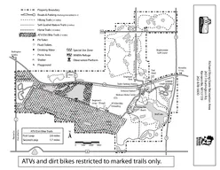


Sunrise Area Trails All hiking times and distances are round-trip, unless otherwise indicated. For your safety, always carry the 10 Essentials: a topographic map, compass, extra food, extra clothing/rain gear, emergency shelter, rst aid kit, ashlight and extra batteries, sunglasses and sunscreen, pocketknife, and matches (for emergency use only— res are not allowed in Mount Rainier’s Wilderness). 8/11 Mount Rainier National Park National Park Service U.S. Department of the Interior Easy Trails Sunrise Nature Trail 1.5 miles. 300' elevation gain. Average hiking time: 45 minutes. The trailhead is at the upper end of the picnic area. Self-guiding loop with views of Mount Rainier and the Cascades. Silver Forest Trail 2 miles. 150' elevation gain. Average hiking time: 1 hour. The trailhead is located south of the parking lot. Follow the Sunrise Rim Trail, then head east on the Silver Emmons Vista Overlooks (0.5 mile one way), continues through an old burn area. Moderate Trails Sourdough Ridge Trail: (West to Frozen Lake) 3 miles. 500' elevation gain. Average hiking time: 1.5 hours. Follow the nature trail to the left, then head west on the Sourdough Ridge Trail. Return to Sunrise via the Wonderland Trail and the old Campground Trail. Fragile vegetation in Frozen Lake area: Please Stay On The Trail! (East to Dege Peak) 4.2 miles. 800' elevation gain. Average hiking time: 2.5 hours. Follow the nature trail to the right, then head east on the Sourdough Ridge Trail to the Dege Peak spur trail. Emmons Moraine Trail 3 miles, 700' elevation gain. Average hiking time: 3 hours. Begins in “D” loop of the White River Campground. Follow the Glacier Basin Trail for one mile; take the left fork and hike along the moraine. Strenuous Trails Sunrise Rim Trail 5.2 miles. 1000' elevation gain. Average hiking time 3 hours. Follow the Sunrise Rim Trail to Shadow Lake continuing to Glacier Overlook and 1 st Burroughs Mountain. Burroughs Mountain Trail (1 Burroughs Mtn.) 4.8 miles. 900' elevation gain. Average hiking time: 3 hours. (2 nd Burroughs Mtn.) 6.0 miles. 1200' elevation gain. Average hiking time: 4 hours. Start at the upper end of the picnic area. Follow the Sourdough Ridge Trail to the junction at Frozen Lake, then climb up the Burroughs Mtn. Trail. Return via the Sunrise Rim Trail. Caution: Hazardous travel on icy slopes until late in the season! Mount Fremont Lookout Trail 5.6 miles. 900' elevation gain. Average hiking time: 3.5 hours. Follow the Sourdough Ridge Trail to the junction at Frozen Lake, then take the Mount Fremont Trail to the old re lookout. Upper Palisades Lake Trail 7 miles. 1800' elevation gain. Average hiking time: 5 hours. Begins at Sunrise Point. Follow the Palisades Lake Trail past Clover Lake to Upper Palisades Lake. No views of Mount Rainier. Glacier Basin Trail 6.5 miles. 1700' elevation gain. Average hiking time: 6 hours. Begins in “D” loop of the White River Campground. Berkeley Park 7 miles. 1200' elevation gain. Average hiking time: 5 hours. Take the Sourdough Ridge Trail to the junction at Frozen Lake, then follow a section of the Northern Loop Trail down into Berkeley Park. Pets & bicycles are prohibited on park trails .72.2.6.7.71.51.3.6.4.81.31.9.3.5.5.31.21.2.82.6.5.8.51.01.4.7SunriseWhite RiverCampground Glacier Basin Camp6000'Silver ForestTrailEmmonsVitaGlacierlookSunrise CampFrozen Lae Fist BuroughsScond Buroughs7400'7000'Berkeley ParkCamp5380'Foest Lae5653'Mt. Fremont7181' Mt remont7200' Syscaper Mtn.7078' Goat sland Mtn.7288'H u c k l e b e r r y C r e e k H u c k l e b e r r y B a s i n B u r r o u g h s M t n s. B e r k e l e y P a r kG r e e n P a r kW h i t eSunrie Lae Dege eak7006'5738'Clover Lae5751'Hidden Lae5922'Upper aiads Lae5853'Lower aiadsLae5505'Dick LakeUpper PalisadesLake CampSunriePointForest LakeW h i t e R i v e r S o u r d o u g h R i d g e6400'4232'Wonderland railTo Summerland 4.1 o OwyhighLake White RiverEntranceHw. 410MysticLae ToGrand Sunrise Aea rails MOUNT RAINIER NTIONAL ARKPROTECT THE MEADOWS! Carry the "10 Essentials" andLeave No race of your visit.Pets are NOT allowed on trails.Do not feed or approach wildlife.Use a topographic map.Permit required for Wilderness camping. Road TrailWilderness Camp Campground Wonderland rail Emmons Moraine rail 8/111.5.9.5 Shadowe 01/21MILES Trail onditions an chang. lways check tail onditions efoe hiin. 2.6 Pass