
Be able to describe the formation of a depression weather system Objectives Be able to describe the air movement within a depression weather system Be able to identify the features of a depression upon a satellite image ID: 261622
Download Presentation The PPT/PDF document "Formation of a depression" is the property of its rightful owner. Permission is granted to download and print the materials on this web site for personal, non-commercial use only, and to display it on your personal computer provided you do not modify the materials and that you retain all copyright notices contained in the materials. By downloading content from our website, you accept the terms of this agreement.


Slide1
Formation of a depressionSlide2
Be able to describe the formation of a depression weather system.
Objectives
Be able to describe the air movement within a depression weather system.
Be able to identify the features of a depression upon a satellite image.
Be able to identify the features of a depression upon a synoptic weather chart. Slide3
Polar Front
Cold artic or polar air
Tropical air
Somewhere over the Atlantic…
Depressions form at the boundary between cold artic/polar air in the North and tropical air in the South.Slide4
Cold artic or polar air
Tropical air
The cold air is pushing south and the warm air is pushing north, this creates a bulge along the polar front.Slide5
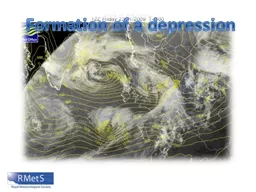
Can you identify the bulge along the polar front signifying the start of a depression?Slide6
Cold artic or polar air
Tropical air
Due to the Coriolis Effect, caused by the rotation of the Earth, the air moves around an area of low pressure in an anti-clockwise direction. Slide7
Cold artic or polar air
Tropical air
We can now see three fronts within the depression.
Cold Front
Warm Front
Occluded frontSlide8
Identifying a depression on a synoptic chart. Can you identify?
Areas of low pressure
Isobars tightly packed
Characteristic fronts, warm, cold and occludedSlide9
In order to be sustained, depressions need a source of warm moist air. This is provided by the warm conveyor.
Warm conveyor
This rises rapidly over the cold air in front of it.
As it does, the moisture within it cools and condenses to form a characteristic area of clouds.
The cloud edge is sharp along the cold front.
Like humans, depressions are both born and mature over time…Slide10
Can you identify the warm conveyor on this satellite image?Slide11Slide12
A ‘cold conveyor’ bring cold air in along the warm front, which rapidly rises in the centre of the system.
This forms a characteristic band of cloud and precipitation as air rises towards the centre of the depression. This is called the emerging cloud head.
cold conveyorSlide13
This encourages the warm air along the warm conveyor to rise.
Behind the cold front, cold air descends from the upper atmosphere and spreads out along the cold front. Slide14
Can you identify the emerging cloud head on this satellite image?Slide15Slide16
Over time the depression begins to decay, the cold air cuts off the supply of warm moist air- leaving the emerging head cloud along the cold conveyor.Slide17
Can you identify the cloud associated with the decaying depression on this satellite image?Slide18Slide19
Movement of depression Klaus…
http://www.youtube.com/watch?v=K_9ciOB8Ot0Slide20
Depression or not?…
Which of the following would you associate with a depression?
Statement
True
False
Depressions begin when
two types of cold air meet.
Depressions
are associated with low pressure.
The
air moves in a clockwise direction within a depression.
Depressions usually
bring rainfall.
In a depression
we could expect to see isobars packed closely together.
There
is usually no wind in a depression.