
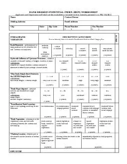
Mailing Address Email Address City State Zip Code Phone Number STREAMBANK Hydraulic Influence of Upstream Structures ID: 849995
Download Pdf The PPT/PDF document "BANK EROSION POTENTIAL Applicants and De..." is the property of its rightful owner. Permission is granted to download and print the materials on this web site for personal, non-commercial use only, and to display it on your personal computer provided you do not modify the materials and that you retain all copyright notices contained in the materials. By downloading content from our website, you accept the terms of this agreement.


1 BANK EROSION POTENTIAL Applicants and De
BANK EROSION POTENTIAL Applicants and Department staff shall use this worksheet to calculate erosion intensity pursuant to ss. NR 328.38(2) Name Contact Person Mailing Address Email Address City State Zip Code Phone Number ( ) ( ) STREAMBANK Hydraulic Influence of Upstream Structures distance (number of channel widths) to bridges, culverts, or dams. Number of Channel Widths= Stream Distance to Structure Divided by the Average Channel Width 10+ channel channel Bank Slope (degrees) - measure rise/run and translate into angle Inverse Tangent (Rise/Run) Very Low Vertical abundance of the vegetation, roots, and tree-falls occurring between the OHWM and the bank lip. bank unable to vegetation. Dense vegetation e soil 30-59% bare soil visible Sparse vegetation 60-90% bare soil visible 0% ;ºr6;&#x.900;90% bare soil Thalweg means the deepest part of the channel or the location of fastest current. To find the thalweg, the channel must be divided into thirds. The applicant needs to perform one or a mixture of tests for the three segments in determining its location. The following tests are suggested: float an object such as an orange peel down the stream to find the segment of fastest current, find the segment with the bubble line visible at the waters surface, or find the deepest part of the channel,safe. After locating the thalweg, record its proximity to the tested bank, adjacent (closest), center, or opposite (furthest) and record its associated point value. ThalwegThalwegThalweg Assessed BankLocation: OppositeLocation: AdjacentLocation: Center 1/31/3 1/31/31/31/31/31/3Assessed BankAssessed Bank ***When the Department or applicants assess erosion at the bank stabilization site they shall apply methods outlined in the BEPI Worksheet above to calculate a bank erosion potential index (BEPI) score. For each continuous treatment site of 300 feet or less, applicants shall submit at least one BEPI assessment. For continuous treatments greater than 300 feet applicants shall conduct and submit BEPI assessments at 150 foot intervals along the treatment site. Note: The BEPI Worksheet is adapted from Rosgen, David L. “A Practical Method of Computing Streambank Erosion Rate”, Wildland Hydrology Inc., Pagosa Springs, CO, 10 pp. Ordinary High Water Mark (OHWM) means the point on the bank or shore up to which the presence and action of water is so continuous as to leave a distinct mark either by erosion, destruction of terrestrial vegetation or other easily recognizablecharacteristics. If bank material is composed of bedrock outcrop, stop with the BEPI assessment at this point; the reported total BEPI score is assumed equal to 0. Maximum bank height means the vertical measure (feet) from the bank toe to the top of the bank lip, irrespective of changes in the water level. Bank toe is the inflection or bending point between the bank face and stream bed. To measure the bank slope (degrees), the rise and run must be measured from the bank toe to the top of the bank lip. With your measure tape or stick, place the end firmly on the bank toe, parallel to the bank face and measure up to the bank lip to find the rise or max bank height. Subsequently, measure the run from the bank toe to the bank lip. From these measures, one should be able to calculate the bank slope with the formula ‘bank slope= inverse tangent (rise/run)’. AdditionaBEPI Calculator available on the Department’s website ttp://dnr.wi.gov/ .h&#x h-4;tml. This website automaticallycalculates the bank slope and BEPI score after inputting fields for bank materials, structures upstream, OHWM height, max bank height, distance to bank face, bank layering/stratification, bank vegetation, and thalweg location. Bank LipMax Bank Height Terrestrial Vegetation Ordinary High Water Mark (OHWM)RiseThalweg (Inflection Stream Bed Bank Stratification or bank layering means soils consisting of alternating layers of varying soils or textures. Bank vegetation is the type and abundance of vegetation occurring between the ordinary high water mark (OHWM) and the bank lip. To assess the abundance of vegetation on the targeted bank, apply a 10 foot wide window of assessment from the OHWM to the top of the bank. The following percentages are assigned for the categories: bare soil visible over less than 30% of the surface area=dense vegetation; bare soil visible across 30-59% of the surface area= clumps of vegetation; bare soil visible across 60-90% of the surface area = vegetation sparse; bare soil visible acros�s 90% of the surface area = vegetation absent. Root wads, tree falls, and snags on the bank are considered in this assessment, because of their influence on thalweg, sediment transport, scour, and bank protection.After assessing the percentage of bare soil in the ‘box’, record its associated point value. ***When the Department or applicants assess erosion at the bank stabilization site they shall apply methods outlined in the BEPI Worksheet above to calculate a bank erosion potential index (BEPI) score. For each continuous treatment site of 300 feet or less, applicants shall submit at least one BEPI assessment. For continuous treatments greater than 300 feet applicants shall conduct and submit BEPI assessments at 150 foot intervals along the treatment site. Note: The BEPI Worksheet is adapted from Rosgen, David L. “A Practical Method of Computing Streambank Erosion Rate”, Wildland Hydrology Inc., Pagosa Springs, CO, 10 pp. Ordinary High Water Mark (OHWM) means the point on the bank or shore up to which the presence and action of water is so continuous as to leave a distinct mark either by erosion, destruction of terrestrial vegetation or other easily recognizablecharacteristics. If bank material is composed of bedrock outcrop, stop with the BEPI assessment at this point; the reported total BEPI score is assumed equal to 0. Maximum bank height means the vertical measure (feet) from the bank toe to the top of the bank lip, irrespective of changes in the water level. Bank toe is the inflection or bending point between the bank face and stream bed. To measure the bank slope (degrees), the rise and run must be measured from the bank toe to the top of the bank lip. With your measure tape or stick, place the end firmly on the bank toe, parallel to the bank face and measure up to the bank lip to find the rise or max bank height. Subsequently, measure the run from the bank toe to the bank lip. From these measures, one should be able to calculate the bank slope with the formula ‘bank slope= inverse tangent (rise/run)’. AdditionaBEPI Calculator available on the Department’s website ttp://dnr.wi.gov/ .h&#x h-4;tml. This website automaticallycalculates the bank slope and BEPI score after inputting fields for bank materials, structures upstream, OHWM height, max bank height, distance to bank face, bank layering/stratification, bank vegetation, and thalweg location. Bank LipMax Bank Height Terrestrial Vegetation Ordinary High Water Mark (OHWM)RiseThalweg (Inflection Stream Bed Bank Stratification or bank layering means soils consisting of alternating layers of varying soils or textures. Bank vegetation is the type and abundance of vegetation occurring between the ordinary high water mark (OHWM) and the bank lip. To assess the abundance of vegetation on the targeted bank, apply a 10 foot wide window of assessment from the OHWM to the top of the bank. The following percentages are assigned for the categories: bare soil visible over less than 30% of the surface area=dense vegetation; bare soil visible across 30-59% of the surface area= clumps of vegetation; bare soil visible across 60-90% of the surface area = vegetation sparse; bare soil visible acros�s 90% of the surface area = vegetation absent. Root wads, tree falls, and snags on the bank are considered in this assessment, because of their influence on thalweg, sediment transport, scour, and bank protection.After assessing the percentage of bare soil in the ‘box’, record its associated point value. ***When the Department or applicants assess erosion at the bank stabilization site they shall apply methods outlined in the BEPI Worksheet above to calculate a bank erosion potential index (BEPI) score. For each continuous treatment site of 300 feet or less, applicants shall submit at least one BEPI assessment. For continuous treatments greater than 300 feet applicants shall conduct and submit BEPI assessments at 150 foot intervals along the treatment site. Note: The BEPI Worksheet is adapted from Rosgen, David L. “A Practical Method of Computing Streambank Erosion Rate”, Wildland Hydrology Inc., Pagosa Springs, CO, 10 pp. Ordinary High Water Mark (OHWM) means the point on the bank or shore up to which the presence and action of water is so continuous as to leave a distinct mark either by erosion, destruction of terrestrial vegetation or other easily recognizablecharacteristics. If bank material is composed of bedrock outcrop, stop with the BEPI assessment at this point; the reported total BEPI score is assumed equal to 0. Maximum bank height means the vertical measure (feet) from the bank toe to the top of the bank lip, irrespective of changes in the water level. Bank toe is the inflection or bending point between the bank face and stream bed. To measure the bank slope (degrees), the rise and run must be measured from the bank toe to the top of the bank lip. With your measure tape or stick, place the end firmly on the bank toe, parallel to the bank face and measure up to the bank lip to find the rise or max bank height. Subsequently, measure the run from the bank toe to the bank lip. From these measures, one should be able to calculate the bank slope with the formula ‘bank slope= inverse tangent (rise/run)’. AdditionaBEPI Calculator available on the Department’s website ttp://dnr.wi.gov/ .h&#x h-4;tml. This website automaticallycalculates the bank slope and BEPI score after inputting fields for bank materials, structures upstream, OHWM height, max bank height, distance to bank
2 face, bank layering/stratification, bank
face, bank layering/stratification, bank vegetation, and thalweg location. Bank LipMax Bank Height Terrestrial Vegetation Ordinary High Water Mark (OHWM)RiseThalweg (Inflection Stream Bed Bank Stratification or bank layering means soils consisting of alternating layers of varying soils or textures. Bank vegetation is the type and abundance of vegetation occurring between the ordinary high water mark (OHWM) and the bank lip. To assess the abundance of vegetation on the targeted bank, apply a 10 foot wide window of assessment from the OHWM to the top of the bank. The following percentages are assigned for the categories: bare soil visible over less than 30% of the surface area=dense vegetation; bare soil visible across 30-59% of the surface area= clumps of vegetation; bare soil visible across 60-90% of the surface area = vegetation sparse; bare soil visible acros�s 90% of the surface area = vegetation absent. Root wads, tree falls, and snags on the bank are considered in this assessment, because of their influence on thalweg, sediment transport, scour, and bank protection.After assessing the percentage of bare soil in the ‘box’, record its associated point value. ***When the Department or applicants assess erosion at the bank stabilization site they shall apply methods outlined in the BEPI Worksheet above to calculate a bank erosion potential index (BEPI) score. For each continuous treatment site of 300 feet or less, applicants shall submit at least one BEPI assessment. For continuous treatments greater than 300 feet applicants shall conduct and submit BEPI assessments at 150 foot intervals along the treatment site. Note: The BEPI Worksheet is adapted from Rosgen, David L. “A Practical Method of Computing Streambank Erosion Rate”, Wildland Hydrology Inc., Pagosa Springs, CO, 10 pp. Ordinary High Water Mark (OHWM) means the point on the bank or shore up to which the presence and action of water is so continuous as to leave a distinct mark either by erosion, destruction of terrestrial vegetation or other easily recognizablecharacteristics. If bank material is composed of bedrock outcrop, stop with the BEPI assessment at this point; the reported total BEPI score is assumed equal to 0. Maximum bank height means the vertical measure (feet) from the bank toe to the top of the bank lip, irrespective of changes in the water level. Bank toe is the inflection or bending point between the bank face and stream bed. To measure the bank slope (degrees), the rise and run must be measured from the bank toe to the top of the bank lip. With your measure tape or stick, place the end firmly on the bank toe, parallel to the bank face and measure up to the bank lip to find the rise or max bank height. Subsequently, measure the run from the bank toe to the bank lip. From these measures, one should be able to calculate the bank slope with the formula ‘bank slope= inverse tangent (rise/run)’. AdditionaBEPI Calculator available on the Department’s website . This website automaticallycalculates the bank slope and BEPI score after inputting fields for bank materials, structures upstream, OHWM height, max bank height, distance to bank face, bank layering/stratification, bank vegetation, and thalweg location. Bank LipMax Bank Height Terrestrial Vegetation Ordinary High Water Mark (OHWM)RiseThalweg (Inflection Stream Bed Bank Stratification or bank layering means soils consisting of alternating layers of varying soils or textures. Bank vegetation is the type and abundance of vegetation occurring between the ordinary high water mark (OHWM) and the bank lip. To assess the abundance of vegetation on the targeted bank, apply a 10 foot wide window of assessment from the OHWM to the top of the bank. The following percentages are assigned for the categories: bare soil visible over less than 30% of the surface area=dense vegetation; bare soil visible across 30-59% of the surface area= clumps of vegetation; bare soil visible across 60-90% of the surface area = vegetation sparse; bare soil visible acros�s 90% of the surface area = vegetation absent. Root wads, tree falls, and snags on the bank are considered in this assessment, because of their influence on thalweg, sediment transport, scour, and bank protection.After assessing the percentage of bare soil in the ‘box’, record its associated point value. ***When the Department or applicants assess erosion at the bank stabilization site they shall apply methods outlined in the BEPI Worksheet above to calculate a bank erosion potential index (BEPI) score. For each continuous treatment site of 300 feet or less, applicants shall submit at least one BEPI assessment. For continuous treatments greater than 300 feet applicants shall conduct and submit BEPI assessments at 150 foot intervals along the treatment site. Note: The BEPI Worksheet is adapted from Rosgen, David L. “A Practical Method of Computing Streambank Erosion Rate”, Wildland Hydrology Inc., Pagosa Springs, CO, 10 pp. Ordinary High Water Mark (OHWM) means the point on the bank or shore up to which the presence and action of water is so continuous as to leave a distinct mark either by erosion, destruction of terrestrial vegetation or other easily recognizablecharacteristics. If bank material is composed of bedrock outcrop, stop with the BEPI assessment at this point; the reported total BEPI score is assumed equal to 0. Maximum bank height means the vertical measure (feet) from the bank toe to the top of the bank lip, irrespective of changes in the water level. Bank toe is the inflection or bending point between the bank face and stream bed. To measure the bank slope (degrees), the rise and run must be measured from the bank toe to the top of the bank lip. With your measure tape or stick, place the end firmly on the bank toe, parallel to the bank face and measure up to the bank lip to find the rise or max bank height. Subsequently, measure the run from the bank toe to the bank lip. From these measures, one should be able to calculate the bank slope with the formula ‘bank slope= inverse tangent (rise/run)’. AdditionaBEPI Calculator available on the Department’s website. This website automaticallycalculates the bank slope and BEPI score after inputting fields for bank materials, structures upstream, OHWM height, max bank height, distance to bank face, bank layering/stratification, bank vegetation, and thalweg location. Bank LipMax Bank Height Terrestrial Vegetation Ordinary High Water Mark (OHWM)RiseThalweg (Inflection Stream Bed Bank Stratification or bank layering means soils consisting of alternating layers of varying soils or textures. Bank vegetation is the type and abundance of vegetation occurring between the ordinary high water mark (OHWM) and the bank lip. To assess the abundance of vegetation on the targeted bank, apply a 10 foot wide window of assessment from the OHWM to the top of the bank. The following percentages are assigned for the categories: bare soil visible over less than 30% of the surface area=dense vegetation; bare soil visible across 30-59% of the surface area= clumps of vegetation; bare soil visible across 60-90% of the surface area = vegetation sparse; bare soil visible acros�s 90% of the surface area = vegetation absent. Root wads, tree falls, and snags on the bank are considered in this assessment, because of their influence on thalweg, sediment transport, scour, and bank protection.After assessing the percentage of bare soil in the ‘box’, record its associated point value. ***When the Department or applicants assess erosion at the bank stabilization site they shall apply methods outlined in the BEPI Worksheet above to calculate a bank erosion potential index (BEPI) score. For each continuous treatment site of 300 feet or less, applicants shall submit at least one BEPI assessment. For continuous treatments greater than 300 feet applicants shall conduct and submit BEPI assessments at 150 foot intervals along the treatment site. Note: The BEPI Worksheet is adapted from Rosgen, David L. “A Practical Method of Computing Streambank Erosion Rate”, Wildland Hydrology Inc., Pagosa Springs, CO, 10 pp. Ordinary High Water Mark (OHWM) means the point on the bank or shore up to which the presence and action of water is so continuous as to leave a distinct mark either by erosion, destruction of terrestrial vegetation or other easily recognizablecharacteristics. If bank material is composed of bedrock outcrop, stop with the BEPI assessment at this point; the reported total BEPI score is assumed equal to 0. Maximum bank height means the vertical measure (feet) from the bank toe to the top of the bank lip, irrespective of changes in the water level. Bank toe is the inflection or bending point between the bank face and stream bed. To measure the bank slope (degrees), the rise and run must be measured from the bank toe to the top of the bank lip. With your measure tape or stick, place the end firmly on the bank toe, parallel to the bank face and measure up to the bank lip to find the rise or max bank height. Subsequently, measure the run from the bank toe to the bank lip. From these measures, one should be able to calculate the bank slope with the formula ‘bank slope= inverse tangent (rise/run)’. AdditionaBEPI Calculator available on the Department’s website. This website automaticallycalculates the bank slope and BEPI score after inputting fields for bank materials, structures upstream, OHWM height, max bank height, distance to bank face, bank layering/stratification, bank vegetation, and thalweg location. Bank LipMax Bank Height Terrestrial Vegetation Ordinary High Water Mark (OHWM)RiseThalweg (Inflection Stream Bed Bank Stratification or bank layering means soils consisting of alternating layers of varying soils or textures. Bank vegetation is the type and abundance of vegetation occurring between the ordinary high water mark (OHWM) and the bank lip. To assess the abundance of vegetation on the targeted bank, apply a 10 foot wide window of assessment from the OHWM to the top of the bank. The following percentages ar
3 e assigned for the categories: bare soil
e assigned for the categories: bare soil visible over less than 30% of the surface area=dense vegetation; bare soil visible across 30-59% of the surface area= clumps of vegetation; bare soil visible across 60-90% of the surface area = vegetation sparse; bare soil visible acros�s 90% of the surface area = vegetation absent. Root wads, tree falls, and snags on the bank are considered in this assessment, because of their influence on thalweg, sediment transport, scour, and bank protection.After assessing the percentage of bare soil in the ‘box’, record its associated point value. ***When the Department or applicants assess erosion at the bank stabilization site they shall apply methods outlined in the BEPI Worksheet above to calculate a bank erosion potential index (BEPI) score. For each continuous treatment site of 300 feet or less, applicants shall submit at least one BEPI assessment. For continuous treatments greater than 300 feet applicants shall conduct and submit BEPI assessments at 150 foot intervals along the treatment site. Note: The BEPI Worksheet is adapted from Rosgen, David L. “A Practical Method of Computing Streambank Erosion Rate”, Wildland Hydrology Inc., Pagosa Springs, CO, 10 pp. Ordinary High Water Mark (OHWM) means the point on the bank or shore up to which the presence and action of water is so continuous as to leave a distinct mark either by erosion, destruction of terrestrial vegetation or other easily recognizablecharacteristics. If bank material is composed of bedrock outcrop, stop with the BEPI assessment at this point; the reported total BEPI score is assumed equal to 0. Maximum bank height means the vertical measure (feet) from the bank toe to the top of the bank lip, irrespective of changes in the water level. Bank toe is the inflection or bending point between the bank face and stream bed. To measure the bank slope (degrees), the rise and run must be measured from the bank toe to the top of the bank lip. With your measure tape or stick, place the end firmly on the bank toe, parallel to the bank face and measure up to the bank lip to find the rise or max bank height. Subsequently, measure the run from the bank toe to the bank lip. From these measures, one should be able to calculate the bank slope with the formula ‘bank slope= inverse tangent (rise/run)’. AdditionaBEPI Calculator available on the Department’s website. This website automaticallycalculates the bank slope and BEPI score after inputting fields for bank materials, structures upstream, OHWM height, max bank height, distance to bank face, bank layering/stratification, bank vegetation, and thalweg location. Bank LipMax Bank Height Terrestrial Vegetation Ordinary High Water Mark (OHWM)RiseThalweg (Inflection Stream Bed Bank Stratification or bank layering means soils consisting of alternating layers of varying soils or textures. Bank vegetation is the type and abundance of vegetation occurring between the ordinary high water mark (OHWM) and the bank lip. To assess the abundance of vegetation on the targeted bank, apply a 10 foot wide window of assessment from the OHWM to the top of the bank. The following percentages are assigned for the categories: bare soil visible over less than 30% of the surface area=dense vegetation; bare soil visible across 30-59% of the surface area= clumps of vegetation; bare soil visible across 60-90% of the surface area = vegetation sparse; bare soil visible acros�s 90% of the surface area = vegetation absent. Root wads, tree falls, and snags on the bank are considered in this assessment, because of their influence on thalweg, sediment transport, scour, and bank protection.After assessing the percentage of bare soil in the ‘box’, record its associated point value. ***When the Department or applicants assess erosion at the bank stabilization site they shall apply methods outlined in the BEPI Worksheet above to calculate a bank erosion potential index (BEPI) score. For each continuous treatment site of 300 feet or less, applicants shall submit at least one BEPI assessment. For continuous treatments greater than 300 feet applicants shall conduct and submit BEPI assessments at 150 foot intervals along the treatment site. Note: The BEPI Worksheet is adapted from Rosgen, David L. “A Practical Method of Computing Streambank Erosion Rate”, Wildland Hydrology Inc., Pagosa Springs, CO, 10 pp. Ordinary High Water Mark (OHWM) means the point on the bank or shore up to which the presence and action of water is so continuous as to leave a distinct mark either by erosion, destruction of terrestrial vegetation or other easily recognizablecharacteristics. If bank material is composed of bedrock outcrop, stop with the BEPI assessment at this point; the reported total BEPI score is assumed equal to 0. Maximum bank height means the vertical measure (feet) from the bank toe to the top of the bank lip, irrespective of changes in the water level. Bank toe is the inflection or bending point between the bank face and stream bed. To measure the bank slope (degrees), the rise and run must be measured from the bank toe to the top of the bank lip. With your measure tape or stick, place the end firmly on the bank toe, parallel to the bank face and measure up to the bank lip to find the rise or max bank height. Subsequently, measure the run from the bank toe to the bank lip. From these measures, one should be able to calculate the bank slope with the formula ‘bank slope= inverse tangent (rise/run)’. AdditionaBEPI Calculator available on the Department’s website. This website automaticallycalculates the bank slope and BEPI score after inputting fields for bank materials, structures upstream, OHWM height, max bank height, distance to bank face, bank layering/stratification, bank vegetation, and thalweg location. Bank LipMax Bank Height Terrestrial Vegetation Ordinary High Water Mark (OHWM)RiseThalweg (Inflection Stream Bed Bank Stratification or bank layering means soils consisting of alternating layers of varying soils or textures. Bank vegetation is the type and abundance of vegetation occurring between the ordinary high water mark (OHWM) and the bank lip. To assess the abundance of vegetation on the targeted bank, apply a 10 foot wide window of assessment from the OHWM to the top of the bank. The following percentages are assigned for the categories: bare soil visible over less than 30% of the surface area=dense vegetation; bare soil visible across 30-59% of the surface area= clumps of vegetation; bare soil visible across 60-90% of the surface area = vegetation sparse; bare soil visible acros�s 90% of the surface area = vegetation absent. Root wads, tree falls, and snags on the bank are considered in this assessment, because of their influence on thalweg, sediment transport, scour, and bank protection.After assessing the percentage of bare soil in the ‘box’, record its associated point value. ***When the Department or applicants assess erosion at the bank stabilization site they shall apply methods outlined in the BEPI Worksheet above to calculate a bank erosion potential index (BEPI) score. For each continuous treatment site of 300 feet or less, applicants shall submit at least one BEPI assessment. For continuous treatments greater than 300 feet applicants shall conduct and submit BEPI assessments at 150 foot intervals along the treatment site. Note: The BEPI Worksheet is adapted from Rosgen, David L. “A Practical Method of Computing Streambank Erosion Rate”, Wildland Hydrology Inc., Pagosa Springs, CO, 10 pp. Ordinary High Water Mark (OHWM) means the point on the bank or shore up to which the presence and action of water is so continuous as to leave a distinct mark either by erosion, destruction of terrestrial vegetation or other easily recognizablecharacteristics. If bank material is composed of bedrock outcrop, stop with the BEPI assessment at this point; the reported total BEPI score is assumed equal to 0. Maximum bank height means the vertical measure (feet) from the bank toe to the top of the bank lip, irrespective of changes in the water level. Bank toe is the inflection or bending point between the bank face and stream bed. To measure the bank slope (degrees), the rise and run must be measured from the bank toe to the top of the bank lip. With your measure tape or stick, place the end firmly on the bank toe, parallel to the bank face and measure up to the bank lip to find the rise or max bank height. Subsequently, measure the run from the bank toe to the bank lip. From these measures, one should be able to calculate the bank slope with the formula ‘bank slope= inverse tangent (rise/run)’. AdditionaBEPI Calculator available on the Department’s website. This website automaticallycalculate the bank slope and BEPI score after inputting fields for bank materials, structures upstream, OHWM height, max bank height, distance to bank face, bank layering/stratification, bank vegetation, and thalweg location. Bank LipMax Bank Height Terrestrial Vegetation Ordinary High Water Mark (OHWM)RiseThalweg (Inflection Stream Bed Bank Stratification or bank layering means soils consisting of alternating layers of varying soils or textures. Bank vegetation is the type and abundance of vegetation occurring between the ordinary high water mark (OHWM) and the bank lip. To assess the abundance of vegetation on the targeted bank, apply a 10 foot wide window of assessment from the OHWM to the top of the bank. The following percentages are assigned for the categories: bare soil visible over less than 30% of the surface area=dense vegetation; bare soil visible across 30-59% of the surface area= clumps of vegetation; bare soil visible across 60-90% of the surface area = vegetation sparse; bare soil visible acros�s 90% of the surface area = vegetation absent. Root wads, tree falls, and snags on the bank are considered in this assessment, because of their influence on thalweg, sediment transport, scour, and bank protection.After assessing the percentage of bare soil in the ‘box’, record its associated point value.