
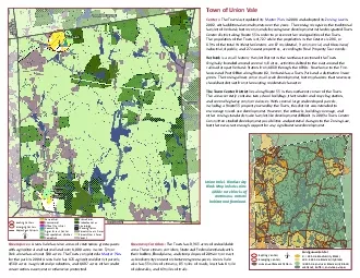
Contiguous Habitat1000 cre nd vr iodiversity locks200 99 cre iodiversity locks0 99 Acre iodiversity locksWetlands uffers nd teep lopesHuman ettlement atternEmerging entersExisting entersoCD82C55457894 ID: 868159
Download Pdf The PPT/PDF document "Town of Union Vale Centers The Town last..." is the property of its rightful owner. Permission is granted to download and print the materials on this web site for personal, non-commercial use only, and to display it on your personal computer provided you do not modify the materials and that you retain all copyright notices contained in the materials. By downloading content from our website, you accept the terms of this agreement.


1 Town of Union Vale Centers: The Town las
Town of Union Vale Centers: The Town last updated its Master Plan in 2001 and adopted its Zoning Law2002, with addi�onal amendments over the years. The zoning recognizes the tradi�onal hamlet of Verbank, but recommends focusing new development in the designated Town Center district along Route 55 in order to preserve the rural quali�es of the Town.The popula�on of the Town is 4,727 while the popula�on in the Centers is 296, or6.3% of the total. Within the Centers are 87 residen�al, 3 commercial, and 1 business/industrial, 4 public, and 27 vacant proper�es, according to Real Property Tax records.Verbank is a small historic Hamlet District in the northeast sec�on of the Town.Originally founded around several mill sites, ac�vi�es shi�ed to the east around therailroad stop at Verbank Sta�on from 1869 through the 1930s. Now home to the Fire- house and Post O�ce along Route 82, Verbank has a Town Park and a dis�nc�ve linear green. The zoning allows some small-scale development, but emphasizes that new uses should not detract from the exis�ng residen�al character.The Town Center District lies along Route 55 in the southwest corner of the Town.The area currently contains two school buildings, the transfer and recycling sta�on,and several highway commercial uses. With several large undeveloped parcels,including a Route 55 property owned by the Town, this district was intended toencourage mixed-use development. However, the setbacks, building coverage, andother zoning standards make hamlet-like development di�cult. In 2003 a Town Center Commi�ee studied development possibili�es and poten�al changes to the Zoning Law, but there was not enough support for any signi�cant new development.Greenspaces: Union Vale has nine areas of con�nuous greenspaces with agricultural and natural land over 1,000 acres in size. Tymor Park alone has almost 500 acres. The Town completed a Master Planfor the park in 2004. Union Vale has 176 agricultural district parcels,4,560 acres in agricultural produc�on, and 1,197 acres either under conserva�on easement or otherwise protected. Union Vale’s Biodiversity 1,000+ acre blocks of con�nuous naturalhabitat and farmland. Contiguous Habitat 1000 cre nd vr iodiversity locks 200 99 cre iodiversity locks 0 99 Acre iodiversity locks Wetlands, uffers, nd teep lopesHuman ettlement attern Emerging entersExisting enters o CD82C554578945794572445790457324572145723 UnionValeCnter BEEKMAN PLEASANT VALLEY DOVER WASHINGTON Verbank LAGRANGE Greenway Corridors: The Town has 9,365 acres of unbuildablearea. These stream corridors, State and Federal wetlands withtheir bu�ers, �oodplains, and steep slopes of 20% or more actas biodiversity connectors between greenspaces. Union Valealso has 55 miles of streams, 85 miles of roads, less than 1 mileof sidewalks, and 13 miles of trails. Mjor County T r a i l sEmerging entersExisting enters Hydrology Protected ands Parcels Ovr 5 AcresParcels Under 5 Acres Working arms VacantPublic arks Residential Commercial Transportation, tilities CommunityOffice ndustrial Agriculture in Center Recreation o