
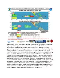
Tropical Storm Bertha develope d over the central Atlantic east of the Lesser Antilles on July 31 The latest NHC forecast guidance brings Bertha on a track through the northeastern Caribbean near Puerto Rico and Hispanola and then near the eastern B ID: 10028
Download Pdf The PPT/PDF document "The amplitude of the MJO RMM Index has d..." is the property of its rightful owner. Permission is granted to download and print the materials on this web site for personal, non-commercial use only, and to display it on your personal computer provided you do not modify the materials and that you retain all copyright notices contained in the materials. By downloading content from our website, you accept the terms of this agreement.


The amplitude of the MJO RMM Index has decreased considerably over the past several days as higher frequency modes of tropical convective anomalies dominate the pattern. Tropical Storm Bertha develope d over the central Atlantic east of the Lesser Antilles on July 31. The latest NHC forecast guidance brings Bertha on a track through the northeastern Caribbean, near Puerto Rico and Hispanola, and then near the eastern Bahamas before recurving over the no rthern Atlantic. Over the eastern Pacific, Tropical Storm Iselle developed and is forecast to strengthen to hurricane intensity while moving on a westward track. Additional tropical cyclogenesis is possible over the eastern Pacific both west (moderate conf idence) and east (high confidence) of Iselle during the remainder of the Week - 1 period. Additional tropical disturbances were also observed south of Hawaii, including the remnants of Tropical Storm Genevieve, but there is lower confidence for development in this area. There is a potential for tropical cyclone related impacts, including heavy rainfall, high seas, and winds, over the Hawaiian Islands during Week - 2. Over the western Pacific, tropical cyclogenesis is still possible over the east China Sea or n ear Japan in association with a broad monsoon low. Several ensemble GFS members continue to develop a tropical cyclone west of the Date Line during Week - 2, so the moderate confidence shape was maintained and shifted south to reflect the latest guidance. P recipitation shapes were adjusted in the outlook to reflect the latest model guidance, including tropical cyclone impacts. The original forecast discussion released July 29 follows. ------------------------------ The MJO remained generally incoherent during the previous week, as other modes of anomalous tropical convection continued to dominate the pattern. The amplitude of the RMM Index increased during the past several days, as a large scale dipole of enhanced c onvection over the Pacific and suppressed convection over the equatorial Indian Ocean and Maritime Continent projected strongly onto Phase - 7 of the Wheeler - Hendon diagram. The CPC velocity potential index remains fairly weak, however, despite a correspond ing robust Wave - 1 type VP anomaly pattern observed over the global tropics during the past few days. A strong Kelvin Wave currently propagating over the Atlantic is interfering with the signal, which may be contributing to the weakness in the CPC index. Little eastward propagation of the enhanced convection over the Pacific is evident, as the signal is comprised primarily of higher frequency modes such as Kelvin Waves and tropical cyclones. Many dynamical models including the GFS, ECMWF, Canadian, and Ja panese, favor a rapid eastward propagation of the MJO signal, with increasing amplitude over the Indian Ocean or Maritime Continent by Week - 2. This phase speed is inconsistent with MJO activity, and more suggestive of a model response to the Kelvin Wave c urrently propagating over the Atlantic. Anomalous upper - level westerly wind anomalies are currently observed over Africa and the Indian Ocean, which would tend to inhibit outflow necessary for the development of robust MJO - related tropical convection. St atistical models such as the Constructed Analog favor eastward propagation of the current signal over the Pacific. Based on recent observations, the future evolution of any MJO signal is highly uncertain. Two tropical cyclones developed over the eastern Pacific during the past week. Tropical Storm Genevieve developed on July 25, followed by Hurricane Hernan on July 26. Both systems weakened over open water, although the remnants of Genevieve are moving through an area that is somewhat conducive for pote ntial redevelopment. Typhoon Halong developed east of Guam on July 28, and is currently forecast to intensify while passing near or just north of Guam. Model forecasts indicate a recurving track for Halong, with potential impacts for Japan later in the W eek - 1 period. A tropical wave over the central Atlantic has become increasingly organized during the past two days, and there is a high probability for tropical cyclone formation during the Week - 1 period. Most model forecasts indicate a recurving track o ver the central Atlantic. Over the eastern and central Pacific, several areas embedded in an active ITCZ are favored for potential tropical cyclogenesis, including one or more systems south or southeast of Hawaii. This activity may contribute to enhanced seas or rainfall near the Hawaiian islands. Further west, there is a high confidence potential for tropical cyclone development associated with a monsoon low east of the Philippines. Model forecasts bring this potential system into the East China Sea du ring the Week - 1 period. During Week - 1, enhanced convection, partly associated with tropical cyclone activity, is favored over the northwestern Pacific from the northern Philippines eastward to 150E. Enhanced convection is also favored near and south of H awaii, extending eastward along the ITCZ. Enhanced North American Monsoon activity is also favored, with areas of heavy rainfall possible over northwestern Mexico and southwestern New Mexico. Dynamical models favor suppressed convection across southern I ndia, the eastern Indian Ocean, the Maritime Continent, and the equatorial West Pacific. There is decreased confidence for the Week - 2 outlook due to uncertainty regarding the evolution of the global tropical pattern. The GFS and CFS favor a continuation of enhanced convection near and east of the northern Philippines during Week - 2, with suppressed convection forecast north of New Guinea. Enhanced convection is also possible across the eastern Pacific east of Hawaii, especially if there are any ongoing tr opical cyclones. Several GFS ensemble members indicate a potential for tropical cyclone development over the western Pacific east of 150E during Week - 2. Forecasts of enhanced or suppressed convection across some parts of Africa are based on regional scal e anomaly features and were produced based on collaboration with the CPC Africa Desk.