
1422020Codebook Urbanicity DataWe provide two tracklevel urbanicity measures one based on the latest USDA ruralurban commuting area RUCAcodes 20101and one based on the high level National Center f ID: 858568
Download Pdf The PPT/PDF document "UrbanicityCodeBookdocx" is the property of its rightful owner. Permission is granted to download and print the materials on this web site for personal, non-commercial use only, and to display it on your personal computer provided you do not modify the materials and that you retain all copyright notices contained in the materials. By downloading content from our website, you accept the terms of this agreement.

1 Urbanicity_CodeBook.docx 1 4/2/2020
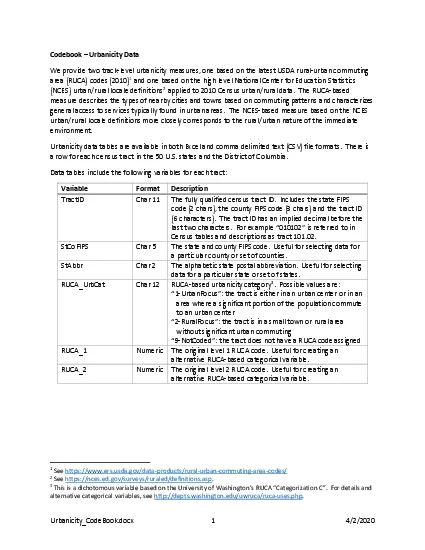
Urbanicity_CodeBook.docx 1 4/2/2020 Codeb ook – Urbanicity Data We provide two track - level urbanicity measures, one based on the latest USDA rural - urban commuting area (RUCA) codes (2010) 1 and one based on the high level National Center for Education Statistics (NCES) urban/rural locale definitions 2 applied to 2010 Census urban/rural data. The RUCA - based measure describe s the types of nearby cities and towns based on commuting patterns and characterize s general access to services typically found in urban areas. The NCES - based measure based on the NCES urban/rural locale definitions more closely corresponds to the rural/urban nature of the immediate environment. Urbanicity data tables are available in both Excel and comma delimited text (CSV) file formats. There is a row for each census tract in the 50 U.S. states and the District of Columbia. Data tables include the following variables for each tract: Variable Format Description Tract ID Char 11 The fully qualified census tract ID. Includes the state FIPS code (2 chars), the county FIPS code (3 chars) and the tract ID (6 c haracters). The tract ID has an implied decimal before the last two characters. For example “010102” is referred to in Census tables and descriptions as tract 101.02. StCoFIPS Char 5 The state and county FIPS code. Useful for selecting data for a particular county or set of counties . StAbbr Char 2 The alphabetic state postal abbreviation. Useful for selecting data for a particular state or set of states . RUCA_UrbCat Char 12 RUCA - based urbanicity category 3 . Possible values are: “1 - UrbanFocus”: the tract is either in an urban center or in an area where a significant portion of the population commute to an urban center “2 - RuralFocus”: the tract is in a small town or rural area without significant urban commuting “9 - NotCoded”: the tract does not have a RUCA code assigned RUCA_1 Numeric The original level 1 RUCA code. Useful for creating an alternative RUC A - based categorical variable . RUCA_2 Numeric The original level 2 RUCA code. Useful for creating an alternative RUC A - based categorical variable . 1 See https://www.ers.usda.gov/data - products/rural - urban - commuting - area - codes/ 2 See https://nces.ed.gov/surveys/ruraled/definitions.asp . 3 This is a dichotomous variable based on the University of Washington’s RUCA “Categorization C” . For details and alternative categorical variables, s ee http://depts.washington.edu/uwruca/ruca - uses.php . Urbanicity_CodeBook.docx 2 4/2/2020 Variable Format Description NCES_UrbCat Char 8 Urbanicity category using NCES urban/rural locale definitions applied to Census urban/rural popu lation data. Possible values are: “1 - City” : 90% or more of the tract population is living in a large urban area and a principal city “2 - Suburb”: 90% or more of the tract population is living in a large urban area and not in a principal city “3 - Town”: 90% or more of the tract population is living in a small urban cluster “4 - Rural”: 90% or more of the tract population is not living in an urban area or urban cluster “5 - Mixed”: None of the above – the tract population is living in a mix of urbanicity types “9 - NoPop”: the tract had a population of zero in the 2010 Census NCES_PctCity Numeric Percent of the tract population is li
2 ving in a large urban area and a princi
ving in a large urban area and a principal city . Useful for creating an alternative NCES - based categorical variable. NCES_PctSuburb Numeric Percent of the tract population is living in a large urban area and not in a principal city. Useful for creating an alternative NCES - based categorical variable. NCES_PctTown Numeric Percent of the tract population is living in a small urban clust er. Useful for creating an alternative NCES - based categorical variable. NCES_PctRural Numeric Percent of the tract population is not living in an urban area or urban cluster. Useful for creating an alternative NCES - based categorical variable. Vintage 2017 tract IDs are used. These including all tract and county coding changes made through 2017. For details, see https://www.census.gov/p rograms - surveys/acs/technical - documentation/table - and - geography - changes.html . Urbanicity_CodeBook.docx 1 4/2/2020 Codebook Urbanicity Data We provide two track - level urbanicity measures, one based on the latest USDA rural - urban commuting area (RUCA) codes (2010) 1 and one based on the high level National Center for Education Statistics (NCES) urban/rural locale definitions 2 applied to 2010 Census urban/rural data. The RUCA - based measure describe s the types of nearby cities and towns based on commuting patterns and characterize s general access to services typically found in urban areas. The NCES - based measure based on the NCES urban/rural locale definitions more closely corresponds to the rural/urban nature of the immediate environment. Urbanicity data tables are available in both Excel and comma delimited text (CSV) file formats. There is a row for each census tract in the 50 U.S. states and the District of Columbia. Data tables include the following variables for each tract: Variable Format Description Tract ID Char 11 The fully qualified census tract ID. Includes the state FIPS code (2 chars), the county FIPS code (3 chars) and the tract ID (6 c haracters). The tract ID has an implied decimal before the last two characters. For example “010102” is referred to in Census tables and descriptions as tract 101.02. StCoFIPS Char 5 The state and county FIPS code. Useful for selecting data for a particular county or set of counties . StAbbr Char 2 The alphabetic state postal abbreviation. Useful for selecting data for a particular state or set of states . RUCA_UrbCat Char 12 RUCA - based urbanicity category 3 . Possible values are: - UrbanFocus”: the tract is either in an urban center or in an area where a significant portion of the population commute to an urban center - RuralFocus”: the tract is in a small town or rural area without significant urban commuting - NotCoded”: the tract does not have a RUCA code assigned RUCA_1 Numeric The original level 1 RUCA code. Useful for creating an alternative RUC A - based categorical variable . RUCA_2 Numeric The original level 2 RUCA code. Useful for creating an alternative RUC A - based categorical variable . 1 See https://www.ers.usda.gov/data - products/rural - urban - commuting - area - codes/ 2 See https://nces.ed.gov/surveys/ruraled/definitions.asp . 3 This is a dichotomous variable based on the University of Washington’s RUCA “Categorization C” . For details and alternative categorical variables, s ee http://depts.washington.edu/uwruca/ruca - uses.php