
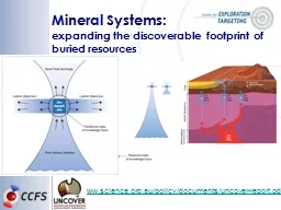
Geological models Mineral Systems after Kelley et al 2006 Supergene regolith processes Hypogene source pathway depositional site outflow Contrasting physicochemical conditions ID: 1021506
Download Presentation The PPT/PDF document "Alteration Spectral Mineral Models" is the property of its rightful owner. Permission is granted to download and print the materials on this web site for personal, non-commercial use only, and to display it on your personal computer provided you do not modify the materials and that you retain all copyright notices contained in the materials. By downloading content from our website, you accept the terms of this agreement.


1. Alteration Spectral Mineral Models
2. Geological models – “Mineral Systems”after Kelley et al., 2006 Supergene : regolith processes Hypogene : source, pathway, depositional site, outflow Contrasting physicochemical conditions Large mineral alteration footprints Mineral-chemical gradients litho-geochemical modelling Asking the right questions2 |Alteration Spectral Mineral Models
3. TechnologiesGeoscience-tuned VIRS systemsProximal (hyperspectral)VNIR &/or SWIR: PIMA, FieldSpec/TerraSpec (ASD)handheld FTIRsDrill core: HyLogging (CSIRO, FLSmidth), HCI-3 (Corescan), HCIS (Terracore)3 |Alteration Spectral Mineral ModelsAirborne (hyperspectral)HyMap , HyVista corporation SEBASS , Aerospace CorporationCASI-SASI-MASI-TASI-TADI , ITRESaisaFENIX, aisaOWL, SpecimHySpex, Norsk Elektro OptikkSatellitesASTER , multispectral (launched 1999): 3 VNIR, 6 SWIR, 5 TIRHyperion, hyperspectral (launched 2001): VNIR/SWIRWorldView3, multispectral (launched 2013): 8 VNIR + 8 SWIRPlanned hyperspectral missions: HySpiri (launch > 2015); HISUI (launch > 2015); EnMap (launch > 2017)
4. Spectral resolutionB6B7B8B9a) High-resolution infrared reflectance spectra acquired with Bruker Vertex 70, down sampled to b) HyMap (airborne hyperspectral) and c) ASTER (satellite multispectral) resolution (band widths in grey; B5/B4 in colours). B4B5epidotebasalt + amphibole veinactinolite in calcsilicatetremoliteactinolitecummingtonitetalcbasalt + amphibole veinriebeckiteFe-chlorite2080D2390W2390Dc)b)a)Bruker Vertex 70HyMapASTERmultispectral: mineral groupshyperspectral: mineral species4 |Alteration Spectral Mineral Models
5. Mineral deposits in the Eastern Goldfields, Yilgarn Craton, Western AustraliaGeoscience Australia’spmd*CRC GOCAD modelEastern GoldfieldsEastern GoldfieldsproximaldistalArchaean Au alteration – Mafic/UM Rocks Komatiite associated Fe-Ni sulphide mineralisation Archean Au: structurally controlled syn-gold alteration (Neumayr et al., 2004) reduced pyrrhotite-biotite-amphibole, and oxidised plagioclase-carbonate-pyrite-magnetite-hematite-biotite-chlorite alteration > Au deposited at physicochemical gradientsMg#(modified after Huntington et al., 1999)Magnetite destruction (carbonation)5 |Alteration Spectral Mineral Models
6. Archean Au, Eastern Goldfields, WA – Terrane ScaleRemote SensingGeoscience Australia’spmd*CRC GOCAD modelEastern GoldfieldsBoulder-Lefroy faultSpeedway faultOckerburyfaultKunanalingfaultKanownafaultgranitesKambalda20 km6 |Alteration Spectral Mineral Models
7. Fe2+ ass. with in MgOHhighlowArchean Au, Eastern Goldfields, WA – Terrane ScaleRemote Sensing – Mapping mafic/um rocksSpeedway faultOckerburyfaultKunanalingfaultKanownafaultgranitesBoulder-Lefroy faultNote: open pits:North: phengitic white micasSouth: biotite7 |Alteration Spectral Mineral Models
8. Archean Au, Eastern Goldfields, WA – Camp ScaleRemote Sensing – Mapping mafic/um rocksFe2+ ass. with MgOHhighlowblack below threshold8 |Alteration Spectral Mineral Models
9. Archean Au, Eastern Goldfields, WA – Camp ScaleRemote Sensing, Tramways areaProt. DikeTramways area, imbricate thrust complexTMIMagnetite destruction, due to carbonation?9 |Alteration Spectral Mineral Models
10. Regional/camp scalelithology vs. alteration Fe2+ ass. with MgOHhighlowhighlowTalc-amphibole abundanceTMItalcFe-chlFe-amphiboletalcmodified after Murdie et al. (2010)Black Flag BedsParinga BasaltLunnon BasaltKambalda KomatiiteDevon Consols BasaltDefiance DoleriteProterozoic DykeMagnetite destruction, due to carbonation?10 |Alteration Spectral Mineral Models
11. Camp Scale: Drill Core Archean Au, Eastern Goldfields, WAAmphiboleTalc-AmphiboleCalcite-DolomiteMagnesiteDolomiteCalcite-DolomiteMagnesiteFe-ChlInt-ChlInt-ChlMg-rich to Intermed. ChloriteMg# --- varying amphibole compositions? ---- --- magnesite --- dolomite --- calcite ---Amphibole – Talc abundanceChlorite abundanceCarbonate abundanceFe2+ abundCarb compChl compdepth [m]Au [ppm]main ore zoneFault?proximaldistaldistalMagnetite destruction (carbonation)magnesitedolomitecalcitetalcFe-amphiboleMg-richFe-rich11 |Alteration Spectral Mineral Models
12. Iron-oxide copper-gold deposits (IOCG)IOCG modelP435 Project (1997)12 |Alteration Spectral Mineral Models
13. Alteration Spectral Mineral ModelsPorphyry-epithermal-skarnAlteration ZonationAlteration Zonation (mineralogy)ASTER Geoscience productsExoskarngarnet/pyroxeneMafic indexcalcite/dolomiteCarbonate index, Mafic indexEndoskarn - PorphyryPropyllitic (epidote/chlorite/amphibole)FeOH Group content, Ferrous iron in MgOH; MgOH group content; MgOH group compositionPhyllic (white mica)AlOH Group content, AlOH group compositionPotassic (ferrous silicates: biotite/chlorite/amphibole)Ferrous iron in MgOHEpithermalsilicicQuartz index; Silica index; Advanced Argillic: (alunite/pyrophyllite/kaolinite/dickite/mica)Kaolin indexferric oxides (hematite, goethite, jarosite) Ferric oxide content; ferric oxide composition; FeOH group content; ferrous index 13 |
14. Integrated analysis for mapping and mineralisation+ geochemistry14 |Alteration Spectral Mineral Models
15. Alteration Spectral Mineral ModelsExercise 1Exercise 1: Based on the given reflectance spectra interpret the mineralogy of samples using the USGS library (Appendix 2)Five of the samples stacked in order of their location along a transect. > What can be said about the alteration facies shown by these minerals, including alteration zonation (annotate of the figure) and likely style of mineralisation (see Appendix 1)?Annotate Figures!15 |
16. Thank youCSIRO Mineral ResourcesCarsten LaukampSenior Research Geoscientistt +61 8 6436 8754e carsten.laukamp@csiro.auw http://c3dmm.csiro.au/