
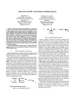
Assessing the climate impacts of land cover and land management using an eddy flux tower cluster in New England Land use land management and land cover change influence both local and global climate through changes in net greenhouse gas exchange albedo evapotranspiration and aerodynamic ID: 533450
Download Presentation The PPT/PDF document "Challenges… Hysteresis in Carbon Uptak..." is the property of its rightful owner. Permission is granted to download and print the materials on this web site for personal, non-commercial use only, and to display it on your personal computer provided you do not modify the materials and that you retain all copyright notices contained in the materials. By downloading content from our website, you accept the terms of this agreement.


Slide1
Challenges… Hysteresis in Carbon Uptake
Assessing the climate impacts of land cover and land management using an eddy flux tower cluster in New England
Land use, land management, and land cover change influence both local and global climate through changes in net greenhouse gas exchange, albedo, evapotranspiration, and aerodynamic roughness. We used a cluster of eddy flux towers located within 7.5 km of one another in southern New Hampshire across four land cover types—mixed forest, cornfield, hayfield, and impervious surface—to investigate the impact of land use on land-climate interactions in New England. Preliminary results from 2013-2016 indicate that the forested site had the lowest annual and growing season albedo of all 4 land cover types, but maintained the lowest surface temperature. The low surface temperature appears to be maintained due to both evapotranspiration as well as its comparatively high aerodynamic roughness and
exchange of sensible heat compared to the other 3 land cover types. Contrary to expectations,
the agricultural sites had latent heat fluxes similar to or greater than the forested site.
Abstract
Albedo
Data derived from the eddy flux systems have direct relevance to the
EPSCoR
Ecosystems & Society project, as they will be used not only by terrestrial and hydrologic modeling groups, but also to assess climate and future land-use scenarios. By understanding how each component of the landscape contributes to the surface energy budget, we will be better able to estimate climate forcing under various land-use scenarios. This knowledge will help inform decisions about future land use.
Andrew Ouimette
(Andrew.Ouimette@unh.edu
), Lucie
Lepine
, Scott Ollinger, Elizabeth Burakowski
Earth Systems Research Center, University of New Hampshire, Durham, NH 03824, USA
Moore Cornfield, Durham, NH
Thompson Forest, Durham, NH
Kingman Hayfield,
Madbury
, NH
West Edge Parking Lot, Durham, NH
Eddy Flux Tower Sites
Carbon Fluxes
Latent and Sensible Heat
Surface Roughness
r
Conclusions and Future Directions
Differences in Energy and Heat Loss
Figure 8:
Plot of CO
2
flux versus incoming shortwave radiation at Kingman Farm Hayfield (April through October) during the morning
(a) and evening hours (b). Note the lack of CO2 uptake in the morning measurements even up to 250 W/m2 incoming shortwave radiation. During the evening hours, however, net CO2 uptake occurs even at low light levels.
Future work will focus on: Gap fillingUsing airborne and satellite remote sensing data layers to upscale field estimates of net carbon fluxes from eddy covariance sitesModeling, with a focus on understanding the effect of vegetation on climate under possible future land use/land cover scenarios and different types of land management
Figure 2: Photographs of the 4 sites that are part of the eddy covariance tower cluster in southern New Hampshire. The sites span 4 land cover types and include a mixed forest, a managed hayfield, a managed cornfield, and a parking lot (impervious surface). At the 3 vegetated sites, land cover is homogeneous for at least 300 meters in the dominant wind direction from the tower.
Outgoing Longwave Radiation
Latent Heat Flux
Sensible Heat Flux
Albedo
Eddy Flux Tower Cluster
Figure 5:
Smoothed fit of daily carbon dioxide (CO
2
) flux for the 4 land cover types. Note the relatively short but intense growing season at the cornfield (green), as well as the longer growing season punctuated by harvests at the hayfield (red).
Figure 1:
Land cover map
(a)
and land surface temperature map
(b)
of the region surrounding the cluster of eddy flux towers in southern New Hampshire. Land surface temperature was derived from Landsat 8 thermal imagery from July 11, 2015. Circles show the location of the 4 flux tower sites. The three developed areas on the maps from north to south are the towns of Dover, Durham, and
Newmarket
, New Hampshire, with populations of approximately 30, 14, and 9 thousand residents, respectively.
The forested site acted as a moderate C sink during the 3-year period we examined. While eddy covariance measurements indicate that the agricultural sites were also moderate C sinks during this period, when we accounted for C added and removed during management, the agricultural sites were near carbon neutral.
This cluster of flux towers offers the possibility to more directly assess the impact of land use on land-climate interactions. Results thus far suggest tradeoffs between biophysical (albedo) and greenhouse gas
forcings
that have relevance to global climate, and also highlight the importance of aerodynamic roughness for influencing local surface climate.
Figure 3:
Smoothed fit of daily shortwave albedo versus day of year (DOY) across the 4 land cover types. The forest site maintains the lowest albedo of all sites.
Figure 4:
Smoothed fit of
(a)
daily latent heat flux (LE) and
(b) daily sensible heat flux (H) for the 4 land cover types.
Figure 6: Friction velocity (u*) versus wind speed for half-hourly measurements across the 4 land cover types. Arrows indicate when a canopy was present or not at the agricultural field sites. Note the higher friction velocity at a given wind speed at the forested site compared to the sites with shorter stature or no vegetation.
Day of Year
CO
2 Flux (umoles/m2/sec)
Morning
Evening
Figure 7:
Comparison of outgoing (land surface to the atmosphere) energy fluxes by land cover type.. “Outgoing longwave radiation” is calculated as the difference between measured outgoing longwave radiation and that of the forested site. Here, “albedo” represents outgoing shortwave radiation. Note the relatively low albedo of the forest and its large sensible heat flux (similar to the parking lot). The agricultural sites had similar latent heat fluxes to those from the forested site, with much lower sensible heat fluxes.
(a)
(b)
(a)
(b)
(a)
(b)
Earth Systems Research Center
Institute for the Study of Earth, Oceans, and Space
Results
thus far suggest the climate impacts of land cover and land management largely involve tradeoffs between albedo and greenhouse gas forcings at global scales, while latent heat and aerodynamic roughness (related to sensible heat flux) have a large influence on local surface climate.
This study is supported by National Aeronautics and Space Administration (NASA) through the Carbon Cycle Science Program (award number NNX14AJ18) and the NH
EPSCoR
Program. Support for the NH
EPSCoR
Program is provided by the National Science Foundation's Research Infrastructure Improvement Award # EPS 1101245.
Acknowledgements
Site comparison summary for first 3 years of measurements:
the forest site had the lowest annual and growing season albedo, and maintained the lowest surface temperature
the agricultural sites had latent heat fluxes similar to or greater than the forest
site but comparatively lower sensible heat fluxes
the forest site was a moderate C sink; eddy covariance measurements indicate that the agricultural sites were also moderate C sinks, but when C added and removed during management was accounted for, the agricultural sites were near carbon neutral
Ameriflux Spet 21-24, 2016