
Outer Banks Landform Change of Hurricane I sabel on Hatteras Island North Carolina Barrier islands stretching from Virginia to North Carolina and includes most of North Carolinas coastline ID: 623541
Download Presentation The PPT/PDF document "Hurricane Effects on the" is the property of its rightful owner. Permission is granted to download and print the materials on this web site for personal, non-commercial use only, and to display it on your personal computer provided you do not modify the materials and that you retain all copyright notices contained in the materials. By downloading content from our website, you accept the terms of this agreement.


Slide1
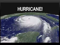
Hurricane Effects on the Outer Banks
Landform Change of Hurricane
I
sabel on Hatteras Island
North CarolinaSlide2
Barrier islands stretching from Virginia to North Carolina and includes most of North Carolina’s coastline.The Outer Banks (OBX)Slide3
Barrier island in Outer BanksDivides Atlantic Ocean & Pamlico Sound85.56 squares miles4,001 residents in 2000 censusKnown for sport fishing, surfing, windsurfing, kiteboardingMany resorts and vacation rentalsHatteras IslandSlide4
TemperateMild but windy wintersCooler than inland summersProne to hurricanes ClimateSlide5
Largest in 2003 season51 total indirect deathsWidespread wind and storm surge damageNC landfall as Category 2 Hurricane$170 million NC damagesHurricane IsabelSlide6
Hatteras Island washout (USGS)Slide7
Illustrate land cover changes on Hatteras Island before and after IsabelMultiple class changesLand to sea changesExplore why certain areas are more prone to damage Why was Hatteras Inlet made where it was?Project ObjectivesSlide8
Downloaded Landsat 5 imageryUnzip filesLoad and stack bands in ErdasMethodologySlide9
Unsupervised 11 classesSlide10
Image clipSlide11
Import into
IdrisiSlide12
ReclassSlide13
Cross ClassificationSlide14
BooleanSlide15
Boolean Cross ClassificationSlide16
DEMSlide17
Cross Classification TableSlide18
AreaSlide19
Boolean Cross Classification TableSlide20
Boolean AreaSlide21
Discussion
317 hectares of land lost to erosion/floodingSlide22
Hatteras Inlet and FloodingSlide23
Why did washout happen?Why did it happen here?Why not further up or down shore?What made this section so vulnerable?Why did flooding occur where it did?Questions AskedSlide24Slide25Slide26
Elevation and vegetation cover are very crucial factorsImportant to predict and prepare areas of high riskHow will climate change and sea level rise influence?Understand today -> Understand the futureConclusionSlide27
Questions?