
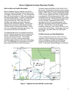
1 Exxon x2013 Highland Site Location and Facility Description Exxonx2019s HighlMnd urMnium mill site is located in Converse County Wyoming about 3 5 mi les north of Douglas Wyoming Fi ID: 507237
Download Pdf The PPT/PDF document "Uranium Recovery Facility" is the property of its rightful owner. Permission is granted to download and print the materials on this web site for personal, non-commercial use only, and to display it on your personal computer provided you do not modify the materials and that you retain all copyright notices contained in the materials. By downloading content from our website, you accept the terms of this agreement.


1 Exxon – Highland Uranium Recovery Facility Site Location and Facility Description Exxon’s HighlMnd urMnium mill site is located in Converse County, Wyoming , about 3 5 mi les north of Douglas , Wyoming (Figure 1) . The mill operated from 1972 until shutdown i n 1984 and currently is in decommissioning status . A plume of contamination has been detected flowing to the east of the site onto private property. New wells have been installed , and samples are being collected to determine the extent of the plume. The Pit Lake (Figure 2) has also been contaminated and has elevated levels of uranium and selenium. These areas of contaminat ion will delay site closure. No new closure date has been estimated. The Highland mill used a conventional acid leach - solvent extra ction process to extract uranium from the ore. Approximately 2,190 acres of land was disturbed by mining activities. The minable uranium occurred as a roll - front deposit that trended roughly northwest in the area of the milling site. The mill tailings w ere deposited in an above - grade impoundment formed by damming an unnamed ephemeral tributary to the North Fork of Box Creek. Overburden removal for surface mining began in September 1970, and underground mining began in 1973, with the sinking of the Buffa lo Shaft. I n - situ recovery mining occurred in a pilot mine that was initiated i n 1972 and terminated in 1981. The overburden from new mining operations was placed in old mined out pits. The final two pits (Pits 3 and 4) were not filled. Beginning in Ma rch 1984, groundwater from the surrounding aquifer was allowed to discharge into the two pits, forming the Pit Lake. The Pit Lake is oriented roughly south e a st - north w est, covers about 110 acres, and is more than 130 f ee t deep. R eclamation work and ground water corrective action have taken place since 1984. Facility Licensing and Operating History A Source Materials License No. SUA - 113 9 was originally issued to Standard Oil Company of New Jersey, operating as Humble Oil and Refining Company , by the Atomic Energy Commission (AEC). Exxon (then Standard) began conventional Figure 1. Highland Uranium Mill Site Location Map 2 Figure 2. Highland Site Layout uranium milling at the Highland site in October 1972. Exxon owned and operated the uranium mi nes that provided the ore for the mill. A limited amount of toll milling also took place at the Highland facility. The mill processed about 10.5 million tons of uranium ore, which did not have significant concentration of vanadium or molybdenum typical of some uranium ores. The mill contained a conventional dry crusher and wet rod mill to separate the individual grains in the ore. The resulting slurry was leached with sulfuric acid and sodium chlorate at a pH of between 1 and 1.5. The uranium was sepa rated from the tailings through countercurrent decantation using a series of thickeners. Barren tailings were pumped into the basin at about 35 percent solids by weight. The uranium liquor was processed by solvent extraction to yield a rich eluate for ur anium precipitation and drying. All aspects of mining and milling ceased in 1984 when reclamation activities began. The uranium mill area, including the ore storage pads and the laboratory, has been cleaned up and the tailings buried under a radon barri er, eliminating nearly all potential for radiation exposures to workers or members of the general public from these sources. However, the reclamation operations may result in minimal exposure of workers to radioactive materials. All windblown material ha s been reclaimed to unrestricted release standards. The byproduct material exposure is limited to the groundwater pathway. T here is no current use of groundwater. Tailings Management and Disposal Tailings deposition took place from the mill startup in October 1972 until June of 1984. The resultant tailings consisted of sand and slimes fractions, which were discharged to an approximate 20 - acre tailings basin around the perimeter of the tailings basin , and causeways were built out into the tailings basi n. The rock formations mined at the site are primarily in the Paleocene Fort Union Formation, which underlies the Eocene Wasatch Formation and are composed of a stacked sequence of sedimentary rocks that generally consist of interbedded sandstones and sha les. 1 Source: ARCADIS. “Groundwater Well Locations and WDEQ and NRC Boundaries Map.” Lakewood, Colorado: ARCADIS. 2008. 3 During operation, seepage from the tailings basin resulted in the development of a groundwater mound under and around the tailings basin. As the mound grew, it eventually reached an elevation that caused tailings fluid seepage to enter the alluvial deposits downstream of the dam. The center of the dam was keyed into the underlying Tailings Dam Shale (TDSH), which prevented any seepage moving under the dam. However, the wings of the dam were not keyed into the TDSH and allowed seepage to move through the wings and outside of the tailings impoundment. In 1975, a sump system was constructed to capture this seepage and pump it back to the tailings basin. The underground and open pit mining that took place at the Highland site necessitated lowering the local water table below the working level in the mines. Groundwater at the site generally flows in an easterly direction. Stu dies done in 2007 by Exxon also suggest contamina n ts have seeped to the west into Pit Lake. Several amendments have been made to the license to allow alternate concentration limits (ACLs) f or groundwater at three of the p oint of c ompliance (POC) wells, o n a well - by - well, constituent - by - constituent basis. In 2009, Exxon submitted a notice of intent to redefine the proposed long - term surveillance and monitoring boundary, including the establishment of new and revised ACLs with associated POCs and points of exposure (POEs) . This proposal was not implemented because a plume of contamination was discove re d . The following groundwater protection standards were implemented in 200 6 for four POC well s ( Nos. 125, 175, 176 and 177 ) and on background well No. 182: a rsenic = 0.05 mg/L, cadmium = 0.01 mg/L, chromium = 0.1 mg/L, gross alpha = 15.0 pCi/L, lead = 0.05 mg/L, nickel = 0.1 mg/L, radium - 226 and 228 = 5.0 pCi/L, selenium = 0.05 mg/L, thorium - 230 = 0.55 pCi/L , and uranium = 0.03 mg/L . E xceptions were well 125 uranium = 0.089 mg/L , well 175 nickel = 1.8 mg/L , and radium - 226 and - 228 = 25 pCi/L , and well 177 uranium = 0.11 mg/L. Additional Information For more information about the Highland u ranium r ecovery f acility , visit the U.S. Nuclear Regulatory Commission ( NRC ) uranium recovery website at http://www.nrc.gov/info - finder/materials/uranium/ or contact the NRC facility project manager, Thomas McLaughlin , at (301) 415 - 5869 or tgm@nrc.gov .