
Patterson P L Healey S P St ID: 821259
Download Pdf The PPT/PDF document "Predicting biomass over large areas from..." is the property of its rightful owner. Permission is granted to download and print the materials on this web site for personal, non-commercial use only, and to display it on your personal computer provided you do not modify the materials and that you retain all copyright notices contained in the materials. By downloading content from our website, you accept the terms of this agreement.


Predicting biomass over large areas from
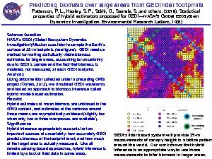
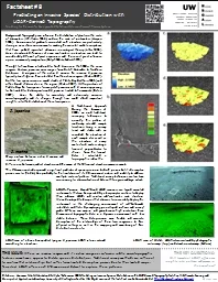
Predicting biomass over large areas from GEDI lidar footprintsPatterson, P. L., Healey, S. P., Ståhl, G., Saarela, S.,andothers. (2019). Statistical properties of hybrid estimators proposed for GEDIâNASAâs Global Ecosystem Dynamics Investigation. Environmental Research Letters, 14(6)Science QuestionNASAâs GEDI (Global Ecosystem Dynamics Investigation) Mission uses lidar to sample the Earthâs surface at 25-m footprints (see figure). GEDIneedsamethod for making statisticallyviablebiomass estimates for larger areas, accounting for uncertainty due to GEDIâs sample and the fact that biomass is modeled, not measured, at each GEDI footprint.AnalysisUsing airborne lidar collected under a preceding CMS project (Cohen, 2012), we simulated GEDI waveforms and tested an approach to biomass inference called hybrid model-based estimation.ResultsHybrid estimatesofmeanbiomassareunbiasedinthe GEDIcontext,andestimatesofthevariancearoundthosemeansareasymptoticallyunbiased(slightlylowwhenonlytwoorthreeoverpassesareavailable).SignificanceHybrid inference appropriately accounts for two important sources of uncertainty: how accurately GEDI predicts biomass at the footprint level;andhowmuchofthe target area is actually measured. Like all remote sensing-based approaches, hybrid inference is limited by alackoffielddatainsomeareas.GEDIâs lidar based system will provide 25-m measurements of canopy height ina lattice pattern around the world. Ourworkshows that hybrid inference is an appropriate way to use those measurements to infer biomass in larger areas.