
Contour lines are lines drawn on a map that connect points of equal elevation If you walk along a contour line you neither gain or lose elevation Picture walking along a beach exactly where the water ID: 573326
Download Presentation The PPT/PDF document "Contour Lines" is the property of its rightful owner. Permission is granted to download and print the materials on this web site for personal, non-commercial use only, and to display it on your personal computer provided you do not modify the materials and that you retain all copyright notices contained in the materials. By downloading content from our website, you accept the terms of this agreement.


Slide1
Contour LinesSlide2
Contour lines are lines drawn on a map that connect points of equal elevation. If you walk along a contour line you neither gain or lose elevation.
Picture walking along a beach exactly where the water
meets the land (ignoring tides and waves for this example).
The water surface marks an elevation we call sea level, or
zero.Slide3
As you walk along the shore your elevation will remain the same, you will be following a contour line.
If you stray from the shoreline and start walking into the ocean, the elevation of the ground (in this case the seafloor) is below sea level.
If you walk in the other direction and walk up the beach your elevation will be above sea level. Slide4
Sea Level
Above Sea Level
Below Sea LevelSlide5
Why are contour lines useful?
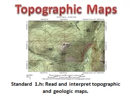
Contour lines are useful because they allow us to show the shape of the land surface (topography) on a map. Slide6Slide7
Sea LevelSlide8
Rising WaterSlide9
Contour LinesSlide10
What is this?Slide11
CONTOUR MAPSlide12
10 characteristics of contour lines
1. Contour lines are continuous.
2. Contour lines do not cross each other- but there are 2 exceptions
3. A series of V-shape indicates a valley and the V’s point to higher elevation.Slide13
4. A series U shape indicates a ridge. The U shapes will point to lower elevation.
5. Evenly spaced lines indicate an area of uniform slope.
6. A series of closed contours with increasing elevation indicates a hill and a series of closed contours with decreasing elevation indicates a depression.
characteristics of contour lines cont.Slide14
7. Closed contours may be identified with a +, hill, or -, depression
.
8. Closed contours may include hachure marks. Hachure marks are short lines perpendicular to the contour line. They point to lower elevation.
9. The distance between contour lines indicates the steepness of the slope. The greater the distance between two contours the less the slope. The opposite is also true.
characteristics of contour lines cont.Slide15
10.
A different type of line should be used for contours of major elevations. For example at 100, 50 and 10 foot intervals. Common practice is to identify the major elevations lines, or every fifth line, with a bolder, wider, line.
characteristics of contour lines cont.Slide16
Some
contour lines may
complete full circles (connect) but
others will not.
In
this case, they will start at a boundary line and end at a boundary line
.
Contours
must either close or extend from boundary to boundary.
1. Contours are ContinuousSlide17
Two
exceptions:
They will meet at a vertical cliff
They will overlap at a cave or overhang.
When
contour lines overlap, the lower elevation contour should be dashed for the duration of the overlap.
2. Contour lines do not crossSlide18
3. Valleys and higher elevation
A
valley is shown by a series
of V-shapes
where
the V’s point to the higher
elevation.Slide19
4. U shapes and ridge
A
series of U shapes indicates a ridge. The U shapes will point to lower elevation.Slide20
5. Contour Spacing
Evenly spaced contours indicate an area of
the same slope
.
Unevenly spaced contours indicates an area with variable slope.Slide21
A series of closed contours with increasing elevation indicates a hill.
Hills may be identified with a “+” with the elevations
6 & 7 Hills and Depressions Slide22
A
series of closed contours with decreasing elevation indicates a depression
.
Depressions may be
identified with a “-”.
6 & 7 Hills and Depressions--cont.Slide23
8.
Hachures
Hachures
are short lines which are perpendicular to the contour line
.
Used
to indicate a hill or a depression
.
Not
used on modern maps.Slide24
9. Contour Spacing
Contours
spaced wider apart indicate
lower slope
.
Contours spaced close together
indicate a higher slope.Slide25
9. Contour Spacing-Intervals
Another
decision that must be made is the contour interval
.
The
“best” interval depends on the use of the data.Slide26
10. Contour line
The thicker contour is
Called the index line.Slide27
How do you make a contour map?
Contour lines never cross
Contour lines never end- unless they go off the map
There must be equal intervals between contour lines
When contour lines are closer together, the slope is steeper
When the contour lines are spaces farther apart, the land is less steepSlide28Slide29
Contour MapSlide30
Play-
doh
worksheet