
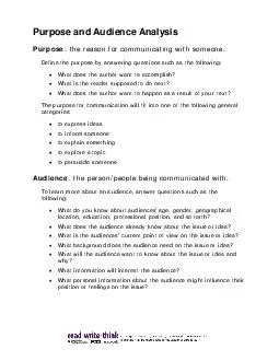
8718 What We Know about Purpose and Need Provides basis for developing and evaluating alternatives Should be clearly written succinct and well defined Should include a statement of project status to date ID: 998715
Download Presentation The PPT/PDF document "Purpose and Need Best Practices" is the property of its rightful owner. Permission is granted to download and print the materials on this web site for personal, non-commercial use only, and to display it on your personal computer provided you do not modify the materials and that you retain all copyright notices contained in the materials. By downloading content from our website, you accept the terms of this agreement.


1. Purpose and Need Best Practices8-7-18
2. What We Know about Purpose and NeedProvides basis for developing and evaluating alternativesShould be clearly written, succinct and well definedShould include a statement of project status to dateInitially developed through the transportation planning processMPO/TPO LRTPs, SIS Plans are the primary source of information Should be refined, as appropriate, during PD&E study
3. What We Know about Purpose and NeedPurpose and Need is used in Decision making process….evaluate project alternatives which meet the project’s purpose and need while balancing cost and level of environmental impact relative to the transportation benefits which will be obtained from the project implementation
4. What We Know about Purpose and NeedHow long is the purpose and need?………The Answer is…. It depends on project type and complexity (including number of issues “driving” the project)
5. Purpose and NeedPurpose Transportation problem to be solved “What” of the Proposed ActionObjectives of the projectNeed Data to support the problem (purpose)“Why” of the projectEvidence a problem existsBased on facts and numerical dataPurpose and Need are related If the purpose statement is based on safety improvements, the need statement should support the assertion that there is (existing) or will be (future) safety problem to be corrected
6. Purpose and Need is Not…A statement of solutionThe purpose of the project is to build a bypassThe purpose of the project is to widen corridor to a four-lane facilityThe purpose is to promote growth/economic developmentProject descriptionProject description defines the scope and location of the project
7. Project DescriptionContains the followingDescription of the existing facility Limits of the projectCity and County the project is located Proposed improvementsProject Description is not Purpose and NeedDoes the project have logical termini and independent utility?
8. 9 Elements of NeedThe transportation planning process should identify many of [these] elements if they contribute to the transportation problems
9. 9 Elements of NeedDescribe the action's history, including measures taken to date, other agencies involved, action spending, schedulesProject StatusProject Status should be described in all projectsProject Status is NOT Planning Consistency, ratherPlanning Consistency is a component of Project Status
10. Commonly Identified Project Needs
11. Other Elements of NeedIf one of these is mentioned, it must be supported by data and analysis
12. Primary vs. Secondary Needs
13. Primary vs. Secondary P&NThe purpose of this project is to improve roadway deficiencies (primary) along Mahan Drive between North Monroe Street and Capital Circle NE. Additionally, a goal of this project is to improve safety conditions (secondary) for vehicle and pedestrian traffic. Data must be provided to support both primary and secondary purposes.
14. Primary vs. Secondary P&NThe Purpose of this project is to address capacity deficiency and improve mobility along Interstate 99 between Exit 20 and Exit 25.Additionally, according to the 2009 list of congressionally earmarked projects, the funding should be used to widen Interstate 99 to six lanes from Skiway interchange to Donway interchange (- could be considered a secondary purpose.)Widening of Interstate 99 between Exit 20 and Exit 25 was earmarked by the Congress
15. P&N Application ExampleThrough the planning process, an MPO developed a Congestion Management Plan (CMP) which states that the MPO desires to achieve a LOS “E” for all urban roads. The identified need for the planning process of one main street corridor is a capacity deficiency (the projected LOS is “F” without improvements) and suggested solution is to widen the corridor. Alternatives (and future LOS) developed for this project include:Transportation System Management (TSM) – future LOS FTransportation Demand Management (TDM) – future LOS FAdd two lanes – future LOS EAdd four lanes – future LOS DIf the purpose and need is written “the purpose is to reduce congestion to meet MPO LOS standard”, then the TSM and TDM alternatives can be eliminated based on purpose and need.
16. Purpose and Need ExamplePurpose and Need for a project stated that:“Additional capacity on Capital Circle North East is needed between Mahan Drive and Centerville Road because this segment is congested during peak hours of operations.”What is the capacity of this segment?How does this segment handle current and projected travel (traffic) demand?What is the level of service (existing, and future)?Are the problems localized at the intersections?Missing in the discussion/statement…Review the analysis of the data (or supporting info) to verify the needs identified support the transportation problem
17. Purpose and Need Example 21.3 Need for the Project The project is needed to improve operational capacity, improve overall traffic operations to accommodate future growth and development, improve safety, and enhance emergency evacuation and response times. 1.3.1 Capacity 1.3.2 Transportation Demand1.3.3 Planning Consistency1.3.4 Social Demand and Economic Development1.3.5 System Linkage1.3.6 Traffic Safety1.3.7 Modal Interrelationships1.3.8 Roadway Deficiencies1.3.9 Related Projects within the Study Area
18. Purpose and Need Example 21.3.1 Capacity This project is needed to relieve current and projected future traffic congestion along the portion of I-95 from JTB to Atlantic Boulevard. A Systems Interchange Modification Report (SIMR) is being prepared as part of this study. The preliminary study results indicate that this portion of I-95 experiences peak period congestion with speeds below the posted speed limit due to demand that exceeds capacity. In 2014, I-95 operated at LOS F from Bowden Road to Atlantic Boulevard and at LOS D between JTB and Bowden Road. By 2040, the entire segment of I-95 within the study limits will operate at LOS F. This segment of I-95 is predicted to experience a 13% increase in traffic over the next 25 years. The resulting congestion will progressively increase with periods of congestion extending beyond the normal a.m. and p.m. peak periods. What is the baseline traffic?What is the current speed limit?
19. Purpose and Need Example 21.3.4 Social Demand and Economic Development I-95 serves major north-south traffic movements through the Jacksonville urban area. Within the limits of the study, I-95 connects suburban areas south of Jacksonville to downtown Jacksonville, as well as office, commercial, and industrial areas located along the I-95 corridor. Traffic demand on I-95 is directly related to population and employment changes. The population of Duval County is expected to increase by approximately 24% from 2010 to 2040, and employment is expected to increase by 21% during the same time period. The population and employment projections indicate that traffic volumes will continue to increase linearly with that growth. Adequate transportation infrastructure is an economic competitive requirement, providing critical access to employment hubs as well as local and regional mobility for the efficient delivery of goods and services. Top factors in attracting higher-wage employers to the area include: easy commuter access to job centers, minimizing traffic and congestion delays which results in decreased shipping costs, and intermodal linkages to airports, seaports and freight and passenger rail facilities. In addition, the project corridor is located in an Enterprise Zone (Jacksonville EZ-1601) and a US Department of Housing and Urban Development (HUD) Empowerment Zone. An Enterprise Zone is a specific geographic area targeted for economic revitalization. Enterprise and HUD Empowerment Zones encourage economic growth and investment in distressed areas by offering tax advantages and incentives to businesses located within the zone boundaries. … will the project address this? How?
20. Purpose and Need Example 21.3.7 Modal Interrelationships I-95 does not have any bicycle or pedestrian facilities with one exception – a pedestrian overpass is located just north of the University Boulevard interchange. The Jacksonville Transit Authority (JTA) operates two bus transit routes that briefly utilize I-95 north of Atlantic Boulevard: Routes 17 and 200. Other bus routes service the communities surrounding the interstate but do not utilize I-95. The Skyway Fixed Guided Transit Station - Kings Avenue Station is located on the north end of the project. Cool to Pool a free rideshare matching service provided by the North Florida TPO Commuter Services Program, is also available in this area. 1.3.8 Roadway Deficiencies I-95 is an aging interstate, and as such, a number of design elements do not meet current FDOT standards. The I-95 bridge over Bowden Road (#720331) and the I-95 bridge over San Diego Road (#720335) are both considered functionally obsolete. Other roadway deficiencies include: inside shoulder width, vertical curvature (stopping sight distance), and vertical clearance. The inside shoulder for the majority of the project corridor is deficient and varies from seven to eight feet. The vertical curves over JTB, Bowden Road, University Boulevard, Spring Glen Road, Emerson Street and San Diego Road do not meet current FDOT standards for vertical stopping sight distance. In addition, the vertical clearance is severely deficient at Bowden Road, University Boulevard, Spring Glen Road, Emerson Street and San Diego Road. What is the problem here? Will the project address these? How?VERY TRUE but are these related to the purpose?
21. Example 41.2 Purpose and Need for ActionThe primary purpose of the proposed action is to enhance overall traffic operations at the existing interchanges of SR‐9/I‐95 at SR 804/Boynton Beach Boulevard and at Gateway Boulevard by providing improvements to achieve acceptable Levels of Service (LOS) in the future condition (2040 Design Year). The proposed action will support redevelopment efforts in the vicinity of the interchange, meeting the overall vision of the City of Boynton Beach. In addition, goals of the project include improving safety conditions and enhancing emergency evacuation and response times. (The proposed action is anticipated to improve traffic operations at the study interchanges through implementation of operational and capacity improvements that will maintain and improve mobility, improve safety, and support existing and future development at the study interchanges).What constitute an acceptable (LOS)?This repeatsNeed specifics ..and Need should be supported by data
22. Example 32.2 System LinkageThe proposed new interchange will provide additional access to I-10 in conjunction with the planned Crestview Bypass officially known as the PJ Adams Parkway Extension. Approved in 2013 by a separate PD&E Study, the southern limits of the proposed bypass are generally from SR 85 to SR 10 (US 90), and include the existing PJ Adams Parkway and the subject section of Antioch Road having an overpass with I-10. Once completed, the full bypass will also connect US 90 and SR 85 north of Crestview, supporting both local and regional travel to bypass the heavily-traveled and congested segment of SR 85 through downtown Crestview.2.3 Social Demands or Economic DevelopmentThe University of Florida’s Bureau of Economic and Business Research (BEBR) projects Okaloosa County’s current population of 188,000 to grow to 223,500 by 2040 with medium population growth, which is an increase of 18%. As the population increases, roadway volumes are projected to increase as well, further exacerbating the need for improved mobility and accessibility in the study area. There are no planned developments in the vicinity of the proposed I-10 and Antioch Road interchange driving the need for the interchange.
23. Take Three! 3. Level of detail can vary and is a function of project type and complexity2. Does the Purpose and Need provide a clear basis for implementing the project? i.e. have the answer to “What is” and “Why this is” the project?1. Does the Purpose and Need clearly written, and will it help to consider and evaluate alternatives, and select preferred alternatives?