
Receive Site Fact Sheets by March 2016Have questionsSeeWho to ContactBelowInvestigation to Begin at State Superfund SiteNew York State Office of Parks Recreation and Historic Preservation OPRHP will s ID: 895159
Download Pdf The PPT/PDF document "Site Name Robert Moses Parkway South Si..." is the property of its rightful owner. Permission is granted to download and print the materials on this web site for personal, non-commercial use only, and to display it on your personal computer provided you do not modify the materials and that you retain all copyright notices contained in the materials. By downloading content from our website, you accept the terms of this agreement.


1 Site Name: Robert Moses Parkway - South
Site Name: Robert Moses Parkway - South SiteDEC Site #: 932166 Address: SW Corner of Inters Receive Site Fact Sheets by March 2016 Have questions? See "Who to Contact" Below Investigation to Begin at State Superfund Site N ew York State Office of Parks, Recreation, and Historic Preservation (OPRHP) will soon begin a detailed environmental study at the Robert Moses Parkway-South Site (site) located at SW Corner Remedial Action Plan. At least four IRM excavations are planned within the construction zone to address the discrete areas of contamination identified to date. All excavated material will be disposed of off-site at a properly permitted facilityIRM Work Plan that is approved of by DEC.Next StepsThe information collected during the investigation will be summarized in a report. After the site investigation has begun, OPRHP, with oversight provided by DEC, will conduct a Feasibility Study. This study uses information developed during the site investigation to develop and evaluate potential ways to clean up contamination related to the site. The information collected during the site investigation may also support the conclusion that no action, or no further action, is needed to address site-related contamination.DEC will then develop a draft cleanup plan, called a "Proposed Remedial Action Plan". This plan describes the remedy preferred by DEC, or, if warranted, a no action or no further action alternative. The draft cleanup plan explains the decision that led to the preferred remedy by discussing each alternative and the reasons
2 for choosing or rejecting it. The goal o
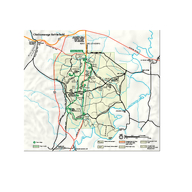
for choosing or rejecting it. The goal of the plan will be to ensure the protection of public health and the environment. DEfact sheet, and will present it to the public for its review and comment during a 30-day comment period and at a public meeting.Location: The site is located to the south-west of the intersection of John Daly Boulevard and Buffalo Avenue in the city of Niagara Falls at the eastern end of Niagara Falls State Park, which is operated by OPRHP. The site is bounded to the north by residential properties and a hotel, to the east by New York Power Authority property, and to the south by the Niagara River. The Niagara Falls State Park parcel continues to the west of the site towards Goat Island. Site Features: The site is approximately 17 acres in size. The site is bisected by the east-west lanes of Robert Moses Parkway. The site is within the Riverway construction project that is re-routing Robert Moses Parkway and expanding access to this portion of the park. The remainder of the site is mainly open parkland used for passive recreation. Current Zoning and Land Use: The site is currently part of Niagara Falls State Park operated by OPRHP.Past Use of the Site: New York State has owned the property since 1885 when the Niagara Reservation was created to preserve the land surrounding Niagara Falls. The north-eastern portion of the site historically contained the Port Day Pond, which was filled in starting in the 1930s. Southern portions of the site were created by the placement of large rock and other material into the Niagara R
3 iver during the construction of the Robe
iver during the construction of the Robert Moses Power Project in the 1960s. Contamination in the former pond area was initially discovered in 2013 prior to the reconfiguration the Robert Moses Parkway interchange. Additional areas of contamination were discovered in 2015 during utility installation and site grading work south of Robert Moses Parkway.Site Geology and Hydrogeology: Overburden soil consists of reworked fill composed of silt, sand, gravel and clay soils followed by silt and clay or silt and fine sand in the underlying native soils. Depth to bedrock varies slightly but is usually 8 to 12 feet below ground surface. In areas of man-made land the overburden soil typically consists of a thin layer of topsoil underlain by fill material, which is underlain by large rock fill. Depth to the rock fill layer varies, but is typically 10 to Groundwater data is limited at this time. Groundwater has been identified in the former pond area, but groundwater elevations have not been reported. Additional site details, including environmental and health assessment summaries, are available on DEC's website at http://www.dec.ny.gov/chemical/104973.html http://www.dec.ny.gov/cfmx/extapps/derexternal/haz/details.cfm?pageid=3&progno=932166 State Superfund Program: New York's State Superfund Program (SSF) identifies and characterizes suspected inactive hazardous waste disposal sites. Sites that pose a significant threat to public health and/or the environment go through a process of investigation, evaluation, cleanup and monitoring. DEC attem
4 pts to identify parties responsible for
pts to identify parties responsible for site contamination and require cleanup before committing State funds. For more information about the SSF, visit: http://www.dec.ny.gov/chemical/8439.html FOR MORE INFORMATIONWhere to Find InformationProject documents are available at the following location to help the public stay informed. OPRHP Deveaux Woods State Park 3160 Deveaux Woods Drive Niagara Falls, NY 14305 716 299 0801 Project Related Questions Benjamin McPherson N YS DECDivision of Environmental Remediation270 Michigan Ave Buffalo, NY 14203716-851-7220benjamin.mcpherson@dec.ny.gov Site-Related Health Questions Matthew Forcucci N YS DOH 584 Delaware Avenue Buffalo, NY 14202716-847-4501BEEI@health.ny.gov Who to Contact Comments and questions are always welcome and should be directed as follows: We encourage you to share this fact sheet with neighbors and tenants, and/or post this fact sheet in a prominent area of your building for others to see. Receive Site Fact Sheets by Email Have site information such as this fact sheet sent right to your email inbox. DEC invites you to sign up with one or more contaminated sites county email listservs available at the following web page: http://www.dec.ny.gov/chemical/61092.html. Its quick, its free, and it will help keep you As a listserv member, you will periodically receive site-related information/announcements for all contaminated sites in the county(ies) you select. Note: Please disregard if you already have signed up and received this fact sheet electronicall