

in Austin Texas By Kiersten Dube Shoal Creek Detention Pond Q Can rain gardens replace pond MOPAC Far West Blvd Shoal Creek Lidar to DEM High Low ArcGIS Help page Lidar to raster ID: 808827
Download The PPT/PDF document "Rain Gardens as Flood Control" is the property of its rightful owner. Permission is granted to download and print the materials on this web site for personal, non-commercial use only, and to display it on your personal computer provided you do not modify the materials and that you retain all copyright notices contained in the materials. By downloading content from our website, you accept the terms of this agreement.


Slide1
Rain Gardens as Flood Control
in Austin, Texas
By Kiersten Dube
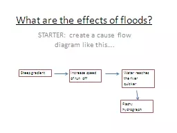
Slide2Shoal Creek Detention Pond
Q: Can rain gardens replace pond?
MOPAC
Far West Blvd
Shoal Creek
Slide3Lidar to DEM
High
Low
ArcGIS
Help page “
Lidar
to raster”
Slide4Stream Lines and
Flow Accumulation
MOPAC
Far West Blvd
AGREE
50 ft
15 ft
Slide5Delineate Watershed
Far West Blvd
Area = 107 acres
Slide6Single Family Homes
Slide7Revised Question
Can rain gardens provide flood control for commercial property?
CivicMulti-family
Office
Roads
Slide8Assumption
Pond
=
Rain Gardens
Σ
time
cfs
Pond
Vol
=
Σ
(Rain Garden
Vol
)
Slide9Pond Volume:
Cut and Fill Tool
DEM
Artificial DEM
Cut
Cut
Fill
Fill = Pond Vol = 2.06 x 10⁶ cubic feet
Weir
Pond
Slide10Rain Garden Design
Soil Porosity = 0.2
4 in.
30 in.
10 in.
1.25 in.
Equivalent
Storage
Depth
Slide11Feasibility Assessment
=
Pond VolEquivalent RG Depth
Rain Garden Area
=
RG Area
Watershed Area
53%
=
Pervious Cover
Per Lot56%
?
=5757
107=Acres
Slide12Conclusions
Can rain gardens replace pond? Tentative No
Consider other optionsPervious pavingRoof top gardensMore complex RG designsRemaining questions
MaintenanceWater quality from roads