
about 1000 m48 hrs Thus they usually evaporate quickly upon leaving the cloud mass For it to fall as a raindrop the cloud droplet must get bigger One raindrop about 1 million cloud droplets ID: 1021185
Download Presentation The PPT/PDF document "The average size of a cloud droplet is a..." is the property of its rightful owner. Permission is granted to download and print the materials on this web site for personal, non-commercial use only, and to display it on your personal computer provided you do not modify the materials and that you retain all copyright notices contained in the materials. By downloading content from our website, you accept the terms of this agreement.


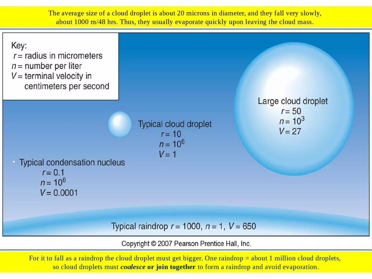
1. The average size of a cloud droplet is about 20 microns in diameter, and they fall very slowly, about 1000 m/48 hrs. Thus, they usually evaporate quickly upon leaving the cloud mass. For it to fall as a raindrop the cloud droplet must get bigger. One raindrop = about 1 million cloud droplets, so cloud droplets must coalesce or join together to form a raindrop and avoid evaporation.
2. A cloud may consist entirely of liquid water droplets, entirely of ice crystals or a combination depending on the temperature. Temperature will also determine the type of precipitation that falls (rain, snow, sleet or freezing rain) from the cloud and in what form it is when it hits the ground.
3. Cirrus clouds are composed of ice crystals and do not produce precipitation.
4. The cloud mass of a thunderstorm will have ice crystals in the upper levels and liquid water droplets in the lower levels, still dependent on T°. It may produce rain, snow, sleet, or freezing rain.
5. The Bergeron or ice-crystal Process is the primary process for forming precipitation in the middle and high latitudes and the only process to form snow. The basic process is water vapor changing to ice crystals by deposition, and the ice crystals join with other ice crystals to make snow crystals and then snowflakes. If they melt while falling, then they become a raindrop.
6. Snow cover after a storm in China, 2008.
7. Bergeron Process of ice crystal formation (left) and Collision-Coalescence Process ofraindrop formation (right).
8. Collision-Coalescence Process is the primary process in tropical areas for raindrop formation and in mid-latitudes during the summer.The basic process is water vapor changing to liquid water droplets(cloud droplets) by condensation, and these droplets coalescingwith other droplets to form raindrops.
9. For a cloud droplet/raindrop to hit the ground, it must be large enough to overcome evaporation. By joining with other droplets and/or raindrops (coalescence) it can achieve the sufficient size.
10. Raindrops initially are spherical and then flatten on the bottom as they fall. But because of frictionand drag forces they will get no larger than about 5mm in diameter before they are torn apart.
11. Bergeron Process of ice crystal formation (right) and Collision-Coalescence Process of raindrop formation (left).
12. Rain can be the result of the Collision-Coalescence or the Bergeron Process. If the precipitation is liquid when it leaves the cloud and stays liquid to the ground, then it is rain. If it leaves the cloud as a snowflake and then melts before hitting the ground, it is rain.
13. This thunderstorm may form precipitation as rain or snow, dependent on the state of matter (solid or liquid) as it hits the ground. The precipitation may leave the cloud mass as liquid or solid, but its state of matter when it hits the ground determines the type of precipitation it is classified.A cumulonimbus cloud (thunderstorm) is one of only two cloud types which form precipitation.
14. A Nimbostratus cloud is the other type of cloud which forms precipitation. Both types, nimbostratus and cumulonimbus, may produce rain, snow, sleet, or freezing rain.
15. The Bergeron Process of precipitation formation is the only process which can form snow. For precipitation to be classified as snow it must start as an ice crystal, grow to a snowflake and stay a snowflake all the way to the ground. A raindrop will not turn into a snowflake. A snowflake can turn into a raindrop by melting though.
16. Ice crystals can assume several general shapes such as dendrites (a), plates (b) and columns (c).
17. Snowflakes come in many shapes and based on what we know of how they form, theoretically no two snowflakes are exactly alike.
18. Snow crystals (left) magnified using a scanning electron microscope anda snowflake (right) magnified using a conventional microscope.
19. When measuring snow for precipitation total amounts, it is converted into inches of rain, but one inch of snow does not equal one inch of rain. The average conversation rate is ten inches of snow equals one inch of rain.
20. The average annual snowfall varies by latitude, location relative mountains, water bodies, etc. Lake-effect snow is a major concern in places like Buffalo, NY (USA) seen here.
21. Chicago blizzard of Feb. 01, 2011. Like with most weather events, some years see more than others (more hurricanes, more rain, more snow, etc.)
22. Sleet is essentially a frozen raindrop. If it starts as a snowflake (Bergeron Process), then it melts to form a raindrop that then re-freezes before it hits the ground. As the snowflake falls it passes through air which is at a T° above 32° F, melts becoming a raindrop, which then passes through colder air (<32° F) again and re-freezes.Sleet formation in this area.
23. Sleet pellets or frozen raindrops, will essentially be the same size as the raindrop. These form differently than hailstones.
24. Freezing rain is like sleet except it freezes (re-freezes) after contacting the ground. The colder air through which the raindrop falls is not thick enough for it to re-freeze in the air (red arrows). This usually involves supercooled raindrops which allows them to freeze on contact with solid objects/surfaces. Commonly referred to as Ice storms.Freezing rain would form in this area.Sleet formation in this area.
25. The result of a freezing rain event leaves the grass and other surfaces covered in a layer of ice.
26. The result of a freezing rain event leaves a layer of ice on surfaces like this car, tree, driveway, road, etc.
27. Ice coats trees, powerlines, telephone lines, etc. after a freezing rain event.
28. Ice coats trees after a freezing rain event. The thicker the ice layer, the more damage that is sustained.
29. Hailstones are formed as they move up and down in a thunderstorm due to the movement of updrafts and downdrafts. As an ice pellet is pulled up by an updraft it is coated with more liquid water which freezes as it gets higher in the cloud. It is pushed down by a downdraft, then up again and so on until the hailstone is too big to be suspended any longer.Hail is another form of solid precipitation consisting of hard, round pellets or lumps of ice. They are only produced in large cumulonimbus clouds, thunderstorms, and primarily only in the summer.
30. Hailstones, some of which are about golf ball size.
31. Unlike sleet and freezing rain, hail is primarily a summertime phenomena. And like sleet and freezing rain, it is not typically counted in precipitation totals.
32. Here can be seen the layering of a hailstone, like the rings of a tree.
33. Sometimes one hailstone is several hailstones that have coalesced.
34.
35. This is one of the largest hailstones ever reported and the largest ever purported in Nebraska (USA).
36. Hail events are most numerous in the Great Plains of North America.
37.
38.
39. Two types of rain gauges used to measure rain event totals.
40. Air Pressure systems greatly affect precipitation patterns with areas of Low Pressure (i.e., ITCZ) typically being unstable thus producing more precipitation and areas of High Pressure (i.e., STH) typically being stable and less precipitation.
41. Worldwide average annual precipitation. The band of darker blue lies along the ITCZ and the tan areas are associated with STH cells.
42. Sub-Tropical High-Pressure cells (STHs) that sit over oceans, don’thave the same characteristics on both the east and west side.The East Side (African-Europe side in this diagram) exhibits the typical stable, dry conditions of a STH.While the West Side (U.S. side in this diagram) exhibits unstable, wetter conditions.
43. Rain Shadow Deserts are formed by mountain barriers and orographic effects such that the leeward side (right side in this diagram) is often much drier than the windward side (left side in the diagram).
44. Areas such as the Great Basin and Death Valley (darker brown shade on the map) are the result of rain shadow effects.
45. The Monsoon is an annual cycle of dryness and wetness, with seasonally shifting winds produced by shifting atmospheric pressure patterns. In winter (left map) there is High-pressure over China and Low-pressure over the Indian Ocean, so winds are a giant, dry land breeze. In summer, this pattern is reversed, and a giant, wet sea breeze develops. (Winds flow from High to Low pressure.)
46. Winter monsoon pattern.
47. Summer monsoon pattern.