
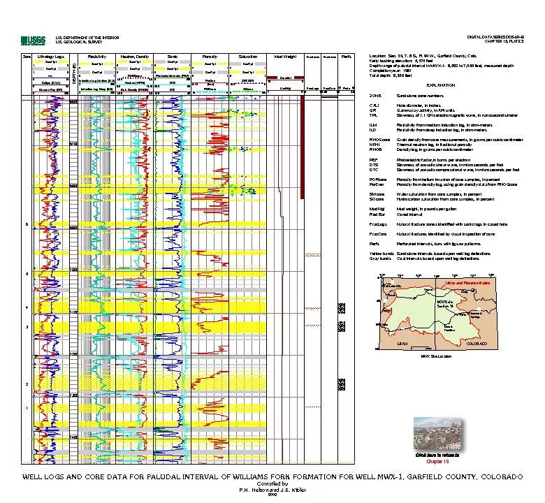
Zone Gamma Ray GR 0 200 Caliper CALI 8 24 TPL 4 14 CoalTpl 1 0 SandTpl 1 0 DEPTH ft 6600 6700 6800 6900 7000 7100 7200 7300 7400 Resistivity Induction Log Deep ILD 2 200 Induction Log Medium ID: 133784
Download Pdf The PPT/PDF document "Lithology Logs" is the property of its rightful owner. Permission is granted to download and print the materials on this web site for personal, non-commercial use only, and to display it on your personal computer provided you do not modify the materials and that you retain all copyright notices contained in the materials. By downloading content from our website, you accept the terms of this agreement.


Zone Lithology Logs Gamma Ray (GR) 0 200 Caliper (CALI) 8 24 TPL 4 14 CoalTpl 1 0 SandTpl 1 0 DEPTH (ft) 6600 6700 6800 6900 7000 7100 7200 7300 7400 Resistivity Induction Log Deep (ILD) 2 200 Induction Log Medium (ILM) 2 200 CoalTpl 0 1 SandTpl 0 1 Neutron, Density Bulk Density (RHOB) 1.65 2.9 Neutron (NPHI) 0.6 -0.15 RHOGcore 1.65 2.9 CoalTpl 0 1 SandTpl 0 1 Sonic DTC 140 40 DTS 280 80 Photoelectric factor (PEF) 0 100 SandTpl 0 1 CoalTpl 0 1 Porosity PORcore 15 0 PorDen 0.15 (frac) 0 CoalTpl 0 1 SandTpl 0 1 Saturation SOcore 0 100 SWCORE 100 0 SandTpl 0 1 CoalTpl 0 1 Mud Weight MudWgt 7 17 CoredInt 10 0 Fractures FracLogs 0 1 Fractures FracCore 0.99 1 Perfs Perfs 0 2.5 6 5 4 3 2 1 Location: Sec. 34, T. 6 S., R. 94 W., Garfield County, Colo. Kelly bushing elevation: 5,374 feet Depth range of paludal interval in MWX-1: 6,592 to 7,455 feet, measured depth Completion year: 1981 Total depth: 8,350 feet \t \t \t \t \t \t \t \t \t \t \t \t EXPLANATION ZONE \t \t Sandstone zone numbers CALI\t \t \t \t Hole diameter, in inches GR \t \t \t Gamma ray activity, in API units TPL\t \t \t \t Slowness of 1.1 GHz electromagnetic wave, in nanoseconds/meter ILM \t \t \t Resistivity from medium induction log, in ohm-meters ILD \t \t \t \t Resistivity from deep induction log, in ohm-meters RHOGcore\t \t Grain density from core measurements, in grams per cubic centimeter NPHI\t \t \t \t Thermal neutron log, in fractional porosity RHOB \t \t Density log, in grams per cubic centimeter PEF\t \t \t \t Photoelectric factor,in barns per electron DTS\t \t \t \t Slowness of acoustic shear wave, in microseconds per foot DTC\t \t \t \t Slowness of acoustic compressional wave, in microseconds per foot PORcore \t Porosity from helium invasion of core samples, in percent PorDen\t \t \t Porosity from density log, using grain density data from RHOGcore SWcore\t \t \t Water saturation from core samples, in percent SOcore\t \t \t Hydrocarbon saturation from core samples, in percent MudWgt\t \t \t Mud weight, in pounds per gallon Red Bar\t \t \t Cored interval FracLogs \t Natural fracture zones identified with sonic logs in cased hole FracCore \t Natural fractures identified by visual inspection of core Perfs\t \t \t \t Perforated intervals, bars with jigsaw patterrns Yellow bands\t Sandstone intervals based upon well log deflections Gray bands Coal intervals based upon well log deflections U.S. DEPARTMENT OF THE INTERIOR U.S. GEOLOGICAL SURVEY DIGITAL DATA SERIES DDS–69–B CHAPTER 15, PLATE 3 WELL LOGS AND CORE DATA FOR PALUDAL INTERVAL OF WILLIAMS FORK FORMATION FOR WELL MWX-1, GARFIELD COUNTY, COLORADO Compiled by P.H. Nelson and J.E. Kibler 2002 MWX Site Location 15 80 70 Glenwood Springs Craig Rifle Grand Junction Vernal Salt Lake City Provo Uinta and Piceance Basins 39° 38° 40° 41° 109° 110° 111° 112° 108° 107° 106° 40 40 0 50 Miles UTAH COLORADO 70 70 MWX site Section 34 Nephi Salina Chapter 15 WELL LOGS AND CORE DATA FOR PALUDAL INTERVAL OF WILLIAMS FORK FORMATION FOR WELL MWX-1, GARFIELD COUNTY, COLORADO Compiled by P.H. Nelson and J.E. Kibler 2002 U.S. DEPARTMENT OF THE INTERIOR U.S. GEOLOGICAL SURVEY DIGITAL DATA SERIES DDS–69–B CHAPTER 15, PLATE 3 Chapter 15