

Presenter Camille H Dwyer Contributors Dr Sam Hampton Dr Darren Gravley and Ben Chiewphasa T14 Geologic Hazards in Archaeological Contexts Wednesday 30 October 2013 1015 AM ID: 691516
Download Presentation The PPT/PDF document "The Stories of Banks Peninsula: Connecti..." is the property of its rightful owner. Permission is granted to download and print the materials on this web site for personal, non-commercial use only, and to display it on your personal computer provided you do not modify the materials and that you retain all copyright notices contained in the materials. By downloading content from our website, you accept the terms of this agreement.


Slide1
The Stories of Banks Peninsula: Connecting Maori Oral Traditions, European History, and Geological and Ecological Perspectives
Presenter: Camille H. Dwyer Contributors: Dr. Sam Hampton, Dr. Darren Gravley, and Ben Chiewphasa “T14. Geologic Hazards in Archaeological Contexts,”Wednesday, 30 October 2013, 10:15 AMSlide2
Outline
Introduction to Banks Peninsula and the Maori Main Question
MethodsHistorical, Geological, Archaeological, and Anthropological Evidence Surrounding TsunamisPa LocationsRemaining Questions and SignificanceSlide3
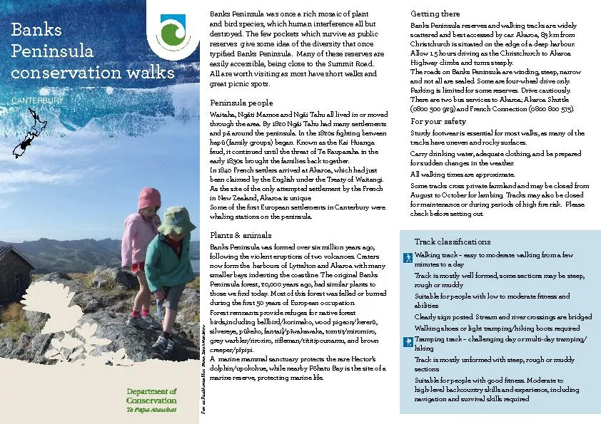
Banks Peninsula, New Zealand
Figure Adapted from Hampton (2012)Slide4
Maori of New Zealand
First inhabitants arrived
to North Island ~ 13th century C.E. (Te Ara, 2013).Banks Peninsula inhabited by 2 iwi (tribe), the Waitaha & Ngati Mamoe ~ 14th to 16th century (Bassett et al. 2004 & Stack, 1893).
Early 1600s, Maori iwi, Ngāi Tahu settled in Banks Peninsula (Te Maire Tau, 2012)
http
://www.teara.govt.nz/files/32146-wmu.jpgSlide5
Pa = Fortified Settlement
Photo: http
://theprow.org.nz/assets/Maori/Taupo-pa.jpgSlide6
Do Maori settlement patterns on Banks Peninsula reflect an understanding of and response to naturally occurring phenomena such as tsunamis and their associated hazards?
Photo Courtesy of
Paula Bürgi- Pa Bay Slide7
Methods
Understand the European h
istorical and scientific perspectives Interpret oral traditionHistorical and Symbolic
Interviews with kaitiaki (guardian/ elder) from Ōnuku
Marae in Akaroa Harbour and Maori Resources Librarian, NekenekeiteRangi PaulSlide8
Maps of pa sites (Taylor, 1894; Challis, 1995)
To understand the geological landscape consulted Google Earth and The Tattooed Land: The Southern Frontiers of the Pa Maori (Brailsford, 1981)
Photo Courtesy of Paula Bürgi- Pa Island
Methods ContinuedSlide9
Tsunami Evidence
HistoryGeologyArchaeology
Oral Tradition:TaniwhaPa of Nga-Toko-Ono
Photo Courtesy of
Paula Bürgi
- Pa IslandSlide10
European Historical Evidence
http://
media.treehugger.com/European Historical examples include: 1868 and 1960Slide11
Natural Hazards
1868 Tsunami impact on Okains Bay Bridge
http://christchurchcitylibraries.com/heritage/maps/169109.jpgSlide12
Record of 7
paleotsunamis
(Goff & Chagué- Goff, 2012). Only concerned about 1250 -1350 C.E. and 1604 C.E.Scientific EvidencePhoto Courtesy
of Jane Eisenberg- WakaSlide13
Scientific Evidence
Geological Evidence: Tsunami Deposit Couplets from Okains Bay
Figure Adopted from Goff and Chagué- Goff (2012)
Archaeological Evidence: Inhabited Cave Slide14
Taniwha = Giant Sea Lizard
http://www.worth1000.com/contests/21347/cryptozoo-8Slide15
Pa of Nga
-Toko-Ono and Chatham Islands
Figure Adopted From Stevens & Chiswell (2012) Slide16
B
iggest threat to
New Zealand’s east coast are transoceanic tsunamis triggered by high magnitude South American earthquakes.Tsunami effects are greater on Northern and Eastern Banks Peninsula.
Photo Courtesy of
Kyle Metcalfe- Banks PeninsulaSlide17
Pas of Banks Peninsula
Figure
Modified
from Challis (1995
)
Elevation: Tsunami Risk
Low Elevation: High
Combination: Medium
High Cliffs: Minimal
Low Elevation: NoneSlide18
Lingering Questions
Did
the Ngāi Tahu move to Banks Peninsula after the 1604 C.E. tsunami to look for more natural resources as well as higher ground to construct pas because of another impending tsunami event?Photo Courtesy of Kyle Metcalfe- Waitangi DaySlide19
Research Significance
When there is not an obvious geological record, researchers can use oral traditions to supplement and enhance it.
Learning from the past can help modern day Kiwis become aware of transoceanic tsunamis and their associated hazardsPhoto Courtesy of Paula B
ürgi-East Okains BaySlide20
Summary
Maori and Banks PeninsulaMain Question
Read articles, interpreted oral traditions, and consulted mapsEuropean perspectives, Geological, Archaeological, and Oral Traditions for tsunami evidenceEast coast pas reflect understanding, but north coast pas do not.
Oral Traditions can help to supplement the geological recordSlide21
Questions
Photo Courtesy of Alexa Zilberfarb - Akaora Harbour
cdwyer@smith.edu