
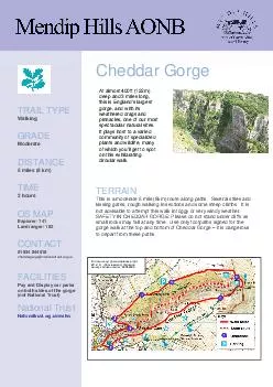
Several stiles and kissing gates rough walking in sections and some steep climbs It is not advisable to attempt this walk in foggy or very windy weather SAFETY IN CHEDDAR GORGE Please do not stand under cliffs as small rocks may fall at any time Use ID: 41233
Download Pdf The PPT/PDF document "Cheddar Gorge TERRAIN This is a moderate..." is the property of its rightful owner. Permission is granted to download and print the materials on this web site for personal, non-commercial use only, and to display it on your personal computer provided you do not modify the materials and that you retain all copyright notices contained in the materials. By downloading content from our website, you accept the terms of this agreement.


Cheddar Gorge This is a moderate 5 mile (8km) route along paths. Several stiles and kissing gates, rough walking in sections and some steep climbs. It is not advisable to attempt this walk in foggy or very windy weather. SAFETY IN CHEDDAR GORGE: Please do not stand under cliffs as small rocks may fall at any time. Use only footpaths signed for the gorge walk at the top and bottom of Cheddar Gorge it is dangerous Explorer: 141 Landranger: 182 01934 844518 cheddargorge@nationaltrust.org.uk Pay and Display car parks on both sides of the gorge (not National Trust) Nationaltrust.org.uk/walks deep and 3 miles long, this is Englands largest pinnacles, one of our most spectacular natural sites. It plays host to a varied community of specialized plants and wildlife, many of which youll get to spot © Crown copyright and database right 2012. All rights reserved. Ordnance Survey License number 100052600.