
ScaleMaster multiscale design decisions Categories of design change Content Add Features C Eliminate Features C Reclassify Features Cc Reorder Features Co ID: 622540
Download Presentation The PPT/PDF document "2011" is the property of its rightful owner. Permission is granted to download and print the materials on this web site for personal, non-commercial use only, and to display it on your personal computer provided you do not modify the materials and that you retain all copyright notices contained in the materials. By downloading content from our website, you accept the terms of this agreement.


Slide1
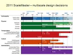
2011 ScaleMaster – multiscale design decisionsSlide2
Categories of design changeContentAdd Features (C+)Eliminate Features (C-)Reclassify Features (Cc)Reorder Features (Co)Labeling
Add Labels (
L+
)Eliminate Labels (L-)Adjust Appearance (La)Adjust Position (Lp)
GeometryAggregate (Gg)Collapse (Gc)Displace (Gd)Exaggerate (Gx)Merge (Gm)Simplify (Gs)Smooth (Go)GC – replace with generalized dataset
SymbolAdjust Color (Sc)Enhance (Se)Adjust Pattern (Sp)Rotate (So)Adjust Shape (Ss)Adjust Size (Sz)Adjust Transparency (St)Typify (Sf)
Roth et al., 2011, Cartographic PerspectivesSlide3
In Progress
New terrain recommendations from Andy StaufferSlide4
In Progress
Road thinning from Larry+,
TeleAtlas
or TIGER?Slide5
In Progress
Airport shape database--IDs, join to FAA data on flight numbers
Need rail hierarchySlide6
In Progress
Need hierarchy on GNIS points, structures (17 types)Slide7
In Progress
Ongoing
placename
hierarchy research (TNM
UC, ICA Workshop)Slide8
In Progress
Landcover
resolution, overlay with adminSlide9
What’s not in ScaleMaster yetOrtho imagery through scaleGrids, coordinates, PLSS… through scaleCoordinate land cover and related admin boundariesWooded and forest reservesBuilt up areas and incorporated place boundaries, CDPsSlide10
Data development needs from othersAreas for GNIS point names: physical features (bay, valley…), building complexes (large hospital, campus…)More hierarchiesRoadsStructures (for 17 types in standard)AirportsRailSummits (importance vs elevation threshold or relief analysis)
To>