Please download the presentation after appearing the download area.
Download - The PPT/PDF document "Lower Lamoille Wildlife Management Area" is the property of its rightful owner. Permission is granted to download and print the materials on this web site for personal, non-commercial use only, and to display it on your personal computer provided you do not modify the materials and that you retain all copyright notices contained in the materials. By downloading content from our website, you accept the terms of this agreement.
Embed / Share - Lower Lamoille Wildlife Management Area
Presentation on theme: "Lower Lamoille Wildlife Management Area"— Presentation transcript
1Lower Lamoille Wildlife Management Area Lower Lamoille Wildlife Management Area
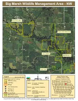
General Description
mostly of silver and red maple and green ash. A few upland acres are regenerating old fields. Common plants include cattail, wild rice, and red and silver maple.
Lower Lamoille River Wildlife Management Area (WMA) is located in northwest Vermont in the town of
Lower Lam
History
The Lamoille River was an important travel corridor for Native Americans. They hunted here and fished for pike. The name Lamoille may be a misspelling of the name Samuel de Champlain suppos
This is a relatively new WMA, acquired with the assistance of The Nature Conservancy in 1995. Vermont Duck Stamp monies were used in part. The State also received a grant from the North American Wetland Conservation Act and a private donation.
Habitat Features
Common Fish and Wildlife
Mammals There are white-tailed deer on the upland portions of the WMA. Wetland dwelling mammals occurring here include
Birds Wetland and wetland edge birds may be found here. Waterfowl are common during breeding and migration, especially mallards and wood ducks. Marsh birds such as herons, rails, bitterns and marsh wrens may be seen or heard. Ru
Reptiles and Amphibians Several herptiles may found in the WMA including eastern newts, red-backed salamanders, mudpuppies, and northe
2rn leopard, green and bull frogs. Snappi rn leopard, green and bull frogs. Snapping, painted, wood and northern map turtles may be seen sunning themselves on logs. Northern
Fish There is good fishing for northern pike, smallmouth bass and walleye in the Lamoille River nearby. The WMA itself has limited fishing.
Water lilies float on the Lower Lamoille River oxbow. Bill Crenshaw, VFWD photo.
""""""""""""""""""""""""""""""""""""""""""""""""""""""""""""""""""""""""""""""""""""""""""""""""""""""""""""""""""""""""""""""""""""""""""""""""""""""""""""""""""""""""""""""""""""""""""""""""""""""""""""""""""""""""""""""""""""""""""""""""""""""""""""""""""""""""""
Æî
!
SandbarWMARoundPond
J$$
!!
89W MILTON RDWATKINS RDBEAR TRAP RDJASPER MINE RDMAYO RDCHIMNEY HILL DRJACKSON LNLACASSE DR
Lamoille River
200300200200200200200200
Milton
Colchester
444500
444500
445000
445000
445500
445500
446000
446000
446500
446500
447000
447000
233500
233500
234000
234000
234500
234500
235000
235000
235500
235500
236000
236000
Vermont Fish & Wildlife DepartmentLower Lamoille River Wildlife Management Area
0.250.50.125MilesThis map is for illustrative purposes only. The accuracy of the datalayers shown on this map are limited by the accuracy of the sourcematerials. No warranty as to the accuracy or the usefullness of thedata is expressed or implied.
Lower Lamoille River WMA: 234 acresWildlife Viewing AreasDesignated Camp SiteDuring Big Game Seasons OnlyParking
%$GateCar-top AccessBoat Ramp
Wildlife Management Area
Other Public Land
Private w/ Public Acces