

Lesson 6 What is the MJO Largescale disturbance of deep convection and winds that controls up to half of the variance of tropical convection in some regions Now known to be a major propagator of weather systems ID: 675510
Download Presentation The PPT/PDF document "SO442 – the Madden-Julian Oscillation" is the property of its rightful owner. Permission is granted to download and print the materials on this web site for personal, non-commercial use only, and to display it on your personal computer provided you do not modify the materials and that you retain all copyright notices contained in the materials. By downloading content from our website, you accept the terms of this agreement.


Slide1
SO442 – the Madden-Julian Oscillation
Lesson 6Slide2
What is the MJO?
Large-scale disturbance of deep convection and winds that controls up to half of the variance of tropical convection in some regions
Now known to be a major propagator of weather systemsSlide3
Space and time-scales of dynamical atmospheric processes. SOURCE: UCAR
Climate
: PDO
Years
: ENSO
Seasons:
Monsoons
Months/Weeks:
MJO
Atmospheric Scales of MotionSlide4
The Madden-Julian Oscillation (MJO)
Important features:
Convectively coupled disturbance that propagates eastward across the Tropics
5-10 m s
-1
propagation speed in the Indian and west Pacific, where MJO convective variability is strongly coupled to the large-scale flow.Simple baroclinic wind structure, with 850 hPa and 200 hPa wind perturbations 180o out of phaseCharacteristic timescales of 30-90 days.
Madden and Julian 1972
Univ of Munich Physics DeptSlide5
MJO- an intraseasonal event
Prior to 1971, it was thought that virtually all variability in the weather conditions within a given season in the Tropics was random.
There were indications of interseasonal variations, such as the Southern Oscillation
Studies of Tropical rainfall and pressure changes showed additional oscillationsSlide6
The MJO - A Description
A 30-60 day oscillation in the coupled Tropical ocean-atmosphere system
An eastward progression of enhanced and suppressed convection
Low level and upper level wind patterns show distinct anomalies
Strong year to year variability in MJO that is related to ENSO cycleSlide7
MJO Structure in Outgoing Longwave Radiation (OLR):
Indian Ocean and Western Pacific, Phases 1-8
convective anomaly subsidence anomaly
convective
component
subsidence
component
1
2
3
4
5
8
7
6Slide8
climate.gov
MJO is a very large scale oscillation (approximately 15,000 km east-west distance)
Centered on the equator
Features: one region of upward motion (favoring convection) and one region of downward motion (favoring drier conditions)
Note: in this graphic, the MJO is
not
one thunderstorm that covers an entire ocean. Such a thing doesn’t exist! Rather, in the region represented by the cloud, MJO favors the development of more thunderstorms than normalSlide9
MJO couplet (one region of upward motion and one region of downward motion) moves eastward along the equator
Why does it move along the equator, and not off the equator?
MJO really is an “equatorally trapped” Kelvin wave
Coriolis force acts to trap the MJO wave along the equator
Over a 3-5 week period, the MJO convective couplet can transit the tropical eastern hemisphereSlide10
Univ of Washington Atmos Sci dept
NOAA Pacific Northwest Laboratory (PNL)
US Dept of Energy
More views of the MJO convective couplet – not just thunderstorms but also specific humidity and wind anomalies, too!
The passage of the MJO across the tropical oceans also shows up in SST anomaliesSlide11
MJO Cluster Structure
Jon Gottschalck, NOAA Climate Prediction Center Slide12
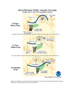
MJO Forecasting
Jon Gottschalck, NOAA Climate Prediction Center Slide13
MJO Forecasting
NOAA Climate Prediction Center Slide14
How MJO was discovered
In the 1960s and 1970s, new computer power created the ability to look for patterns in meteorological observations.
Could only look for patterns in TIME (at a location), not SPACE (at a given time).
Tended to detect OSCILLATIONS.Slide15
What They Found
Surface pressure oscillates with a period of 40-50 days.
ZONAL winds in the lower and upper troposphere also oscillate at this frequency, but 180° out-of-phase.
The signal was limited to the deep tropics.
They found little signal in the meridional wind, or in zonal winds in the midtroposphere.Slide16
Evidence of MJOs
Sea Level Pressure, Equator and 180E, May – Oct 1979
Figure from R. Madden, 31 Aug 2005
45 daysSlide17
Evidence of MJOs
Temperature, Upper Ocean, Equator and 155W, Aug 1991 – Jul 1992
45 days
T 125 m
T 150 mSlide18
Their Interpretation
MJO is a region of low-level convergence and convection.
Propagating eastward only.
Circumnavigates the globe in 40-50 days.Slide19
Their Interpretation
Pressure is LOW in the region of strongest convection.
Upper-level outflow is only in the zonal direction.Slide20
Kelvin Waves in the OceanSlide21
Convective Kelvin Wave
H
L
Convection removes
Some of the accumulating
mass, slows propagation
Propagation speed: less than 20 ms
-1
z
xSlide22
Kelvin Waves in the AtmosphereSlide23
Kelvin Waves in the Atmosphere
ConvectionSlide24
Features:
Enhanced tradewinds AHEAD of the convection.Slide25
Features:
Weak tradewinds—maybe even westerlies—behind the convection.Slide26
Features:
Alternating areas of high and low pressure.
H
L
HSlide27
Features:
Alternating areas of high and low OLR values!
H
L
HSlide28
Features:
Notice that there shouldn’t be much signal in the midtropospheric winds!Slide29
Features:
An area of upper-tropospheric DIVERGENCE, best seen in the VELOCITY POTENTIAL.Slide30
Circumnavigating the Globe?
Madden and Julian originally believed that this area of convection propagated all the way around the world every 40-50 days.
But this isn’t exactly right.Slide31
Circumnavigating the Globe?
Rather, the convection is TRIGGERED in the eastern Indian Ocean (typically by intruding midlatitude systems).
Convection dies out in the eastern Pacific due to cold SSTsSlide32
Circumnavigating the Globe?
However, the region of upper-level divergence WILL generally travel all the way around the world as a Kelvin Wave.Slide33
Kelvin Waves and the Walker CirculationSlide34
Kelvin Waves and the Walker Circulation
Initially OPPOSES the Walker Circulation
Later ENHANCES the Walker Circulation!Slide35
Kelvin Waves and the Walker Circulation
Later, it OPPOSES the Walker Circulation and the trade winds in the Pacific!Slide36
Kelvin Waves and the Walker Circulation
However, these tradewinds are what maintained the high sea surface temperatures and heights of the western Pacific Warm Pool…Slide37
El Nino and the MJO
MJO events can
TRIGGER
El Nino events by weakening the trade winds (or even having a WESTERLY WIND BURST).Slide38
El Nino and the MJO
Why doesn’t EVERY MJO trigger an El Nino event?
CHARGE/DISCHARGE THEORY:
MJO is the TRIGGER—it happens much more often than the El Nino event itself.
Not every trigger is exactly right.
Even when the trigger is right, maybe ocean conditions are not yet right.A partial explanation for the timing of ENSO.Slide39
Triggering MJO Events
An MJO event in the Indian Ocean upsets the SSTs.
It takes time for the SSTs to recover.
Any intruding midlatitude systems during this period will FAIL to trigger an MJO event.
Only when the environment is ready (another 40-50 days) will the next midlatitude system be able to trigger a new MJO!Slide40
What are
MJO events?
Described by “Nakazawa’s Hierarchy of Convection”Slide41
What are
MJO events?
Each MJO event is actually composed of a small number of “super cloud clusters”--SCCsSlide42
What are
MJO events?
SCCs:
Move EASTWARD
Last a day or twoSlide43
What are
MJO events?
What are SCCs?
Made of Cloud Clusters (CCs)Slide44
What are
MJO events?
What are CCs?
Small groups of thunderstorms
Last less than a day
Move WESTWARDSlide45
1 MJOSlide46
4 SCCsSlide47
Many CCsSlide48
OBSERVATIONS OF KELVIN WAVES AND THE MJO
Time–longitude diagram of CLAUS T
b
(2.5S–7.5N), January–April 1987
Kelvin
waves
(15 m s
-1)
MJO event from Feb-Mar 1987 seen as cluster of Kelvin waves. Other Kelvin waves were also seen in March & April that were not really part of MJO
MJO
(5 m s
-1)Slide49
OLR power spectrum, 1979–2001 (Symmetric)
from
Wheeler and Kiladis, 1999
How did we know that the cloud clusters in the previous slide were MJO and Kelvin waves? We could calculate their periods and zonal wavenumbers and identify them in this power spectrum diagramSlide50
Overview of Madden-Julian Oscillations (MJOs)
major and complex disturbances of the global
tropical atmosphere-ocean system
propagating intraseasonal (~ 1-2 months) oscillations
usually start in tropical Indian - W Pacific regionhave largest amplitude in tropical Indian - Pacific regionpropagate E-ward through the tropicsmay propagate around globe, especially as UL disturbanceperiod
30-60 days 45 dayszonal wave length Earth’s circumferenceoccur throughout the yearmay have large impacts on global tropics and extratropicshave impacts on midlatitude climate
strong atmosphere-ocean coupling makes them difficult to analyze and model Slide51
= positive heating
anomaly
= energy propagation
through wave train
Modeled Tropospheric Response to Western Tropical Pacific
Positive Heating Anomaly in Northern Winter
MJOs and Teleconnections
H
H
H
L
L
=
dry air advection
=
moist air advectionSlide52
MJOs and Teleconnections
Figure from: http://www.cpc.ncep.noaa.gov/products/intraseasonal/intraseasonal_faq.html#what
cf. Higgins and Mo, J Clim, 1997
Relationships Between Propagating Tropical Positive Convection Anomaly and North Pacific – North American Circulation and Precipitation AnomaliesSlide53
Z 200 Anomalies, Dec 1996 – Jan 1997
MJOs and Teleconnections
During Dec 96 - Jan 97:
Weak La Nina conditions in tropical Pacific
Intense MJO activity in Indian Ocean – western tropical Pacific
Anomalously heavy precipitation and flooding in N CA, OR, WA
Anomalously low precipitation in SW US
Extratropical wave train similar to expected for MJO convection in
tropical E IO – W Pacific
Other examples of MJO impacts on west coast precipitation?
Jan 92, Feb 93, Jan 95, Oct–Nov 03, Dec 04 – Jan 05, Dec 05 - Jan 06Slide54
NPNA response to MJO affected by season. Effects can be dramatic. Likely causes: seasonal changes in location of convection and subsidence, and in strength, location, shear of east Asia - North Pacific jet.
OND
JFM
ONDJFM
Composites for: Phase 3, All Amplitudes, and all Background States,
by Season
Slide55
Favorable / Unfavorable Conditions for MJO-Associated
Anomalously
Wet
Conditions in CA
Favorable
Unfavorable
1. Early or late phases of the MJO
2. OND or JFM3. El Niño or neutral background state 4. Wave train from Asia with anomalous
low north and west of CA5. Southwest to northeast tilt to the anomalous low off CA 1. La Niña background state2. Middle phases of the MJO
Favorable / Unfavorable Conditions for MJO-AssociatedAnomalously Dry
Conditions in CAFavorable
Unfavorable1. Middle or late phases of the MJO 2. JFM
3. La Niña background state4. Anomalous high over northeastern Pacific1. Early phases of the MJO 2. El Nino background state
Favorable and Unfavorable Factors for Wet and Dry Conditions in California
Corresponding results for PNW, BC, and AK regions (not shown)Slide56
The Satellite View of MJO
The MJO is noted by a cluster of thunderstorms drifting eastward along the equatorial Indian and Pacific oceans.Slide57
Simplified Madden-Julian Oscillation Composite
OLR from A.J. Matthews, 2000.Slide58
Formation
Region
Decay RegionSlide59
Active
ConvectionSlide60
Active
Convection
Enhanced
EasterliesSlide61
Active
Convection
Cold air outbreak enhancementSlide62
Active
Convection
Energy Build-up
Deflected
Jet StreamSlide63
MJO - A Modeler’s Nightmare
GCM simulation of convection (CPS)
SST variations not well simulated
Change of phase speed from eastern to western hemispheres
Handling of very low wave number
Recent modifications-increased vertical resolutionbetter parameterization of:radiationconvectioncloud formationprecipitationsurface convergenceSlide64
Theory: Moisture Modes and the MSE Budget
Peters and
Bretherton (2006)
A moisture mode instability can result if large-scale divergent motions associated with convection import MSE into the column (e.g. Raymond et al. 2009, negative gross moist stability)
Alternatively, export by divergent motions can be positive, but MSE sources such as latent heat flux and cloud-radiative feedbacks overcompensate to produce MSE increases as a result of convection.
Such instability is manifest for WTG as strong positive moisture-convection feedbacksSlide65
Madden-Julian Oscillation
(a.k.a. Intraseasonal, 40-50, 30-60 Day Oscillation)
Madden & Julian, 1972
1987/88
Intraseasonal Time Scale: ~40-60 days
Planetary-Scale: Zonal Wavenumbers 1-3
Baroclinic Wind Structure
Eastward Propagation
E. Hem: ~5 m/s, Surf.+Conv.+Circ. Interactions
W. Hem: ~ > 10 m/s, ~Free Tropospheric Wave
Tendency to be Equatorially Trapped Strong Seasonal Dependence: NH Winter: Eastward Propagation NH Summer: ~Northeast Propagation
Significant Interannual Variability Potential Role of Ocean/SST Feedback Convection Has Multi-Scale Structure Significant Remote and Extra-Tropical Impacts
U200
U850
Cloudy
Low OLR
Clear
High OLR
Rainfall
Typical Variables Used for MJO AnalysisSlide66
Composite rainfall maps derived from merged satellite and in-situ measurements are separated by 10 days.
Rainfall anomalies propagate in a eastward fashion and mainly affect the Tropical eastern hemisphere.
These anomalies are accompanied by anomalies in wind, solar radiation, sea surface temperature, etc.
A Typical
MJO in
N.H. WinterSlide67
Composite rainfall maps derived from merged satellite and in-situ measurements are separated by 10 days.
Rainfall anomalies propagate in a
northeast
fashion and mainly affect the Tropical eastern hemisphere.
These anomalies are accompanied by anomalies in wind, solar radiation, sea surface temperature, etc.
A Typical
MJO in N.H. Summer
1
2
3
4
5Slide68
Boreal Summer Complex Propagation & Multi-Scale Organization
Kemball-Cook & Wang, 2001
Eastward Propagating
Convective Envelope
~40-50 days
Northward Propagation
Of Rossby-Wave Convection
(twisting, SST, moisture feedback)
Westward Propagating
Rossby-Waves
~ 10-20 day;
Modulated by 40-50day
1
2
3
4
5