
By Conrad Ricks Liz Anderson Melissa Prater amp Michelle Carleton Source httpwwwbbccoukprogrammesb011vg9w Source httpcempakanatureblogspotcom200912indonesiasnextbigquakedueunderhtml ID: 377581
Download Presentation The PPT/PDF document "Sumatra 2004 Quake and Tsunami" is the property of its rightful owner. Permission is granted to download and print the materials on this web site for personal, non-commercial use only, and to display it on your personal computer provided you do not modify the materials and that you retain all copyright notices contained in the materials. By downloading content from our website, you accept the terms of this agreement.


Slide1
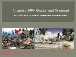
Sumatra 2004 Quake and Tsunami
By: Conrad Ricks, Liz Anderson, Melissa Prater & Michelle Carleton
Source: http://www.bbc.co.uk/programmes/b011vg9w
Source: http://cempaka-nature.blogspot.com/2009/12/indonesias-next-big-quake-due-under.htmlSlide2
Introduction
“On Sunday, 26 December 2004, the greatest earthquake in 40 years occurred about 150 kilometers off the west coast of northern Sumatra Island in Indonesia. The earthquake generated a disastrous tsunami that caused destruction in 11 countries bordering the Indian Ocean.”
- Dr. George Pararas-Carayannis
Source:http
://
www.sheppardsoftware.com
/
Asiaweb
/
factfile
/Unique-facts-Asia17.htmSlide3
Animation of 2004 Indonesia Tsunami
Press F5 for slide show to view animation.
Source:http
://en.wikipedia.org/wiki/File:2004_Indonesia_Tsunami_Complete.gifSlide4
BackgroundSlide5
Intensity on Mercalli
ScaleSlide6
Earthquake WavesSlide7
Tsunami Wave MapsSlide8
Causes of Earthquakes
The movement of plates along their boundaries is the cause of most earthquakes. The process of faulting (a surface sliding on another surface) causes friction which causes rocks to rupture along faults. This breaking and rupturing causes sudden movement which produce shock waves along the fault plane. This is the cause of earthquake belts like we see here.
Plate Tectonics and Boundaries
A rupture that propagated 1300-1600 km NW between the Indo-Australian plate and the Eurasian plate for around 10 minutes was the
cause
of the quake.
Source: http://cimss.ssec.wisc.edu/sage/geology/lesson2/concepts.html
Slide9
Measuring Earthquakes Magnitude
The moment magnitude scale allows scientists to measure the size of an earthquake and report it in some form of a decimal number. “[It] is determined from an estimate of the area that ruptured along a fault plane during the quake, the amount of movement or slippage along the fault, and the rigidity of the rocks near the focus of the quake.”
The Sumatra-Andaman quake was classified as a (MW) 9.2
Moment Magnitude Scale
Source: http
://www.kids-fun-science.com/moment-magnitude-scale.html
Slide10
Earthquake Intensity
Modified
Mercalli
Scale
Source:
http://www.sanandreasfault.org/feelit.html
retrieved Jan.30, 2012
The Modified
Mercalli
Scale is a tool used to measure the effects of an earthquake in a qualitative way. It uses Roman numerals to describe the intensity of the quake. The intensity can vary depending on how close you are to the epicenter of the quake.
In the Aceh Province shaking lasted for 5-6 minutes and would’ve been classified as VIII-IX Slide11
Epicenter
The epicenter is the location on the
earth’s surface above where the rocks ruptured (known as the hypocenter or focus) causing the quake.
The epicenter was about 250 km off the west coast of Aceh Province and the focus was 10 km deep.
Source:
http://today.caltech.edu/today/images/sumatra_05jan2005_02.jpg
Slide12
Aftermath
Tsunami
An earthquake will cause shifts in the surface due to the types of seismic waves that are released. As a result of this shift in the ocean floor, massive ocean waves can form and cause Tsunamis.
Source:
http://www.tsunamispecialenvoy.org/
The Tsunami waves that struck Aceh Province ranged from 4-39 meters high and destroyed more than 250 coastal communitiesSlide13
Other Effects
Landslides in Sumatra
Mud volcano Gas emissions Water level fluctuations
Effects of a single disaster can cause a handful of other disasters. Liquefaction, changes in land elevation, diseases and lack of natural resources are among a few of the effects that can occur.
Source:
http://en.wikipedia.org/wiki/Soil_liquefaction
Slide14
History
Previous Tsunamis in the Bay of Bengal 1881, 1883, 1907and 1941.
Previous Earthquake and Tsunami- 1881 and 1941. 1881 quake measured at (Mw) 7.9 with Tsunami waves around 1 m high.1941 quake measured at (Mw) 7.7 with waves around 1-1.5 m high.
Future ruptures for the area are possible. There is no historical data of the plate boundary just north of the Andaman Islands slipping. However, there is no evidence of a Quake or Tsunami of this size occurring for hundreds of years.
Source:
http://historiesofthingstocome.blogspot.com/2010/12/anniversaries-lest-we-forget-indian.html
Slide15
Minimizing Intensity
Be Prepared
Intensity from a natural disaster can be minimized if we take initiative and prepare for what could happen.
- Building codes can be put in place Restrictions on areas in which construction can occur Warning systems can be installed
Emergency evacuation planNatural blocks such as tree lines planted on coastsIf we utilize the knowledge that we have gained from past experiences, we can keep a disaster from turning into a catastrophe. Slide16
Human Toll
“The great tsunami of 2004 was one of the worst disasters in history.”
Reference:
http
://
www.mytvmoments.com
/
view.php?v
=28291
Reference:
http://www.nomad4ever.com/wp-content/uploads/2007/11/destroyed-houses-in-sumatra-after-powerful-earthquake.jpg
-Chris
RainierSlide17
Death Toll
In total, it is estimated that at least 283,100 people were killed, 14,100 are missing, and 1,126,900 were displaced after the earthquake and tsunami.
Damage in several countries contributed to this death toll.
Reference:
http://allwomenstalk.com/7-most-deadly-tsunamis-in-history/
Human TollSlide18
“The
most destructive series of tsunami waves in recorded history.”
Damaged was sustained in 11 countries.About 250 coastal
communities damaged or destroyed.
Source:http
://whyfiles.org/shorties/168tsunami_warn/Slide19
“Houses
were swept inland or out to sea.”
Source: http://www.defense.gov/home/photoessays/2005-01/p20050103b1.htmlSlide20
Eye Witness Account
“The buildings have been flattened for miles and entire communities—probably something like a hundred thousand people—have been swept out to sea.”
“The medical situation is just as daunting. Hundreds of thousands of survivors are refugees, squatting in makeshift camps wherever you go.”“Everywhere I go I have to be careful I don't step on a corpse.”“People are dying because they are unable to get this basic medical attention.”
“The survivors are still numb and seemingly emotionless. They show no emotion in their eyes. They're still in shock. But it remains an ordeal for them to come near the ocean. People are still traumatized. Many will not go down to the beach. One driver I hired absolutely refused to go down to the beach. They're terrified of the ocean.”
Reference: http://laga-handbags.com/blog/indonesia-updates/indonesia-tsunami-2010
“We've
been going through a lot of aftershocks. What people elsewhere would consider major earthquakes happen here all the time now. Magnitude 6 aftershocks wake us up at night, making everyone rush outside
.”
Given by Chris
Rainier in Banda Aceh,
Indonesia for National Geographic News
Quote Source: http://news.nationalgeographic.com/news/2005/01/0111_050111_tsunami_sumatra.htmlSlide21
Summary
The M=9.2 Sumatra-Andaman earthquake in December of 2004 was caused by a subduction zone between the India and Sudan plates. A resulting tsunami struck several surrounding countries, destroying 250+ coastal cities in Indonesia, Sri Lanka, India, and Thailand. Nearly 300,000 lives were lost in total. Slide22
References
Earthquake Hazards Program (2005) “Summary of the Sumatra-Andaman Islands Earthquake and Tsunami of 26 December 2004.”
USGS. Retrieved Jan 30 2012 from http://neic.usgs.gov/neis/eq_depot/2004/eq_041226/neic_slav_summary.html
“Southeastern Asia.” 7.892091’ lon and 95.211055’ lat. Google Earth. Retrieved Jan 30 2012.
Jeffrey J. Park (2006) "Sumatra-Andaman earthquake," in AccessScience, ©McGraw-Hill Companies. Retrieved Jan 30 2010 from http://www.accessscience.com
Lloyd S.
Cluff
(2007) “Effects of the 2004 Sumatra-Andaman Earthquake and Indian Ocean Tsunami in Aceh Province,” National Academy of Engineering. Retrieved Jan 30 2010 from
http://www.nae.edu/Publications/TheBridge/Archives/V-37-1EngineeringfortheThreatofNaturalDisasters/Effectsofthe2004Sumatra-AndamanEarthquakeandIndianOceanTsunamiinAcehProvince.aspx
National Oceanic and Atmospheric Administration (2009, July 16). “Scientists Find Tsunami 'Shadow' Visible From Space.”
ScienceDaily
. Retrieved Jan 30, 2012 from http://www.sciencedaily.com /releases/2009/07/090716103849.html
Pacific Coastal and Marine Science Center (2008) “Tsunami Generation from the 2004 M=9.2 Sumatra-Andaman Earthquake.”
USGS.
Retrieved Jan 30 from
http://walrus.wr.usgs.gov/tsunami/sumatraEQ/
Unknown (2007) “Indonesia/Nicobar/Andaman Earthquake.” Retrieved Jan 30 2012 from
http://cires.colorado.edu/~bilham/IndonesiAndaman2004.htm
Page 1Slide23
References
Perry, Michael. (2009, 21 December). Indonesia’s Next Big Quake Due Under
Mentawais. Reuters. Message posted to
http://cempaka-nature.blogspot.com/2009/12/indonesias-next-big-quake-due-under.html http://www.bbc.co.uk/programmes/b011vg9w
Sheppard Software. (2005, February). 2004 Indian Ocean Earthquake. Retrieved from http://www.sheppardsoftware.com/Asiaweb/factfile/Unique-facts-Asia17.htm Pararas-Carayannis
, George. (2007). The Great Earthquake and Tsunami of 26 December 2004 in South Asia and the Indian Ocean. Retrieved from
http://www.drgeorgepc.com/Tsunami2004Indonesia
2004 Indonesia Tsunami Complete.gif. (
n.d
).
Wikipedia
. Retrieved January 31, 2011 from
http://en.wikipedia.org/wiki/File:2004_Indonesia_Tsunami_Complete.gif
(Unknown) (Year Unknown) Retrieved January 31, 2012 from
http://www.mytvmoments.com/view.php?v=28291
Skoda, Christian. (2007).
Psychic Predicts Devastating Sumatra Earthquake for 23/12/2007
. Message posted to
http://www.nomad4ever.com/wp-content/uploads/2007/11/destroyed-houses-in-sumatra-after-powerful-earthquake.jpg
Mercy. (Year Unknown). All Women Talk. Message posted to
http://allwomenstalk.com/7-most-deadly-tsunamis-in-history/
Tenebaum
, David. (2012). The Why Files:
Tsunamis: Warming to a warning system
. Posted to
http://whyfiles.org/shorties/168tsunami_warn/
United States Department of Defense. (2005, January 5).
Aerial Views of Sumatra
. Retrieved from
http://www.defense.gov/home/photoessays/2005-01/p20050103b1.html
Laga
Exquisite Handbags with Heart. Roy and Louise. (2010).
Indonesia Tsunami
2010
. Retrieved from
http://laga-handbags.com/blog/indonesia-updates/indonesia-tsunami-2010
National Geographic News. (2005, January 11).
Tsunami Eyewitness Account by Nat Geo Photographer.
Retrieved from
http://news.nationalgeographic.com/news/2005/01/0111_050111_tsunami_sumatra.html
Page 2Slide24
References
Ring of Fire Science Company. (2009-2011). Kids Science: Moment Magnitude Scale Measures Great Earthquakes
. Retrieved from http://www.kids-fun-science.com/moment-magnitude-scale.html Lynch, David K. (2009, 2010).
Did You Feel It? Retrieved January 30, 2012 from http://www.sanandreasfault.org/feelit.html
Satellite Applications for Geoscience Education. (Unknown Year). Retrieved on January 30, 2012 from http://cimss.ssec.wisc.edu/sage/geology/lesson2/concepts.html
Soil Liquefaction. (
n.d
.).
Wikipedia.
Retrieved January 30, 2012 from
http://en.wikipedia.org/wiki/Soil_liquefaction
ToB
. (2010, December 26).
Anniversaries Lest we Forget the Indian Ocean Tsunami.
Message posted to
http://historiesofthingstocome.blogspot.com/2010/12/anniversaries-lest-we-forget-indian.html
Image retrieved January 30, 2012 from
http://today.caltech.edu/today/images/sumatra_05jan2005_02.jpg
Page 3