Explore
Featured
Recent
Articles
Topics
Login
Upload
Featured
Recent
Articles
Topics
Login
Upload
Search Results for ''
published presentations and documents on DocSlides.
Microphone Array Projects
by kylie
Ryan M. Corey and Andrew C. Singer. Capture spatia...
Collaborative Online Social Media Observatory: Crime Sensing Through Social Media
by caroline
Matt Williams. . & Luke Sloan. Pete . Burnap,...
General ised and mixed
by jovita
GAM models. Claudia von Brömssen. Dept. of Energ...
The CUAHSI Hydrologic Information System
by riley
. Spatial Data Publication Platform. Support. EAR ...
Guidelines for Examining Unusual
by hailey
Patterns of Cancer and Environmental Concerns Cen...
Information Management Jornada Basin LTER
by SunshineFlower
Jornada Information . management system. Six major...
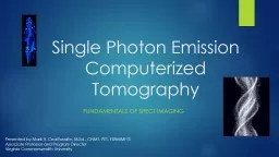
Single Photon Emission Computerized
by caitlin
Tomography. Fundamentals of SPECT Imaging. Present...
Determining the extent and dynamics of
by jordyn
surface water for the ABoVE field campaignML Carro...
Land account
by jacey
sand Ecosystem ExtentDRAFTAuthors Emil Ivanov and ...
UNITED NATIONS Working Paper No 13A GROUP OF EXPERTS ON GEOGRAPHIC
by julia
1 Item 9 of the Provisional Agenda MEETING...
Use of Solar Induced Fluorescence and LIDAR to Assess Vegetation
by barbara
Change and VulnerabilityMarch 16 25 2021Part 2 Que...
Associate Professor
by carla
YI DU , Ph.D. Email: duyi@sspu.edu.cn Tel: Resear...
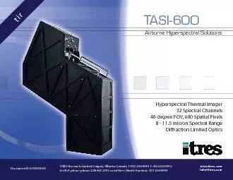
ITRES Research Limited Calgary Alberta Canada T4032509944 F 40
by della
Document ID: U10038-05 TASI-600 Airborne Hyperspec...
Probabilistic Data Management
by camstarmy
Chapter 7: Probabilistic Query Answering (5). 2. O...
Spatial data management iSIKHNAS
by missroach
Background. Spatial data. Locations, names, bounda...
A simple statistical method for estimating the
by araquant
effect of systematic errors in climate data sets o...
Accuracies, Errors, and Uncertainties of Global Cropland Products
by cheryl-pisano
Accuracies, Errors, and Uncertainties of Global C...
Tweet Emotion Mapping: Understanding US Emotions in Time and Space
by lois-ondreau
Tweet Emotion Mapping: Understanding US Emotions ...
EPID 799C Fall 2018 Maps 1
by min-jolicoeur
https://geocompr.robinlovelace.net/adv-map.html. ...
20 July 2016 1 Image classification
by danika-pritchard
From ESA Advanced Training course on Land Remote ...
A collaboration between Ford University Research Program and University of Minnesota
by conchita-marotz
Designing On-Demand Spatial Service Brokers. Reem...
Geospatial Research Methods
by natalia-silvester
Instructor: Jim Graham. E-mail: James.Graham@Humb...
Washington DC, March 18 th
by natalia-silvester
, 2016. Land management systems as the backbone o...
Geographic Information
by pasty-toler
Systems. ASM 215. Feb 2013. Larry Theller. Schedu...
Spatial and Spatio-temporal
by min-jolicoeur
Data Uncertainty: . Modeling and Querying. Mohame...
Interpolation - applications
by marina-yarberry
Interpolating a temperature surface. 1. Problem. ...
Module - V Integration of
by liane-varnes
GIS and Remote Sensing. Analysis and Presentatio...
Understanding Vector and Raster
by liane-varnes
DataTitle. Larry C. . Shubat. Professor. The Univ...
Mapping Spatial Distribution of Mangrove Species Using High Resolution Multispectral Data
by marina-yarberry
(Presented at SCGIS Conference, Monterey, US, 201...
GIS in Water Resources Midterm Review 2018
by cheryl-pisano
Blooms Taxonomy of Educational Objectives. 2. Com...
Lecture 18 Varimax Factors
by yoshiko-marsland
and. Empircal. Orthogonal Functions. Syllabus. L...
1 Research Focus Objectives:
by kittie-lecroy
The Data Analysis and Intelligent Systems . (DAI...
Introduction to Spectral Domain
by marina-yarberry
Prepared by: Amanda Muyskens. Outline. Background...
November 29, 2012 Karyn Backus
by tawny-fly
Epidemiologist. CT Department of Public . Health....
Case Study: Effect of
by tawny-fly
resolution . enhancement . on . the . accuracy ....
G eospatial predictive modeling of the
by calandra-battersby
V-2 Ballistic Missile. Andrew Stangl, MGIS Candid...
The Common Raven in Eastern U.S. Urban Environments, 1950-2010
by olivia-moreira
An Epidemiological Method For An Ecological Quest...
A network scan of horizontal road geometry
by olivia-moreira
Desmond O’Connor. spatial data analyst. What is...
Integrating Official Statistics and Geospatial Information
by danika-pritchard
– ABS experience . Frank Yu. First Assistant St...
Acknowledgments Jennifer Fowler, University of Montana, Flight Director UM-BOREALIS
by ellena-manuel
Roger DesJardins, Canadian East Fire Region, Inci...
Load More...