/
Unlocking New Horizons With Aerial Solutions For Industries Unlocking New Horizons With Aerial Solutions For Industries

Unlocking New Horizons With Aerial Solutions For Industries - PDF document

Eyebot
Eyebot . @Eyebot
Follow
66 views
Uploaded On 2023-12-02

Unlocking New Horizons With Aerial Solutions For Industries - PPT Presentation

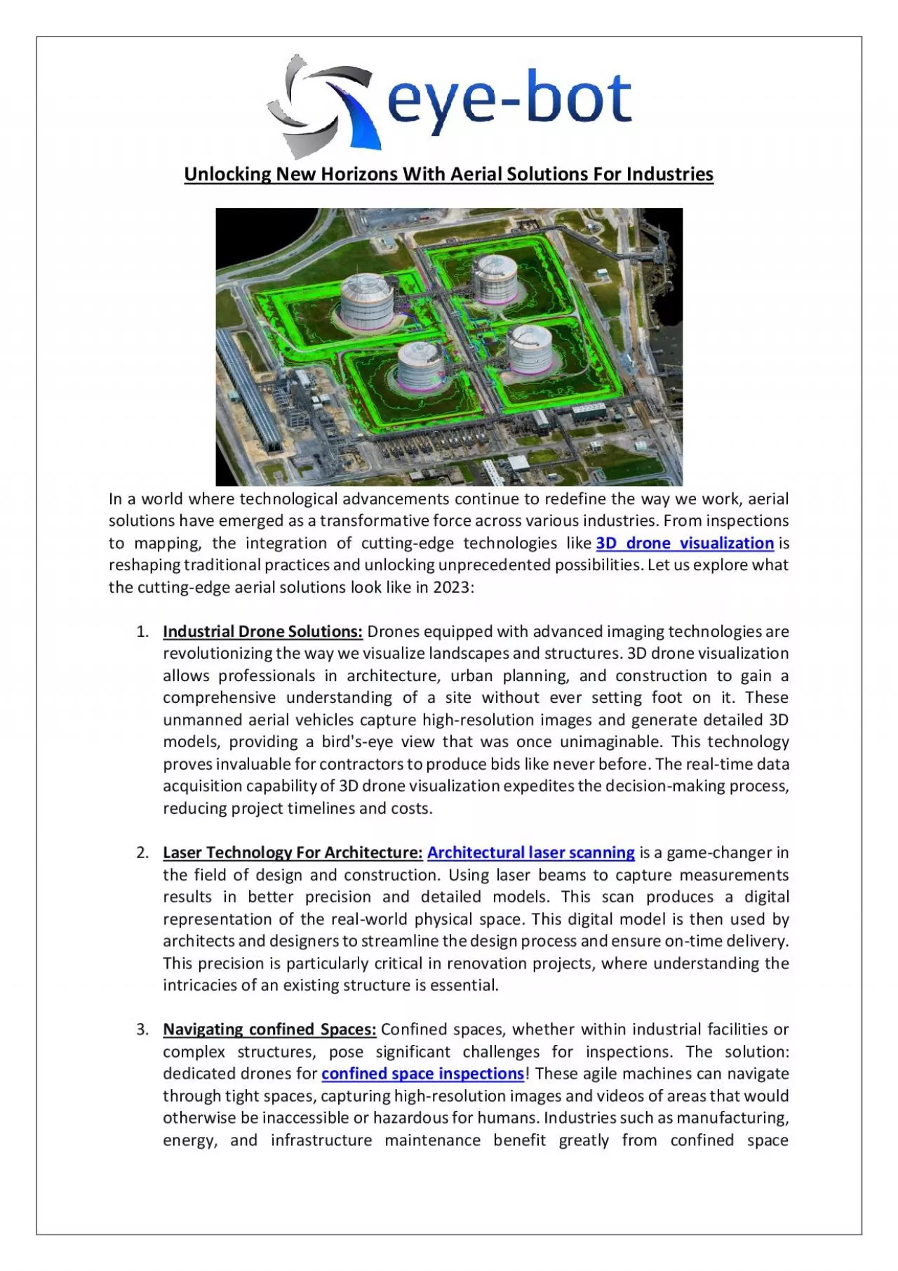
Aerial solutions are reshaping industries and pushing the boundaries of what was once thought possible Here explore what the cuttingedge aerial solutions look like in 2023 ID: 1035115

Aerial solutions

Share:

Link:

Embed:

Download Presentation from below link

Download Pdf The PPT/PDF document "Unlocking New Horizons With Aerial Solut..." is the property of its rightful owner. Permission is granted to download and print the materials on this web site for personal, non-commercial use only, and to display it on your personal computer provided you do not modify the materials and that you retain all copyright notices contained in the materials. By downloading content from our website, you accept the terms of this agreement.


Presentation Transcript

Unlocking New Horizons With Aerial Solutions For I ndustries In a world where technological advancements continue to redefine the way we work, aerial solutions have emerged as a transformative force across various industries. From inspections to mapping, the integration of cutting - edge technologies like 3D drone visualization is reshaping traditional practices and unlocking unprecedented possibilities. Let us explore what the cutting - edge ae rial solutions look like in 2023: 1. Industrial Drone Solutions: Drones equipped with advanced imaging technologies are revolutionizing the way we visualize landscapes and structures. 3D drone visualization allows professionals in archit ecture, urban planning, and construction to gain a comprehensive understanding of a site without ever setting foot on it. These unmanned aerial vehicles capture high - resolution images and generate detailed 3D models, providing a bird's - eye view that was on ce unimaginable. This technology proves invaluable for contractors to produce bids like never before. The real - time data acquisition capability of 3D drone visualization expedites the decision - making process, reducing project timelines and costs. 2. Laser Te chnology For Architecture: Architectural laser scanning is a game - changer in the field of design and construction. Using laser beams to capture measurements results in better precision and d etailed models. This scan produces a digital representation of the real - world physical space. This digital model is then used by architects and designers to streamline the design process and ensure on - time delivery. This precision is particularly critical in renovation projects, where understanding the intricacies of an existing structure is essential. 3. Navigating confined Spaces: Confined spaces, whether within industrial facilities or complex structures, pose significant challenges for inspections. The s olution: dedicated drones for confined space inspections ! These agile machines can navigate through tight spaces, capturing high - resolution images and videos of areas that would otherwise be inaccessible or hazardous for humans. Industries such as manufacturing, energy, and infrastructure maintenance benefit greatly from confined space inspections using drones. By reducing the need for human entry into potentially dangerous environments, t hese aerial solutions enhance safety standards while simultaneously improving the efficiency of inspections. 4. Drone Mapping For Industries: Drone mapping and modeling have transformed traditional surveying and mapping processes. Compared to traditional human surveyors, drones quickly survey large areas with better details and accuracy. The time and cost savings achieved by using drones benefit industries by generating higher revenue and increasing profit margins. 5. Laser Scanning Services: The demand for precision in 3D modeling and scanning has given rise to specialized services offering expertise. 3D laser scanning services leverage state - of - the - art equipment and skilled professionals to provide accurate and detailed scans of structures and landscapes. Businesses can outsource these services to ensure the highest level of precision without the need for substantial in - house i nvestments. It is a cost - effective solution that allows organizations to tap into the benefits of advanced aerial technologies without the burden of maintaining specialized equipment and training personnel. In conclusion Aerial solutions are reshaping ind ustries and pushing the boundaries of what was once thought possible. As these technologies evolve, the potential for innovation and efficiency across various sectors becomes limitless. Browse the best service providers in North America and contact them fo r professional assistance.