/
 1151731  1151731

1151731 - PowerPoint Presentation

alexa-scheidler
alexa-scheidler . @alexa-scheidler
Follow
365 views
Uploaded On 2018-02-02

1151731 - PPT Presentation

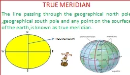
TRUE MERIDIAN The line passing through the geographical north pole geographical south pole and any point on the sourface of the earthis known as true meridian N W E S TRUE MERIDIAN ID: 627350

line bearing meridian magnetic bearing line magnetic meridian true pole direction 180 declination angle survey measured called 2nd error

Share:

Link:

Embed:

Download Presentation from below link

Download Presentation The PPT/PDF document " 1151731" is the property of its rightful owner. Permission is granted to download and print the materials on this web site for personal, non-commercial use only, and to display it on your personal computer provided you do not modify the materials and that you retain all copyright notices contained in the materials. By downloading content from our website, you accept the terms of this agreement.


Presentation Transcript

Slide1

TRUE MERIDIANThe line passing through the geographical north pole ,geographical south pole and any point on the sourface of the earth,is known as true meridian.

N

W

E

S

TRUE MERIDIANSlide2

MAGNETIC MERIDIAN When a magnetic needle is suspended freely and balanced properly,unaffected by any magnetic substances,its indicates a direction.This direction is known as magnetic meridian.Slide3

ARBITRARY MERIDIAN Sometimes for the survey of a small area, a convenient direction is assumed as a meridian ,is known as arbitrary meridianSlide4

GRID MERIDIAN Sometimes for preparing a map some state agencies assume several lines parallel to the true meridian for particular zone, these lines are known as grid lines , and the central line is called grid meridian.Slide5

WHOLE CIRCLE BEARING The magnetic bearing of the line measured clockwise from the north pole towards the line ,is known as whole circle bearing .Slide6

QUADRANTAL BEARINGThe magnetic bearing of the line measured clockwise OR anticlockwise from the north pole or south pole towards the east or west,is known as quadrantel bearing.Slide7

REDUCED BEARINGThe magnetic bearing of the line measured clockwise from the north pole or south pole towards the east or west,is known as REDUCED bearingSlide8

FORE BEARING The bearing of the line measured in the direction of the progress of survey,is called fore bearing(FB)

A

B

FB

BBSlide9

BACK BEARING The bearing of the line measured in the OPPOSITE direction of the progress of survey,is called back bearing(BB)

A

B

FB

BBSlide10

MAGNETIC DECLINATION The angle between magnetic meridian and true meridian is known as a magnetic declinationSlide11

AGONIC LINE The line passsing through points of zero declination is said to be agonic line ISOGONIC LINE The line passing through points of equal declination is said to be isogonic line

0

5W

5E

3W

3ESlide12

LOCAL ATTRACTION When a magnetic needle suspend freely without any influence of magnetic substances, its indicate the direction correctly, but when it influence by any magnetic substances,the direction is not correct,this influence is called local attractionSlide13

PRINCIPLE OF COMPASS SURVEY 1.A large area to be surveyed 2.The course of river or coast line is to be surveyed 3.The area is crowded with many details or triangulations is not possible.Slide14
Slide15
Slide16

BB = FB ± 180 FB = BB ± 180 If BB or FB is less then 180. Than +180. if BB or FB is greater then 180. Than -180 is required.Slide17

Magnetic bearing =True bearing ± Declination

True bearing =Magnetic bearing ± Declination Slide18

CLOCKWISE BB of 1st – FB of 2nd = interior angle FB of 2nd –BB of 1st =exterior angle

ANTICLOCKWISE FB of 2nd –BB of 1st =INTERIOR angle BB of 1

st – FB of 2nd = EXTERIORangleSlide19

INTERIOR ANGLE =(2N-4)×90/N TOTAL ANGLE =(2N-4)×90 N=NUMBER OF SIDESSlide20

WHENFB-BB=180THE line is free from local attractionSlide21

Equipmen for compass survey 1.pencil 2.eraser 3.sharpner 4.field book 5.arrows 6.ranging rods 7.pegs 8.metric chain 9.prismatic compass

10.tri-square 11.optical square 12.mallet 13.knife 14.plumb boobSlide22

When a close traverse is plotted. The starting and finishing points may not be coincide. The distance by whice the traverse fails to close is said to the error .such an error may occur due to mistakes made in measurement of lengths and bearings of the lines or because of an error in plotting.if the closing error exceeds a certain permissible limit ,the field work should be repeated,but when it is within permissible level.it is adjusted geographically.

Related Contents


Next Show more