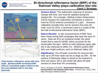
PPT-Examining Surface Reflectance, NDVI and LAI from TM, ETM and OLI for Data Fusion and
Author : alexa-scheidler | Published Date : 2018-10-25
Feng Gao Martha Anderson Liang Sun Yang Yang Yun Yang and also contributed by David Roy and his group Landsat Science Team Meeting Virginia Tech January 1214
Presentation Embed Code
Download Presentation
Download Presentation The PPT/PDF document "Examining Surface Reflectance, NDVI and ..." is the property of its rightful owner. Permission is granted to download and print the materials on this website for personal, non-commercial use only, and to display it on your personal computer provided you do not modify the materials and that you retain all copyright notices contained in the materials. By downloading content from our website, you accept the terms of this agreement.
Examining Surface Reflectance, NDVI and LAI from TM, ETM and OLI for Data Fusion and: Transcript
Feng Gao Martha Anderson Liang Sun Yang Yang Yun Yang and also contributed by David Roy and his group Landsat Science Team Meeting Virginia Tech January 1214 2016 USDA is an equal opportunity provider and employer. source sensor surface element normal brPage 3br BRDF Bidirectional Reflectance Distribution Function T I source viewing direction surface element normal incident direction I T I T surface I T surface I T Irradiance at Surface in direction I T Radian Louisiana Moon Glint—Preliminary Review. 12 January 2014. Steve Miller. CSU/CIRA. Moon Glint Angle. Ocean Surface. θ. < ~30˚. θ. . G. lint Angle. θ. < ~10˚. When the Moon-Satellite geometry is favorable, there is the possibility for brightening of the water surface from lunar reflectance, just as in the day.. Dan . Sauceda. Outline. Information on the Region. Data Information. Reflectance Equations. MODIS Images. NDVI. Conclusions. Information on the Region. Latitude: 0. ˚N, -12˚S. Longitude: -56˚. E, -72. Principles & Practice of Remote . Sensing. EM . Radiation (. ii). Dr. Mathias (Mat) Disney. UCL Geography. Office: 113, Pearson Building. Tel: 7679 0592. Email: mdisney@ucl.geog.ac.uk. http://www2.geog.ucl.ac.uk/~mdisney/teaching/GEOGG141/GEOGG141.html. 2. . NOAA/STAR; 3. UMBC JCET; 4. UMD ESSIC; 5. SRG. Introduction. Surface reflectance ratios are crucial to the VIIRS (Visible Infrared Imaging Radiometer Suite) aerosol optical thickness (AOT) retrieval over land for dark pixels. Having better estimates of these ratios can improve AOT retrievals. . Chengquan. Huang. 1,2. . Min Feng. 1,2. , . Joseph O. . Sexton. 1,2. , . Raghuram. . Narasimhan. 1,2. , . Saurabh. . Channan. 1,2. , Jeff . Masek. 3. , Eric . Vermote. 2. , . Feng. Gao. 4. , John Townshend. Cody . Anderson*, . Dennis . Helder. *, and Jeff Czapla-Myers**. *USGS EROS, **University of Arizona. Level 2 Surface Reflectance Product Validation Thoughts. Surface Reflectance Validation Thoughts (1). 2. . NOAA/STAR; 3. UMBC JCET; 4. UMD ESSIC; 5. SRG. Introduction. Surface reflectance ratios are crucial to the VIIRS (Visible Infrared Imaging Radiometer Suite) aerosol optical thickness (AOT) retrieval over land for dark pixels. Having better estimates of these ratios can improve AOT retrievals. . Jim . Schepers. (emeriti). Agronomy and Horticulture Dept.. University of Nebraska. Premise. . – in-season differences in . crop vigor . will be proportional to . yield. at harvest . . “ No correlation between looks . 15-463, 15-663, 15-862. Computational Photography. Fall 2018, Lecture 16. http://graphics.cs.cmu.edu/courses/15-463. Homework 4 is still ongoing. - Any questions?. I will try to go over project ideas tonight.. (from: METRIC: Mapping Evapotranspiration at high Resolution using Internalized Calibration). University of Idaho, Kimberly, Idaho. University of Nebraska-Lincoln. Landsat – Polar Orbiting. A new image each 16 days. Carol J. Bruegge. Science driver: . The radiometric response of sensors change with time, and must be updated during the mission life. For example, Orbiting Carbon Observatory (OCO) requires 5% radiometric uncertainty in order to meet its XCO2 retrieval uncertainty of 1 ppm. Vicarious calibration provides this, but for sensors that view off-nadir, such as OCO, a necessary input is a model of the test site bi-directional reflectance factor (BRF).. University of . Arizona. NASA MEASURES #. NNX08AT05A . Science Review Panel . Meeting. Biosphere 2, Tucson, . AZ - January 4-5, 2011 . Vegetation Phenology and Vegetation Index Products from Multiple Long Term Satellite Data Records. Surface albedo. NDVI. Remotely sensed . information on surface . albedo . and . NDVI. . is used . in climate modeling and research. .. Above parameters . and surface . temperature. and . radiative.
Download Document
Here is the link to download the presentation.
"Examining Surface Reflectance, NDVI and LAI from TM, ETM and OLI for Data Fusion and"The content belongs to its owner. You may download and print it for personal use, without modification, and keep all copyright notices. By downloading, you agree to these terms.
Related Documents