PPT-Figurer le territoire au niveau local : tension entre carte
Author : alida-meadow | Published Date : 2017-07-26
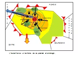
La diffusion de la carte quelques indices The diffusion of the Map some clues Moyenne annuelle des productions de cartes et plans moyenne par décennie 16001900
Presentation Embed Code
Download Presentation
Download Presentation The PPT/PDF document "Figurer le territoire au niveau local : ..." is the property of its rightful owner. Permission is granted to download and print the materials on this website for personal, non-commercial use only, and to display it on your personal computer provided you do not modify the materials and that you retain all copyright notices contained in the materials. By downloading content from our website, you accept the terms of this agreement.
Figurer le territoire au niveau local : tension entre carte: Transcript
Download Rules Of Document
"Figurer le territoire au niveau local : tension entre carte"The content belongs to its owner. You may download and print it for personal use, without modification, and keep all copyright notices. By downloading, you agree to these terms.
Related Documents