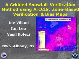
/
DAY 3 Winners  Redux  =  SPC DAY 4 - Forecast Verification time! DAY 3 Winners  Redux  =  SPC DAY 4 - Forecast Verification time!

DAY 3 Winners Redux = SPC DAY 4 - Forecast Verification time! - PowerPoint Presentation

calandra-battersby
calandra-battersby . @calandra-battersby
Follow
342 views
Uploaded On 2019-11-05

DAY 3 Winners Redux = SPC DAY 4 - Forecast Verification time! - PPT Presentation

DAY 3 Winners Redux SPC DAY 4 Forecast Verification time Perfect Forecast The Dr Titley residence one block from campus 82 Y 9 82 Y 9 35 35 DAY 4 Winners Lets talk about those temps ID: 763455

forecast map sfc model map forecast model sfc sat 18z nam valid tropical radar guidelines spc evening weather climatology

Share:

Link:

Embed:

Download Presentation from below link

Download Presentation The PPT/PDF document "DAY 3 Winners Redux = SPC DAY 4 - For..." is the property of its rightful owner. Permission is granted to download and print the materials on this web site for personal, non-commercial use only, and to display it on your personal computer provided you do not modify the materials and that you retain all copyright notices contained in the materials. By downloading content from our website, you accept the terms of this agreement.


Presentation Transcript

DAY 3 Winners Redux = SPC

DAY 4 - Forecast Verification time! ? Perfect Forecast

The Dr. Titley residence (one block from campus) 82 Y 9

82 Y 9 3.5 3.5

DAY 4 Winners

Let’s talk about those temps …. This week … Monday: 77 Tuesday: 79 Wednesday: 71 Thursday: 82 TEMPS Avg./mean: 81 CLIMATOLOGY Median: Range: 82 90 - 68Std. dev .7

Let’s talk about the clouds = Sat imagery Conduction Convection Buoyancy Daytime heating = Cloud maker Large-scale subsidence = Cloud killer 500 mb analysis = Thurs. evening

RH Calculator Relative Humidity – How close the air is to saturation - Varies between? (X and Y %) - If in a cloud ….. RH = ? Dew Point – Absolute humidity (how much H20 v) T = 85 D = 65 RH = 51% What do we need to do to T and/or D to produce a cloud ?

500 mb analysis = Thurs. evening

Tornado Climatology – Whisker plots

Air Mass Large volume of air with certain Temp and Moisture Characteristics Continental Tropical, Maritime Tropical, Continental Polar, Maritime Polar

Maritime Tropical Continental Tropical Maritime Polar Continental Polar

Summer - DayT = 105 TD = 38T = 67 TD = 58 T = 77 TD = 45T = 93 TD = 76 Winter- Day T = 15 TD = -5 T = 72 TD = 65T = 72 TD = 20 T = 38 TD = 33 Maritime Tropical Continental Tropical Maritime Polar Continental Polar

Let’s talk about the rain …. Our forecast period

CLIMATOLOGY

THIS EVENING – 500MB SPC

Z = EDT 12z=8 am 18z=2 pm 00z=8pm 06z=? 500 mb map- GFS model. Valid 8 p.m. TUESDAY

H SPC TUE EVENING – SURFACE MAP

H WED EVENING – SURFACE MAP SPC

Tuesday Wednesday mid 70s – mid 80s Upp 6 0s – upp 70s SPC

THIS EVENING – 500MB

H L THIS EVENING – SFC map

Penn State Weather CampsBasic Weather Forecasting Guidelines Sat I – Sat II – Sat III - NWS – SPC - NHC – Radar - Radar - Radar E-WALL - sfc. map 1 - sfc. map 2 - ltg

DEW POINT TEMP TODAY ( 2PM – 8 PM EDT) SPC

THIS EVENING – 700MB RH

ACCUM PRECIP – 18Z TO 00Z (2 PM – 8 PM)

Joe Schmo 90 Y 3.50” PA

WHAT IS CLIMATOLOGY ? How the weather behaves over a long period of time. Weather – Behavior of the atmospheric over a much shorter period of time

TEMPSAvg./mean: 81 RAIN Avg./Mean: Range: % time: 0.15” 0-1.79” 43% CLIMATOLOGYMedian:Range: 82 90 - 68 Std. dev . 7 30 year period - common NORMAL? Conforming to a regular pattern; typical 60’s = 70’s = 80’s = 90’s = 2 8 18 2

WHAT IS PERSISTENCE ?ASSUMES NO CHANGE ! WHAT HAPPENED … WILL CONTINUE TO HAPPEN

Climatology Forecast Persistence Forecast Key West Chicago CLI 88 80 6/17 88 93 6/18 86 95 6/19 89 81 6/20 90 77 6/21 87 67 6/22 89 646/23 90 81AVG ERR. 1.3 9 Key West Chicago 6/17 88 936/18 -2 +26/19 +3 -146/20 +1 -46/21 -3 -106/22 +2 -36/23 +1 +17 AVG ERR. 2 9

PSU SNOWFALL

Penn State Weather CampsBasic Weather Forecasting Guidelines Sat I – Sat II – Sat III - NWS – SPC - NHC – Radar - Radar - Radar E-WALL - sfc. map 1 - sfc. map 2 - ltg

Traditional 4-Panel Model Output 500 mb 700 mb SLP map + THK Accumulate Precip

Upper Level Map (i.e. 500mb) Balance between 2 forces …. Pressure Gradient + ??

SURFACE PRESSURE (SLP) ? ? ?

Geostationary Satellite 22,000 miles above equator

De donde son ustedes ?

L H JET STREAM This Afternoon 500 mb (~18,000 feet)

H H JET STREAM – LATER THIS WEEK L

Basic Forecast Guidelines - TEMP Cause of temperature to change : S unshine?Wind direction?

WX CAMP - ForecastingLocation – STATE COLLEGE TEMP – PRECIP – SKY COVER 90F YES ?

Joe Smith 81 8 Yes

Basic Forecast Guidelines What causes rain ? Need clouds !Will any ole cloud do?MoistureBodies of water – Moisture content of air

NORMAL Conforming to a standard; usual, typical, or expected.

Basic Forecast Guidelines What causes temperature to change ? How much sunshine? How much precipitation?Wind direction?

Basic Forecast Guidelines Extrapolation = Look upstream to see what’s coming!Sat IR - Sat II - Sat VIS - Radar - sfc. map 1 - sfc. map 2 – sfc map 3

Basic Forecast Guidelines The “Models” What are they? The “Models” Lower Res. (GFS) Higher Res. (GFS ) Higher Res. (NAM) Higher Res. (HRRR)MOS - Statistical guidance

TROF AVIS TROF AVIS PA

Cyclogenesis

E-WALL - clouds MOS - clouds RH at 700 mb 18z WED

SFC Temperature Forecasting Techniques Climatology Persistence Modified Persistence Models 2 meter temp output MOS (statistical)

Basic Forecast Guidelines Climatology Forecast = averages for today Persistence Forecast = yesterday’s values Modified Persistence = Persistence + Any changes

Nighttime infrared satellite imagery suggests that the circulation associated with the low pressure area in the Gulf of Mexico is gradually becoming better defined. However, the system is struggling to maintain organized convection near the center, andthe radius of maximum winds remains large. Based on this, the system is still maintained as a potential tropical cyclone.

The low is moving erratically northwestward around the southwestern portion of a deep-layer ridge located over the western Atlantic and Florida . The large-scale models suggest this ridge will strengthen some during the next 36 hours or so and cause the low to turn a little more westward. This would be followed by a northward turn around the western end of the ridge and eventual recurvature into the westerlies . Overall, there has been a left shift of the track guidance models since the previous advisory. The new forecast track is also shifted left, but it is to the right of the modelconsensus, especially at 36-48 h. Given the nature of the circulation, though, and the fact that the wind and rain hazards extend well north and east of the center, users are encouraged to not focus on the details of the track forecast.

The initial intensity remains 35 kt based on partial scatterometer overpasses and continuity from the previous advisory. Significant strengthening is unlikely due to strong vertical shear caused by an upper-level trough over the northwestern Gulf of Mexico and entrainment of dry air into the system. However, the large-scale models suggest slight strengthening before landfall, and thus the intensity forecast is unchanged from the previous advisory. One change from the previous advisory is that it now appears more likely that the system would become a subtropical cyclone rather t han a tropical cyclone due to the current structure of the low and interaction with the aforementioned trough. That being said, development into a tropical cyclone remains possible. The primary hazard from this disturbance is expected to be heavy rainfall over portions of the central and eastern Gulf Coast.

FORECAST POSITIONS AND MAX WINDSINIT 20/0900Z 24.8N 90.1W 35 KT 40 MPH...POTENTIAL TROP CYCLONE 12H 20/1800Z 25.7N 91.0W 35 KT 40 MPH...SUBTROPICAL CYCLONE 24H 21/0600Z 26.6N 92.1W 40 KT 45 MPH 36H 21/1800Z 27.5N 93.0W 40 KT 45 MPH 48H 22/0600Z 28.9N 93.5W 40 KT 45 MPH 72H 23/0600Z 32.5N 93.5W 25 KT 30 MPH...INLAND 96H 24/0600Z 36.5N 88.0W 20 KT 25 MPH...POST-TROP/INLAND

Our friends …. Storms Prediction Center

NAM MODEL – 4 panel map Valid at 8 a.m. (12z) YESTERDAY

NAM MODEL – 500 mb . map Valid 8 a.m. (12z) YESTERDAY H L H Ridge Trough

NAM MODEL – SFC map Valid 8 a.m. (12z) YESTERDAY

NAM MODEL – SFC map Valid 8 P.M. (00z) YESTERDAY

LIFTED INDEX Valid 2 P.M. (18z) YESTERDAY

5 a.m. (09z)

NAM MODEL – 4 panel map Valid at 2 p .m. (18z)

NAM MODEL – sfc map Valid at 2 p.m. (18z)

NAM MODEL – 500 mb Valid at 2 p .m. (18z) L Trough axis

LIFTED INDEX Valid 2 P.M. (18z) TODAY

Penn State Weather CampsBasic Weather Forecasting Guidelines Sat I – Sat II – Sat III – Sat WV - NWS - NHC – Radar - Radar sfc. map 1 - sfc. map 2 – sfc map 3

NAM MODEL – Precip. mapTotals (2 pm – 8 pm) (18z – 00z) GFS MODEL – Precip . map Totals (2 pm – 8 pm) (18z – 00z)

NAM MODEL – Precip. mapTotals (2 pm – 8 pm) (18z – 00z) GFS MODEL – Precip . map Totals (2 pm – 8 pm) (18z – 00z)

SURFACE PRESSURE ? ? ? ? ?

SURFACE PRESSURE

Warm Sector vs. Cool Sector

MOS – Model Output S …Accu Friends Wx Channel Friends NWS Friends

Know what to expect! = Climo. RH RL NH NL

Big Picture …. Then details  Soundings ? Model soundings Other fun output Meteograms

Big Picture …. Then details  Temps + Clouds Soundings – What are these? Model soundings Other fun outputMeteograms