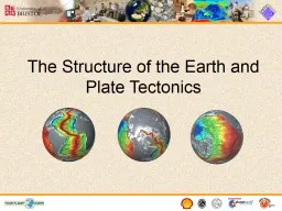
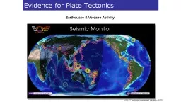
/
RIEF OVERVIEW OF PLATE TECTONICS Since ancient times, the name Terra F RIEF OVERVIEW OF PLATE TECTONICS Since ancient times, the name Terra F

RIEF OVERVIEW OF PLATE TECTONICS Since ancient times, the name Terra F - PDF document

calandra-battersby
calandra-battersby . @calandra-battersby
Follow
387 views
Uploaded On 2016-04-30

RIEF OVERVIEW OF PLATE TECTONICS Since ancient times, the name Terra F - PPT Presentation

This theory has unified the study of the Earth and proven to be as relevant to the earth sciences as was the discovery of the structure of the atom to physics and chemistry and as was the theory o ID: 300422

This theory has unified

Share:

Link:

Embed:

Download Presentation from below link

Download Pdf The PPT/PDF document "RIEF OVERVIEW OF PLATE TECTONICS Since a..." is the property of its rightful owner. Permission is granted to download and print the materials on this web site for personal, non-commercial use only, and to display it on your personal computer provided you do not modify the materials and that you retain all copyright notices contained in the materials. By downloading content from our website, you accept the terms of this agreement.


Presentation Transcript

RIEF OVERVIEW OF PLATE TECTONICS Since ancient times, the name Terra Firma (meaning "solid ground" in Latin) sometimes has been and ). This theory has unified the study of the Earth and proven to be as relevant to the earth sciences as was the discovery of the structure of the atom to physics and chemistry, and as was the theory of evolution to the life sciences. Even is booklet partially filled the need, but additional classroom . This activity is based on Alfred Wegener's pioneering studies that demonstrated that the scattered distribution of certain fossil plants and animals on presentÐday, widely separated continents would form the World acquire, process, and report information. ¥ STANDARD 3: How to analyze the spatial organization of people, places, and environments on grade 6 Ð Appendix 3 (can made into an overhead). This Dynamic Planet Booklet (http://pubs.usgs.gov/gip/dynamic/). FOR EACH STUDENT GROUP: Student Map of the World HIS DYNAMIC EARTH AND THIS DYNAMIC Have the students look for all the pieces with the fossil remains of Cynognathus and then put them together (South America and Africa). 2. Then look for fossils that extend beyond the plate boundary such as the fern Glossopteris and the land-dwelling reptile Lystrosaurus. Put all of the continents with Glossopteris and Lystrosaurus near each other. Notice how two of the continents (Africa and Antartica) have the end regions of Lystrosaurus. Lystrosaurus is the key to solving the puzzle. What happens to the other continent (India) if you put Antartica next to Africa? The students must place India next to Africa to complete the puzzle. groups debate their positions. For an interesting twist, put students into groups opposite to their view. Ask students to think about continental reconstructions older than 250 million years ago. What would be the difficulties in creating a paleogeographic reconstruction of the continents 1 billion years ago? ADDITIONAL RESOURCES A good animation of plate movement over time can be found at (Appendix 11). If you do not have a copy of the This Dynamic Planet Map (download at http://pubs.usgs.gov/imap/2800/) (Interactive version available - http://volcano.si.edu/tdpmap/), you will want to download parts of it, in particular, the interpretive map (Appendix 12). OBJECTIVES ¥ Students will examine one method for creating a two-dimensional map of a spherical surface. ¥ Students will create a model of the earth that they can hold and examine. ¥ Students will examine plate boundaries, continents, and oceans on a globe. ¥ Students will examine divergent, convergent, and transform plate boundaries. ¥ Students will draw plate boundaries on a map and learn that more scientific data are needed to more accurately locate certain boundaries. ¥ Students will compare the features on a map that fits on a sphere with the same features on a more standard flat, two-dimensional, map to learn how our standard maps are distorted towards the poles. EFERENCE TO DYNAMIC EARTH BOOKLET AND DYNAMIC PLANET MAP Dynamic Planet map (available as a pdf). ¥ New tennis balls will work, but since they are very fuzzy, they will be more difficult to glue onto. Tennis ball sizes vary slightly and the model may not fit exactly. ¥ Tennis balls are usually available if you have a tennis club or courts nearby and you let people there that you need them for a science project. A bag or box should be supplied to collect them. ¥ We recommend using six or more colors for coloring the map. The map can be colored with only four different colors but it's a classic logic puzzle and math problem (four color theorem) - see extensions below. INSTRUCTIONS FOR ACTIVITY (TEACHER INSTRUCTIONS INCLUDES ANSWERS TO TRENCH OCEANIC SPREADING RIDGE CONTINENTALLITHOSPHERE ASTHENOSPHERE(semi-solid, slowlyflowing upper mantle) OCEANIC LITHOSPHERE LOWER MANTLE Magmasource Magmasource 11 14 13 12 1 2 3 4 5 6 7 8 9 10 100 km 100 km VERTICAL SCALEHIGHLY EXAGGERATED ASTHENOSPHERE ASTHENOSPHERE Â¥ Students will interpret the evidence to formulate a hypothesis. Â¥ Students will defend their position on continental drift. To start this activity the teacher will present background information on Wegener. Students will then be placed into groups of 2 to 3 and work to piece together continent cut-outs using this evidence. As students fit the continents together they find that isolated pieces of geologic information are no longer isolated. Groups describe what they have found, and must defend their conclusion by explaining how the evidence supports or refutes continental drift. [Materials available online at http://volcanoes.usgs.gov/about/edu/dynamicplanet ] Tim ndards: Â¥ STANDARD 1: How to use maps and other geographic representations, tools, and technologies to acquire, process, and report information. Â¥ STANDARD 3: How to analyze the spatial organization of people, History of science researchers, climate/culture of scientific community at the time of the research Language Arts - Writing persuasive essays, pres out sheet containing fossil evidence (Student Puzzle Pieces), the Key to Wegener's Evidence sheet, the Student Map of the World Today reference sheet, crayons or markers, and a pair of scissors. Â¥ Groups label the Have the students arrange the puzzle pieces using the Key to Wegener's Evidence to support their arrangement. Â¥ The final puzzle configuration should be attached to paper with glue or tape. Â¥ When finished, each group will present and defend their reconstruction. Â¥ You may compare the students' reconstructions with Wegener's Key to Continental Positions about 250 million years ago (Teacher Copy) Hints for solving the puzzle Â¥ Have the students look for all the pieces with the fossil remains of Cynognathus and then put them together (South America and Africa). Â¥ Then look for fossils that extend beyond the plate boundary such as the fern Glossopteris and the land-dwelling reptile Lystrosaurus. Put all of the continents with Glossopteris and Lystrosaurus near each other. Notice how two of the continents (Africa and Antartica) have the end regions of Lystrosaurus. Lystrosaurus is the key to solving the puzzle. What happens to the other continent (India) if you put Antartica next to Africa? The students must place India next to Africa to complete the puzzle. Â¥ You can also use the Puzzle Outline Hint as a base for the puzzles. Teacher See also illustrations on pages 1 and 8 of This Dynamic Earth. Assessment suggestions Students evaluate WegenerÕs hypothesis based on the evidence they observe. Â¥ Student groups each write a Ôposition paperÕ on whether the evidence they researched is compelling and conclusive enough for scientific acceptance of the Theory of Contine For self assessment, the teacher may hand out the Wegener's Key to Continental Positions. Extensions Assign students to two groups, those who have determined that the evidence supports the theory of continental drift, and those who believe that the evidence does not support the theory. Have these two groups debate their positions onstruction of the continents 1 billion years ago? Additional resources A good animation of plate movement over time can be found at www.scotese.com. U.S. Department of the InteriorU.S. Geological Survey The sixth grade exercise does not include North America, Madagascar, or Eurasia. A high school version will be released in the future that will contain additional continents along with the rock evidence. Key for 6th Grade Exercise DIRECTIONS: Cut out each of the continentalland masses along the edge of the continentalshelf (the outer line). Fossil Evidence U.S. Department of the InteriorU.S. Geological SurveyThis Dynamic Planet; A Teaching Companion GUSS 4.When you are satised with the 't' of the continents, discuss the evidence with your partners and decide if the evidence is Wegener’s Puzzling Evidence Fossils of the fern Glossopteris have been found in these locations . Color the areas with these fossils green.Fossil remains of Cynognathus, a land reptile approximately 3 meters long that lived during the Early Mesozoic Era, about 230 million years ago. It was a weak swimmer. Color the areas with these fossils Fossil remains of the half meter-long fresh or brackish water (reptile) Mesosaurus. Mesosaurs ourished in the early Mesozoic Era, about 240 million years ago. Mesosaurs had limbs for swimming, but could also Fossil evidence of the Early Mesozoic, land-dwelling reptile Lystrosaurus. They reproduced by laying eggs The continents is surrounded by the continental shelf (stippled pattern), which extends beyond the By about 300 million years ago, a unique community of plants had evolved known as the European ora. Fossils of these plants are found in Europe and other areas. Color the areas with these fossils Key to Wegener’s Puzzling Evidence - Fossils continental land masses lie above sea level, but the true edges of the continents are not at the shoreline. The gray areas on this map sea level, but the true edges of the continents are not at the GUSSThis Dynamic Planet; A Teaching CompanionAntarctica This Dynamic Planet; A Teaching CompanionWegener’s Puzzling Continental Drift EvidenceU.S. Department of the Interior The nished puzzle will t within this outline. Some of the pieces may overlap slightly.Hint for 6th Grade Exercise dimensional). S Â¥ Simplified Plate Tectonics Map (not colored) Â¥ Old tenni This Dynamic Planet map Â¥ This Dynamic Earth: p. 2, 6, 7, 15, 16, 29, 30 Ð 38, 43, 50, 52, 56 Additional information for teacher Â¥ The data on the small globe have been simplified for the small size of the project. Â¥ Cutting the map takes dexterity and patience. Â¥ Not all the plate boundaries are easy to see. For some, there is not enough scientific data to determine the precise locations. The students will need to use the insert Interpretive Map on the This Dynamic Planet map (available as a pdf at http://volcanoes.usgs.gov/about/edu/dynamicplanet/ballglobe/interpretive.pdf) Â¥ New tennis balls will work, but since they are very fuzzy, they will be more difficult to glue onto. Tennis ball sizes vary slightly and the model may not fit exactly. Â¥ Tennis balls are usually available if you have a tennis club or courts nearby and you let people there that you need them for a science project. A bag or box should be supplied to collect them. Â¥ We recommend using six or more colors for coloring the map. The map can be colored with only four different colors but itÕs a classic logic puzzle and math problem (four color theorem) Questions from student instr 1. Which plates look the largest to you? There is no ÔrightÕ answer. Many plates may look large but the goal is to have the kids compare the polar regions on both maps. Make sure students notice that most plates contain both continental and oceanic material. 2. Plate boundary types are not always the same across the entire boundary. Suggested answers are given to each question below. The India Ð Australia and North America Ð South America boundaries are not well defined and should not be included in the answers to this set of questions. List three divergent boundaries not including the example. Example: There is a divergent boundary between the Nazca and Pacific plates. Antarctic and Australia, Pacific, South America, Nubia Nubia and South America, India, Antarctic Australia and Antarc List two convergent boundaries. Pacific and North America, Eurasia India and Dynamic Planet map. What boundaries are not as obvious as other boundaries? 4. Color the plates on your Plate Tectonics Tennis Ball Globe following your Simplified Plate Tectonics Map such that no adjacent plates are the same color. Â¥ Which plates look the largest to you? Â¥ How are the plates near the north and south poles different on your Plate Tectonics Tennis Ball Globe map than on your Simplified Plate Tectonics Map? Â¥ What do your observations tell you about maki This Dynamic Planet; A Teaching CompanionPlate Tectonics Tennis Ball Globe&#xhttp;&#x://v;&#xolca;&#xnoes;&#x.usg;&#xs.go;&#xv/ab;&#xout/;íu/; yna;&#xmicp;&#xlane;&#xt000;For updates see U.S. Department of the InteriorU.S. Geological Survey Simplified Plate Tectonics MapPlate boundary - Known area between two plates.Some plate boundaries, such as the North America - South America boundary, are not shown because scientic dataare inadequate to determine precise locations. See the This Dynamic Planet Map insert for more information about these regions. Plate Tectonics Tennis Ball GlobeDivergent (spreading)Fracture zoneConvergent plate boundariesTransform plate boundaries The Earth’s Major Tectonic Plates GUSS Divergent plate boundary - Where new crust is generated as the plates pull away from each other.Convergent plate boundary - Where crust is recycled as one plate dives under another (in the direction shown by sawteeth).Transform plate boundary - Where crust is neither produced nor consumed as plates slide horizontally past each other.