/
Region II: Region II:

Region II: - PowerPoint Presentation

celsa-spraggs
celsa-spraggs . @celsa-spraggs
Follow
406 views
Uploaded On 2016-07-06

Region II: - PPT Presentation

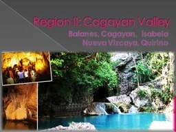
Cagayan Valley Batanes Cagayan Isabela Nueva Vizcaya Quirino Cagayan Valley Lambak ng Cagayan is the vast mass of land in the northeastern region of Luzon It is bounded to the west by the  ID: 393249

cagayan province region vizcaya province cagayan vizcaya region nueva isabela quirino city major area valley batanes mountain land people

Share:

Link:

Embed:

Download Presentation from below link

Download Presentation The PPT/PDF document "Region II:" is the property of its rightful owner. Permission is granted to download and print the materials on this web site for personal, non-commercial use only, and to display it on your personal computer provided you do not modify the materials and that you retain all copyright notices contained in the materials. By downloading content from our website, you accept the terms of this agreement.


Presentation Transcript

Slide1

Region II: Cagayan Valley

Batanes, Cagayan, IsabelaNueva Vizcaya, QuirinoSlide2
Slide3

Cagayan Valley(Lambak

ng Cagayan) is the vast mass of land in the northeastern region of Luzon.It is bounded to the west by the Cordillera Mountain Range, to the east by the Sierra Madre Mountain Range, and bounded by the Babuyan Island, where the waters of the Pacific Ocean in the east and the South China Sea in the west meet. It is composed of five provinces, namely: Batanes, Cagayan

,

Isabela

,

Nueva

Vizcaya

, and

Quirino

.

It has four cities: industrial center 

Cauayan

City

, its regional center

Tuguegarao

, its commercial center 

Santiago City

.

Most of the region lies in a large valley in

northeastern

Luzon

, between the

Cordilleras

and the

Sierra Madre

mountain ranges.

Cagayan River

, the country's longest

river

runs through its

center

and flows out to

Luzon Strait

in the north, in the town of

Aparri

, Cagayan

. The Babuyan and

Batanes

island groups that lie in the Luzon Strait also belong to the region. Slide4

Geography and Economy

Cagayan's area is 9,003 km². Its population was 952,000 (by the 2000 census) in 29 towns, of which Tuguegarao is the capital.the Cagayan Valley has been inhabited for half a million years, though no human remains of any such antiquity have yet appeared. The earliest inhabitants are the Agta, or Atta, food-gatherers who roam the forests without fixed abodes. A large tract of land has lately been returned to them. The bulk of the population are of Malay origin. For centuries before the coming of the Spanish, the inhabitants traded with Indians, Malays, Chinese, and Japanese. In the nineteenth century the prosperity found in tobacco cultivation caused many Ilocanos to settle here. Tobacco is still a major factor in the economy of Cagayan, though a special economic zone and free port has been created to strengthen and diversify the provincial economy.Slide5

Cagayan has much to offer visitors: beaches, swimming, snorkeling, skin-diving, fishing in the river and the sea, hiking in primeval forest, mountain-climbing, archaeological sites, the remarkable collection of the provincial museum, the Callao Caves, and many fine churches. Even here there are fortifications built to protect the inhabitants from raids by the Mara.Slide6

The Philippine Republic's Region II, Cagayan Valley, contains two landlocked provinces, Quirino

and Nueva Vizcaya. Both are relatively small in size (3057 km2 for Quirino, 4081 km2 for Nueva Vizcaya) and population (147,000 and 365,000, respectively, by the 2000 census). They are ruggedly mountainous and heavily forested. Slide7

Let’s go to the 5 provinces of Cagayan Valley: 

Batanes, Cagayan, Isabela, Nueva Vizcaya, and Quirino.Slide8

Welcome to BATANES 

The island-province of Batanes was created by a series of volcanic activities and other geologic forces millions of years ago.The province is home to the famous Ivatans who are nationally acclaimed as the “True Insulares.” Taiwan as well as Spaniards who came to the island in the 16th century. Being an insular people, the Ivatans have kept the purity of their gene pool through time.Slide9

BATANES(Land Of The True Insulars)

Batanes lies at the northernmost tip of the Philippines, where the Pacific Ocean merges with the South China Sea. It is composed of three major/largest islands, namely: Batan which contains the capital town of Basco, Sabtang, and Itbayat. Batanes has been identified as the country’s potential gateway to East China. Its total land area is 209 sq.kmwhich makes it the smallest province in the country. Slide10

Geography

"The island-province is strewn on a 4,500 square kilometer expanse of territorial waters, the Luzon Strait and Balintang Channel, where the Pacific Ocean merges with the South China Sea, a sealane between the Philippines and the southern parts ofJapan, China, Hongkong, and Taiwan. It is bounded on the north by the Bashi Channel, on the east by the Pacific Ocean, on the west by the South China Sea, and on the south by the Balintang Channel. It is characterized by gently rolling hills, cliffs, and black and white sand beaches.Slide11

They say they have the rarest corals in the world, but advise against swimming in the sea--it's "too frisky."

Some islands are difficult to reach even by boat. Slide12

Language:

The mother tongue of Batanes is Ivatan, spoken by 93.94 percent of all households. The Ilocano dialect is also spoken while Filipino and English are generally spoken and understood.Slide13

Livelihood:

Major Industries The province has a total agricultural land area of 5,438 hectares and has a wide area open for agricultural expansion. Due to its terrain, it is a major livestock producer with cattle as its main stock. Carabaos and goats are also popularly raised. Another major industry is fishing which reaches its peak during the summer months, from March to June, when the seawater is relatively calm.Slide14

Municipalities:

*Ivana *Basco (Capital) *Uyugan*Sabtang*Mahatao *Itbayat.Slide15

The

Ivatans - The friendly Ivatans of Batanes, considered as “True Insulares,” can be found greeting visitors and tourists walking along the streets of the island-province.Slide16

Batan Island - The

center of commerce and seat of the provincial government. The most populated island of the province, it is composed of the municipalities of Basco, Ivana, Uyugan, and Mahatao.Slide17
Slide18

Natural ResourcesSlide19
Slide20

World War II: Japanese Tunnel Slide21

Cagayan

- A True Spelunker's ParadiseKnown as the spelunker’s, trekker’s, and game fisher’s paradise rolled into one, Cagayan provides a never-ending adventure with ecotourism in the forefront of its offering. Both foreign and local tourists continue to explore its caves, engage in game fishing expeditions, trek its mighty mountains and retreat to its centuries-old churches.

Present day chroniclers say that the name was derived from the word “

tagay

,” a kind of plant that grows abundantly in the northern part of the province. Thus, “

Catagayan

” which means a place where the

tagay

grows abundantly was shortened to “Cagayan,” the present name of the province.Slide22

Geography

The province is bounded by the Pacific Ocean on the east, on the south is Isabela province, on the west is the Cordillera Mountain, and on the north by the Balintang Channel and the Babuyan Group of Islands.The province comprises an aggregate land area of 9,002.70 square kilometers, which constitutes three percent of the total land area of the country, making it the second largest province in the region.Slide23

City:

Tuguegarao CitySlide24

Cagayan’s Flag

Symbolism:TOP STRIPE - SKY BLUE - (The azure sky) which stands for justice, honor , and nobility of the people, their sincerity and their traditionally peaceful ways;MIDDLE STRIPE - GOLD - (Color of the bright sun) which symbolizes the wealth of the Province;LOWER STRIPE - GREEN - (the verdant mountains and plains) which depicts the fertility of the soil; it also inspires hope among the people;Slide25

Language

Languages in the province are Ybanag, Ytawit, Malaweg, and Ilocano. Other ethnic groups that migrated to the province speak their own dialects. People in places where literacy is high speak and understand English and Pilipino.Slide26

Livelihood:

Agricultural products are rice, corn, peanut, beans, and fruits. Livestock products include cattle, hogs, carabaos, and poultry. Fishing various species of fish from the coastal towns is also undertaken. Woodcraft furniture made of hardwood, rattan, bamboo, and other indigenous materials are also available in the province.Slide27

Natural Resources:Slide28

Tourist AttractionsSlide29

Finest ChurchesSlide30
Slide31

Isabela - Rice

Granary Of The North Isabela, the biggest province in the Cagayan Valley Region, is now one of the premier provinces of the north. It has been dubbed as the “Rice Granary of the North” having been adjudged as the Most Outstanding Province in Food Security in the Gawad Sapat Ani Awards 2000 conducted by the Department of Agriculture. It is also home to the famous Northern Sierra Madre Natural Park, a protected seascape and landscape of exceptional biodiversity. 

Santiago City, the commercial

center

of Region 2, has been declared an independent-component city through a plebiscite on July 3, 1994 under Republic Act 7720.


Cauayan

City, the trading

center

in

Isabela

, is also a component city ratified in a majority vote on March 30, 2001.Slide32

Isabela

Proceeding southward (or in alphabetical order, or upriver) through Region II we come to the Province of Isabela, created in 1856 and named for Isabela II, then the Queen of Spain.Isabela is the biggest (10,665 sq.km.) and most populous (1,277,000) province in the Cagayan Valleycomprises one city Santiago, and thirty-six towns, of which Ilagan is the capitalSlide33

Geography

The province is divided into three physiographic areas. The eastern area, straddled by the Sierra Madre Mountain Range, is rugged and thickly forested. A substantial portion is uncharted and the unexplored hinterlands are home to a rich variety of flora and fauna while others are government reservations. The western area is a sprawling fertile valley hemmed by the Central Cordillera and is criss-crossed by the mighty Cagayan, Siffu, and Magat Rivers. Its mountains rise to a peak of about 8,000 feet and is home to one of the world’s largest remaining low-altitude rainforests with numerous unknown endemic species of flora and fauna and exceptional biological diversity. The area is popularly known as the Northern Sierra Madre Natural Park.Isabela comprises an aggregate land area of 10,665 square kilometers, representing almost 40 percent of the regional territory. It is the largest province in the region and the second largest province in the country in terms of land area.Slide34

Cities:

Cauayan City Santiago City Slide35

Language:

The major dialect in Isabela is Ilocano followed by Ibanag, Yogad, and Gaddang. People, especially in the capital and commercial centers, speak and understand English and Pilipino.Slide36

Livelihood:

Agriculture is the major industry of the people of Isabela. Farming is highly mechanized as most of the agricultural lands are irrigated. With the presence of the Isabela StateUniversity, joint ventures and other foreign assisted projects are viable while the Magat Dam Tourism Complex contributes to the high productivity in agriculture. Isabela is acknowledged as the hub of trade and commercial activities in the region due to its central location in the region. Furniture making using narra and other indigenous forest materials/products like Gmelina continue to exist. Potential investments are in fisheries and tourism. The reservoir of the Magat Dam is utilized for fishcage operations, particularly tilapia production. Tourism is relatively a new industry being developed in the province especially in the coastal areas. Support services and accommodation facilities are likewise being developed.Slide37

Natural Resources:Slide38
Slide39

Nueva VizcayaWatershed Haven Of The Valley

The history of Nueva Vizcaya could still be reflected from the culture and customs of its early settlers, which included the Ilongots (now called Bugkalots), Igorots, Ifugaos, Isinais, and Gaddangs. Considered a watershed haven, it is 70 percent forestland. It is strategically bounded by the Sierra Madre Mountain Ranges, Caraballo Mountains, and Cordillera Mountains. It is also the gateway to the Cagayan Valley Region and the

Banaue

Rice Terraces, eighth Wonder of the World.Slide40

Nueva Vizcaya

Nueva Vizcaya is the remnant of the southern province created when Cagayan Province was divided in two in 1839. Both are ethnically and linguistically diverse, with a substrate of Agtas, Negritos who are food-gatherers with no fixed abode, overlaid by Ilonggos and  others in a number of tribes with the latest but largest element of the population being Ilocanos. Nueva Vizcaya comprises fifteen towns; Bayombong is the capital. Slide41

Livelihood and It’s Natural Resources:

Agriculture in both has until recently consisted of slash-and-burn cultivation of corn and maize, though more stable cultivation of vegetables and fruits is becoming established. Both also produce logs, and are trying to manage their forest resources so that production can be sustained indefinitely. They have deposits of gold, silver, copper, iron. Nueva Vizcaya has sand and clay. At Balete Pass in Nueva Vizcaya the retreating Japanese under General Yamashita dug in and held on for three months against the American and Filipino forces who eventually drove them out; the pass is now called Dalton Pass in honor of General Dalton, USA, who was killed in the fighting.Nueva Vizcaya was probably named after Vizcaya (English 'Biscay', Basque 'Bizkaia') province in northern Spain.Slide42

Geography:

Home of the Isinais, Nueva Vizcaya is located in the northcentral part of Luzon in Region 2. It is surrounded by notable mountain ranges such as the Sierra Madre on the east, Caraballo on the south, and Cordillera on the west. The province has several principal rivers: Magat, Matuno, Marang, Sta. Fe, and Sta. Cruz. All these rivers are tributaries of the Magat River which flows into the Cagayan River. The province is bounded on the north and northeast by the province of Ifugao and Isabela, on the east and southeast by Qurino and Aurora, on the south by Nueva Ecija, and on the west by Benguet and Pangasinan.Slide43

Language:

The majority of the people speak Ilocano, comprising 66.9 percent of householdsSlide44

Livelihood:

The province has basically an agricultural economy with commerce, trade, and industry contributing to its growth and development. Among other major economic activities are farming and cattle and swine raising. Primary crops are palay and corn. Minor crops are rootcrops, vegetables, and fruits. The province produces quality onions and vegetables often sold in Metro Manila. Oranges and mangoes are now major crops being exported fresh to Asian countries.Slide45

Natural Resources & Some Tourist’s Spot:Slide46

Quirino(Forest Heartland

of Cagayan)Slide47

Quirino

Quirino and Nueva Vizcaya. Both are relatively small in size (3057 sq.km. for Quirino, 4081 sq.km. for Nueva Vizcaya) and population (147,000 and 365,000, respectively, by the 2000 census). Both are ruggedly mountainous and heavily forested. Quirino was set off as a subprovince in 1966, named in honor of the late Elpidio Quirino, second President of the independent Philippine Republic, and raised to the rank of a province by legislative act of 1971.Slide48

Geography:

The Sierra Madre Mountain Range provides a natural barrier on the eastern and southern border of the province and the Mamparang Range on the western part. The province is generally mountainous, with about 80 percent of the total land area covered by mountains and highlands. A part of the province’s comparative advantage is its accessibility to the town of Aurora.Slide49

Language:

The major dialect is Ilocano, spoken by 71.46 percent of the total populace. Other dialects are Ifugao, Bugkalot, Pangasinense, and Kankanai.Slide50

Livelihood and It’s Natural Resources:

They have deposits of gold, silver, copper, iron, and, in Quirino, marble, limestone, and guano. The marble is turned into tiles and figurines. Quirino contains the actual confluence of three mountain streams that is regarded as the head of the Cagayan River. Its shield shows the mountains from which the rivers and logs descend, the river descending to the sea, three trees symbolizing forest and wood products, and rice, maize, and tobacco plants. Slide51

Livelihood:

Agriculture is the main industry with rice and corn as major crops. These supply the demand of neighboring provinces and the metropolis. Banana as well as banana chips are major products sold in Metro Manila and Pampanga. Small scale industries like furniture making, basketry, rattan craft, and dried flower production are prevalent.Slide52

Festivals:

Pattaraday FestivalMay 1-5Santiago CitySlide53

Pav-vurulun

FestivalAugust 10-17Tuguegrao CitySlide54

Bambanti Festival

May 1-11IsabelaSlide55

Kankanen FestivalSlide56

Pinilisa FestivalSlide57

Famous People from Region 2:

Senator Juan Ponce Enrile (senator and general), Freddie Aguilar (musician), and Jejomar Binay (vice-presidential candidate and mayor of Makati).Slide58
Slide59
Slide60
Slide61

Region 2 people:Slide62
Slide63
Slide64
Slide65

Thank You !  

God Bless us all  