PPT-Platte River – High Plains Aquifer (PR-HPA). Partnership
Author : conchita-marotz | Published Date : 2017-08-22
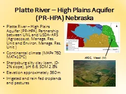
Agroecosyst Manage Res Unit and Environ Manage Res Unit Continental climate MAP 760 MAT10C Sharpsburg silty clay loam 02 slope pH 66 SOM 28 Elevation approximately
Presentation Embed Code
Download Presentation
Download Presentation The PPT/PDF document "Platte River – High Plains Aquifer (PR..." is the property of its rightful owner. Permission is granted to download and print the materials on this website for personal, non-commercial use only, and to display it on your personal computer provided you do not modify the materials and that you retain all copyright notices contained in the materials. By downloading content from our website, you accept the terms of this agreement.
Platte River – High Plains Aquifer (PR-HPA). Partnership: Transcript
Download Rules Of Document
"Platte River – High Plains Aquifer (PR-HPA). Partnership"The content belongs to its owner. You may download and print it for personal use, without modification, and keep all copyright notices. By downloading, you agree to these terms.
Related Documents