/
Boone Forks Wildlife Management Area  - SW Boone Forks Wildlife Management Area  - SW

Boone Forks Wildlife Management Area - SW - PDF document

danika-pritchard
danika-pritchard . @danika-pritchard
Follow
408 views
Uploaded On 2016-12-19

Boone Forks Wildlife Management Area - SW - PPT Presentation

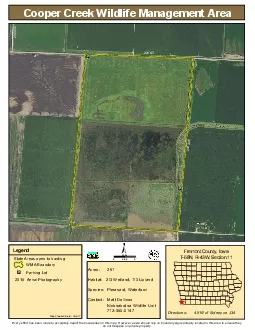
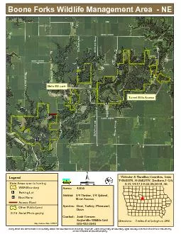
Acres 4517 Habitat 34 Timber 14 Upland River Access Species Deer Turkey Pheasant Dove Contact Josh Gansen Saylorville Wildlife U ID: 503592

^ Acres:

Share:

Link:

Embed:

Download Presentation from below link

Download Pdf The PPT/PDF document "Boone Forks Wildlife Management Area - ..." is the property of its rightful owner. Permission is granted to download and print the materials on this web site for personal, non-commercial use only, and to display it on your personal computer provided you do not modify the materials and that you retain all copyright notices contained in the materials. By downloading content from our website, you accept the terms of this agreement.


Presentation Transcript

^ Boone Forks Wildlife Management Area - NE Acres: 4,655 Habitat: 3/4 Timber, 1/4 Upland, River Access Species: Deer, Turkey, Pheasant, Dove Contact: Josh Gansen Saylorville Wildlife Unit 515-432-2545 ! i ! i ! i ! i ! i ! i ! i ! i ! i ! i ! i Big Bear Road Stagecoach Road 330th Street Bell's Mill Road Evans Road 320th Street Bell's Mill Road Big Bear Road Fenton Avenue Xavier Avenue 300th Street 300th Fenton Avenue Tunnel Mill Road ! y 290th Street 297th 0 0.5 0.25 Miles ± Webster & Hamilton Counties, Iowa T-86&87N, R-26&27W, Sections 1-3,6, 8-11,14-17,19-22,25,30-31,36 Directions: 3 miles E of Lehigh on D46. Legend WMA Boundary ! i Parking Lot ! y Boat Ramp Access Road Other Public Land 2015 Aerial Photography Map Creation Date: 10/2017 State Areas open to hunting Every effort has been made to accurately depict the boundaries on this map. However, users should rely on boundary signs actually located in this area to ensure they do not trespass on private property. Bells Mill park Tunnel Mills Access ^ Boone Forks Wildlife Management Area - SW Acres: 4,655 Habitat: 3/4 Timber, 1/4 Upland, River Access Species: Deer, Turkey, Pheasant, Dove Contact: Josh Gansen Saylorville Wildlife Unit 515-432-2545 ! i ! i ! i ! i ! i ! i ! i ! i ! i ! i ! i ! i Skillet Creek Avenue River Road 340th Street McGuire Bend Avenue Washington Avenue Bellville Road River Road State Highway 175 360th Street 340th Street ! y 0 0.5 0.25 Miles ± Webster County, Iowa T-86&87N, R-26&27W, Sections 1-3,6, 8-11,14-17,19-22,25,30-31,36 Directions: 3 miles E of Lehigh on D46. Legend WMA Boundary ! i Parking Lot ! y Boat Ramp Other Public Land 2015 Aerial Photography Map Creation Date: 10/2017 State Areas open to hunting Every effort has been made to accurately depict the boundaries on this map. However, users should rely on boundary signs actually located in this area to ensure they do not trespass on private property. Skillet Creek Indian Mounds