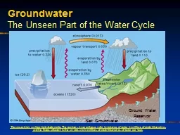
/
DISTRICT GROUNDWATER BROCHURE ERODE DISTRICT, TAMIL NADU A.SUBBURAJ SC DISTRICT GROUNDWATER BROCHURE ERODE DISTRICT, TAMIL NADU A.SUBBURAJ SC

DISTRICT GROUNDWATER BROCHURE ERODE DISTRICT, TAMIL NADU A.SUBBURAJ SC - PDF document

danika-pritchard
danika-pritchard . @danika-pritchard
Follow
423 views
Uploaded On 2016-12-06

DISTRICT GROUNDWATER BROCHURE ERODE DISTRICT, TAMIL NADU A.SUBBURAJ SC - PPT Presentation

For official use Technical Report Series DISTRICT AT A GLANCE ERODE DISTRICT SNO ITEMS STATISTICS 1 GENERAL INFORMATION i Geographical area Sq Km 816191 ii Administrative Divisions AS on ID: 498230

For official use Technical Report Series DISTRICT

Share:

Link:

Embed:

Download Presentation from below link

Download Pdf The PPT/PDF document "DISTRICT GROUNDWATER BROCHURE ERODE DIST..." is the property of its rightful owner. Permission is granted to download and print the materials on this web site for personal, non-commercial use only, and to display it on your personal computer provided you do not modify the materials and that you retain all copyright notices contained in the materials. By downloading content from our website, you accept the terms of this agreement.


Presentation Transcript

DISTRICT GROUNDWATER BROCHURE ERODE DISTRICT, TAMIL NADU A.SUBBURAJ SCIENTIST-D Government of India Ministry of Water Resources Central Ground Water Board South Eastern Coastal Region Chennai April 2008 For official use Technical Report Series DISTRICT AT A GLANCE (ERODE DISTRICT) S.NO ITEMS STATISTICS 1. GENERAL INFORMATION i. Geographical area (Sq. Km) 8161.91 ii. Administrative Divisions AS on (31-3-2007) Number of Tehsils Number of Blocks Number of Town Panchayats Number of Villages 07 20 59 456 iii. Population (As on 2001 Censes) Total Population Male Population Female Population 2581500 1309278 1272222 iv. Average Annual Rainfall (mm) 789.7 (1901 - 1950) GEOMORPHOLOGY i. Major physiographic Units Upland plateau region with hill ranges, isolated hillocks and undulating plain. 2. ii. Major Drainages Cauvery, Bhavani, Noyil, Amaravathi and Palar. 3. LAND USE (Sq. Km) i. Forest area ii. Net area sown iii. Cultivable area 2287 3010 55.6 4. MAJOR SOIL TYPES Red calcareous soil, Red non calcareous soil, Black Soil, Alluvial and Colluvial soils, Brown soil and Forest soil. 5. AREA UNDER PRINCIPAL CROPS INHa(AS ON 31.3.2007)1.Paddy – 43539 (13.41%) 2.Ground nut- 46990 (14.47%) 3.Sugarcane - 41402 (12.75%) 4.Pulsus- 19233 (05.92%) 6. IRIGATION BY DIFFERENT SOURCES Number Area irrigated i. Dug wells122543 52474 ii. Tube wells/ Bore wells 9707 14659 iii. Tanks/Ponds 847 228 iv. Canals 28 91904 v. Other Sources 07 1952 vi. Net irrigated area 161217 vii. Cross irrigated area 184904 NUMBERS OF GROUND WATER MONITORING STATIONWELLS OF CGWB (AS ON 2007) i. No of dug wells 18 7. ii. No of piezometers under Hydrology Project 15 8. PREDOMINANT GEOLOGICAL FORMATIONS Alluvium, Colluvium, Laterite, Granites, Dolerites, Quartzite, Charnockites and Gneisses. 9. HYDROGEOLOGY i. Major water bearing formations Alluvium, Colluvium and weathered, fractured, fissured Crystalline rocks. ii. Pre- monsoon depth to water level (May -2006) 1.76 – 35.69M.bgl iii. Post- monsoon depth to water level (Jan-2007) 1.53 – 16.40 M.bgl Rise (m/year) Fall (m/year) iv. Long term water level trend in 10 years (1997-2006) in m/yr Min.-0.0015 Max.-1.4880 Min.-0.0085 Max.-1.2040 10. GROUND WATER EXPLORATION BY CGWB (As on 31-03-2007) i. Number of Exploratory wells drilled ii. Number of Observation wells drilled iii. Number of Piezometers drilled 69 18 05 iv. Depth range (m) 25.00– 300.00 v. Discharge (Litres per second) 0.078 – 27.00 vi. Specific capacity (Lpm/m) 9.33 – 970.60 vii. Transmissivity (m2/day) 0.053– 457.25 11. GROUND WATER QUALITY i. Presence of chemical constituents more than permissible limit TH as Ca Co3, NO3 ii. Type of water NaCl, Ca-Cl 12. DYNAMIC GROUND WATER RESOURCES (2004) in mcm i. Annual Replenishable Ground Water Resources 769.62 ii. Net Annul Ground Water Draft 1268.26 iii. Projected demand for Domestic and Industrial Uses upto 2025 40.07 iv. Stage of Ground Water Development 135.24 13. AWARENESS AND TRAINING ACTIVITY i. Mass Awareness Programmes Organized NIL Date -- -- Place -- -- No of Participants -- -- ii. Water Management Training Organized NIL Date -- -- Place -- -- No of Participants -- -- 14. EFFORTS OF ARTIFICIAL RECHARGE & RAINWATER HARVESTING i. Projects completed by CGWB Number of structures NIL ii. Projects under technical guidance of CGWB Number of structures NIL 15. GROUND WATER CONTROL AND REGULATION i. Number of OE Blocks 03 ii. Number of Critical Blocks 04 iii. Number of Blocks Notified NIl 16. MAJOR GROUND WATER PROBLEMS AND ISSUS 1)High level of ground water development. 2) Declining of ground water level and drying of shallow wells. 3) Incidence of fluoride in ground water. 4) Local pollution of Surface and ground water by industrial units. 1.0 INTRODUCTION1.1 Administrative Details Erode district is divided into 7 taluks. The taluks are further divided into 20 blocks, which further divided into 549 villages. Table : 1.1 Administrative Set-up of Erode District S.No. Taluk Area (Sq.km) No.of Villages Block Area (Ha.) No.of Villages Erode 16928 41 Madakurichi 34888 29 1 Erode 743.79 94 Kodumudi 22563 24 Bhavani 22036 20 Ammapet 24448 23 2 Bhavani 1503.72 57 Anthiyur 103888 14 Perundurai 29234 48 Chennimalai 28495 24 3 Perundurai 806.21 111 Uthukuli 22892 49 Gobichettipalayam 26991 32 T.N.Palayam 18447 21 4 Gobichetti palayam 703.46 76 Nambiyur 24908 23 Sathiyamangalam 96320 30 Bhavani Sagar 28170 26 5 Sathiyamangalam 2185.70 96 Thalavady 94080 30 Kangayam 34910 20 6 Kangayam 707.84 37 Vellakoil 35874 17 Dharapuram 47401 28 Moolanur 46197 20 7 Dharapuram 1511.19 78 Kundadam 57521 30 District Total 8161.91 549 816191 549 1.2 Basin and sub-basin Major part of the district is falling in part of east flowing Cauvery river basin as per the Irrigation Atlas of India. Palar Maleru, Suvaranvati, Bhavani, R.B.Cauvery, Moyar, Below dam, Kallar, Vanathangarai, Noyil, Vattamalai, Uppar odai, Nangangai, are the sub basins. The district is further sub divided into number of minar basins. 1.3 Drainage The river Cauvery flows along the eastern border of the district. Most of the rivers and streams drained the district form the tributaries to the Cauvery river. The Bhavani river, which has its origin in the Silent Valley range of Kerala State, enters the district about 30 km west of Bhavanisagar and flows more or less in an easterly direction and confluences with the river Cauvery at Bhavani town. Moyar river is a major tributary of the river Bhavani. The river Bhavani is tamed by a reservoir namely the Bhavanisagar. The Palar river originating in the south Bargur forest flows in north-easterly and easterly directions. Maniyar Halla, Tatta Halla, Kathala Halla, Yemahatti Halla and Dinnepattipaliam are the important minor tributaries of the Palar river. The Noyil River draining the southern part of the district has its origin in the Boluvampatty valley of the Vellingiri hills of Western Ghats enter the district flowing from Coimbatore district. The Amaravathi river and its tributaries drain the southern part of the district. It has its origin in Kerala state and passing through the adjoining districts, enters the district at about 5 km south of Salempalayam. The major tributaries to Amaravathi river are the Uppar Odai, Shanmukha Nadi, Nallathangal Odai and Vattamalakkarai. The important streamlets flowing in the northern side are the Bale Halla and Anaikodu Halla, which form tributaries to Suvaranavati river flowing into Karnataka. 1.4 Irrigation Practices Nine fold land use classification of the Erode district (2005-2006) S.No Classification Area (Ha) 1 Forests 228749 2 Barren & Uncultivable Lands 7074 3 Land put to non agricultural uses 80708 4 Cultivable Waste 556 5 Permanent Pastures & other grazing lands 187 6 Groves not included in the area sown 1360 7 Current Fallows 90697 8 Other Fallow Lands 105878 9 Net Area sown 300982 Total 816191 (Source: Department of Economics & Statistics, Govt. of Tamil Nadu) The data available indicate that an area of about 161217 ha, which is about 19.75 percent of the total geographical area of the district is under irrigated agriculture. Canals are the major source of water for irrigation in the district, accounting for about 57.00 percent of the total area irrigated in the district. Dug wells, and bore wells are the accounting for about 32.55 and 9.09 percent of the total area irrigated respectively. Other sources and tanks accounting for about 1.21, and 0.14 percent respectively. It is observed that the well irrigation is the highest in Dharapuram block followed by block Andhiyur. The block wise and source wise net area irrigated in Ha is given below (2005-06). 1.5 Studies/Activities carried out by CGWB The erstwhile Ground Water Wing of the Geological Survey of India (GSI) has carried out hydrogeological surveys in the district. With the assistance of Swedish International Development Authority (SIDA), the Central Ground Water Board (CGWB) completed a water balance project covering Noyil, Ponnani and Amaravathi basins forming parts of and Erode district during the period July 1975 to December 1979. Detailed hydrological, hydrogeological, geophysical, Hydrochemical, soil and water use, quantification of ground water recharge, draft, balance and long-term reserves studies were undertaken in the above multi-disciplinary project. Central Ground Water Board is also carrying out systematic Hydrogeological and Ground Water Management studies and ground water monitoring. Geophysical investigations for assessing the geo-electric characteristics of sub-surface litho-units have also been done by Central Ground Water Board for selection and pin-pointing of sites for exploratory drilling. Central Ground Water Board took up ground water exploration for delineation of aquifers and for assessing their yield characteristics by drilling of exploratory wells during the period 69 exploratory wells, 18 observation wells and 5 piezometers in the depth range of 25 to 300 m.bgl. Were drilled for this purpose in the district. In the Net area irrigated by S.No Block Canals Tanks Tube wells Ordinary wells Other Sources Total Net Area irrigated 1 Ammapet 3658.00 0.00 78.00 4133.00 367.00 8236.00 2 Andhiyur 274.00 0.00 259.00 5598.00 440.00 6571.00 3 Bhavani 6983.00 162.00 140.00 3448.00 768.00 11501.00 4 Bhavanisagar 987.00 0.00 1381.00 1087.00 0.00 3455.00 5 Chennimalai 2612.00 0.00 226.00 1896.00 0.00 4734.00 6 Dharapuram 9285.00 46.00 22.00 5930.00 0.00 15283.00 7 Erode 5996.00 0.00 32.00 483.00 101.00 6612.00 8 Gobichettipalayam 10697.00 20.00 1061.00 2630.00 0.00 14408.00 9 Kangeyam 2589.00 0.00 222.00 2162.00 0.00 4973.00 10 Kodumudi 10871.00 0.00 537.00 1628.00 0.00 13036.00 11 Kundadam 3415.00 0.00 243.00 5410.00 0.00 9068.00 12 Modakurichi 15342.00 0.00 85.00 1628.00 26.00 17081.00 13 Mulanur 793.00 0.00 157.00 2800.00 0.00 3750.00 14 Nambiyur 1440.00 0.00 1396.00 2540.00 0.00 5376.00 15 Perundurai 4838.00 0.000 938.00 1500.00 0.00 7276.00 16 Satyamangalam 3362.00 0.00 4088.00 1836.00 250.00 9536.00 17 T.N.Palayam 4234.00 0.00 562.00 3795.00 0.00 8591.00 18 Thalavadi 0.00 0.00 2801.00 525.00 0.00 3326.00 19 Uthukuli 0.00 0.00 187.00 1146.00 0.00 1333.00 20 Vellakottai 4528.00 0.00 244.00 2299.00 0.00 7071.00 91904 228 14659 52474 1952 161217 more recent past, Central Ground Water Board constructed 8 exploratory wells for drought mitigation through out-sourcing.Under the World Bank Aided Hydrology Project, the CGWB has constructed 30 purpose built observation wells (Piezometers) down to depth ranging from 16.50 to 91.05 m bgl. In additions,Central Ground Water Board has also carried out a number of short – term water supply investigations in the district for various government agencies. 2.0 RAINFALLS AND CLIMATE The district receives the rain under the influence of both southwest and northeast monsoons. The northeast monsoon chiefly contributes to the rainfall in the district. The southwest monsoon is also reasonable. During the winter and hot seasons, the rainfall is scanty. The normal annual rainfall over the district varies from about 575 mm to about 833 mm. It is the minimum in the southern and southeastern parts of the district around Kodumudi (575.3 mm) Mulanur (581.0 mm) and Dharapuram (593.0 mm. It gradually increases towards north and northwest and reaches a maximum around Talavadi (833 mm). The western part of the Erode district enjoys a salubrious climate because of the hilly region, whereas the central and eastern parts of the district are hot and humid. The cooler and pleasant climate prevails in the hilly regions. The weather is extremely pleasant during the period from November to February both in the plains and on the hills. Mornings in general are more humid than the afternoons. The relative humidity varies from 65 to 87 percent during the northeast monsoon period between October and November. The hot weather begins early in March, the highest temperature being reached in April and May. Highest temperatures are recorded during the months of April and May with temperatures reaching 40°C. The weather in the plains during the summer i.e., from April to June is generally dry and hot. Weather cools down progressively from about the middle of June and by December. The night temperatures are the lowest in the hills. 3.0 GEOMORPHYLOGY AND SOIL TYPES 3.1 Geomorphology The Erode district forms part of the uplands of the state. Physiographically the district can be divided into hilly area, the upland area and plains area. The prominent geomorphic units identified in the district through interpretation of Satellite imagery are 1) Structural hills, 2) Inselberg, 3) Ridges, 4) Valley fill, 5) Pediments, 6) Shallow Pediments,. The hilly area is represented by the Western Ghats in the northwestern part of the district, the Biligiri Rangan hills in the north, Bodamalai Betta hills in the northwestern parts and Konbattarayan hills in the north central part of the district. Konbattarayan hill (1699 m above MSL) is the highest peak in the district while Moyar Gorge is a picturesque gorge in the western Ghats through which Moyar river traverses. The Kongunadu uplands lie south of Bhavani river and the Lower Bhavani canal passes through these uplands. Scattered hillocks and knolls of moderate elevations occur within these uplands. The plains area is characterised by an undulating topography with a general gradient due east and southeast. The plains are limited to the east and southwestern border of the district. The plains west of Cauvery river are known as Lower Cauvery plains. 3.2 Soils The soils of Erode district can be broadly classified into 6 major soils types viz., Red calcareous soil, Red non calcareous soil, Black Soil, Alluvial and Colluvial soils, Brown soil and Forest soil. Major part of the district covered by red calcareous soils. They are mostly sandy to loamy and characterised by the hard and compact layer of lime. The red non-calcareous soils are seen in Erode, Perunthurai and Gopichettioalayam taluks. The block soils are occurring as patches in four taluks. Brown soil occupies only a small portion of Bhavani, Kangayam and Gopichettipalayam taluks. Alluvial soils are fund in small patches along the Noyil and Bhavani rivers and the Colluvial soils are found in the foothills of Western Ghats. Forest soil is confined to the reserve forest area in northwestern part of the district, where a surface layer of organic matter is present. 4.0 GROUND WATER SCENARIO 4.1 Hydrogeology Erode district is underlain entirely by Archaean Crystalline formations with Recent alluvial deposits occurring along the river and streams courses and colluvium of valley-fills. The important aquifer systems in the district are constituted by weathered, fissured and fractured crystalline rocks and the recent alluvial deposits. The porous formations in the district are represented by alluvium and colluvium. The alluvial deposits are confined to the major river and stream courses only. Ground water occurs under phreatic conditions. The maximum saturated thickness of these aquifers is upto 5 m depending upon the topographic conditions. The area lying at the foot hill zones which are seen in the northern parts of the district is underlain by the colluvial material derived from the near by hill ranges comprising sands and gravels. The maximum saturated thickness of these aquifers is upto 20 m depending upon the topographic conditions. Ground water occurs under phreatic conditions. The hard consolidated crystalline rocks of Archaean age represent weathered, fissured and fractured formations of gneisses, granites, charnockites and other associated rocks. Ground water occurs under phreatic conditions in the weathered mantle and under semi-confined conditions in the fractured zones. The thickness of the weathered mantle of the hard rocks is varying from less than a meter to as much as 30 m. It is within the depth of 20 m in major part of the district while in the western and extreme north-north-eastern parts of the district, they are more than 20 m. The depth of the wells ranged from 7.00 to 45.00 m bgl. Dug wells have traditionally been the most common ground water abstraction structures. The yields of dug wells used for irrigation ranging from 200 to 400 lpm for drawdown varying from 1 to3 m for a pumping period of 2 to 4 hours. The yields of dug wells are improved at favorable locations by construction of extension bores, which are 40 to 75m. deep. In recent years, the declining water levels and reduction in yields of wells are being observed due to increased extraction of ground water through large number of bore wells for irrigation purposes. The Specific capacity of large diameter wells tested in crystalline rocks from 10.04 to 227.5 lpm / m. of draw down. The transmissivity of weathered formations computed from pumping test data using empirical methods range from 11.96 to 420 m/day. The yield of bore wells drilled down to a depth of 34 to 104 m, by various state agencies mainly for domestic purposes ranged from 20 to 80 gpm. The yield of successful bore wells drilled down to a depth of 300 m bgl during the ground water exploration programme of Central Ground Water Board ranged from 0.078 to 27.00 lps. The aquifer and well parameters of the wells show wide variation The depth to water level in the district varied between 1.76 and 35.69 m bgl during pre-monsoon depth to water level (May 2006) and varied between 1.53 and 16.40 m bgl during post monsoon depth to water level (Jan 2007). The seasonal fluctuation shows a rise in water level, which ranges from 0.04 to 23.37 m bgl. The piezometric head varied between 1.35 to 9.40 m bgl (May 2006) during premonsoon and G.L to 13.00 m bgl during post monsoon. 4.1.1 Long Term Fluctuation (1998-2007) The long-term water level fluctuation for the period 1998-2007 indicates rise in water level in the area 0.0335 - 0.6159 m/year. The fall in water level ranging between 0.0186 - 0.9738 m/year. 4.1.2 Aquifer Parameters The Specific Capacity in the fissured formation ranges from 1.07 lpm/m to 970.6 lpm/m The wells recorded transmissivity values ranging from 0.053 to m/ day to 457.25 m/ day with low to very low permeability values. 4.2 Ground Water Resources The ground water resources have been computed jointly by Central Ground Water Board and State Ground & Surface Water Resources and Development Centre (PWD, WRO, Government of Tamil Nadu) as on 31st March 2004. The salient features of the computations are furnished below. 4.3 Ground Water Quality Ground water in phreatic aquifers in Erode district in general is colorless, odorless and slightly alkaline in nature. The specific electrical conductance of ground water in phreatic zone (in Micro Seimens at 25 o C) during May 2006 was in the range of 660 to 4080 in the district. It is between 750 and 2250 µS/cm at 25°C in the major part of the district. Conductance below 750 µS/cm has been observed in ground water in only one sample is Vellakottai whereas conductance exceeding 2250 µS/cm has been observed at Pudupalayam, Bhavani and Vijayamangalam. Computation of Ground Water Resources of Salem District, Tamil Nadu ( 2004) (in ha.m) ( As per GEC 1997 Methodology) Existing Ground Water Draft Balance Ground Water Available for Future Development stage of Ground water Development Category (As in Jan 2004) S.N Block Net Ground Water Availability Irrigation Draft January-04 Existing Gross ground water draft for Domestic & Industrial Water Supply Allocation for Domestic and Industrial Requirement for next 25 Years Jan-04 Jan-04 Jan-04 1 Ammapet 5718.46 6400.56 237.66 245.85 6638.23 0.00 116 Over Exploited 2 Andhiyur 6964.60 7316.42 118.91 123.01 7435.33 0.00 107 Over Exploited 3 Bhavani 6210.36 3326.65 269.33 278.60 3595.98 2605.11 58 Safe 4 Bhavanisagar 3069.02 2768.78 123.94 128.20 2892.72 172.03 94 Critical 5 Chennimalai 3392.59 1441.17 172.61 178.55 1613.78 1772.87 48 Safe 6 Dharapuram 6800.80 3931.03 197.18 203.97 4128.21 2665.80 61 Safe 7 Erode 4300.32 494.79 502.48 519.78 997.27 3285.75 23 Safe 8 Gobichettipalayam 9816.75 5681.05 254.17 262.92 5935.22 3872.78 60 Safe 9 Kangeyam 3326.36 1856.48 162.86 168.47 2019.34 1301.41 61 Safe 10 Kodumudi 5943.88 2150.11 230.26 238.19 2380.38 3555.58 40 Safe 11 Kundadam 3836.64 1934.58 171.56 177.46 2106.14 1724.59 55 Safe 12 Modakurichi 8606.76 2013.32 277.39 286.94 2290.71 6306.50 27 Safe 13 Mulanur 3323.95 1965.71 139.77 144.58 2105.48 1213.66 63 Safe 14 Nambiyur 3782.41 3874.70 186.34 192.75 4061.04 0.00 107 Over Exploited 15 Perundurai 4499.07 3920.98 254.76 263.53 4175.74 314.56 93 Critical 16 Satyamangalam 6314.11 6054.83 76.33 78.96 6131.16 180.32 97 Critical 17 T.N.Palayam 5856.17 5090.87 141.19 146.05 5232.06 619.25 89 Semi Critical 18 Thalavadi 2255.30 2154.39 28.54 29.52 2182.93 71.39 97 Critical 19 Uthukuli 1537.62 913.79 158.93 164.41 1072.72 459.43 70 Safe 20 Vellakottai 3911.67 1969.58 186.89 193.32 2156.47 1748.77 55 Safe District Total 99466.84 65259.78 3891.09 4025.07 69150.87 30181.99 It is observed that the ground water is suitable for drinking and domestic uses in respect of all the constituents except total Hardness and Nitrate. Total Hardness as CaCo3 is observed to be in excess of permissible limits in about 32 percent of samples analysed, whereas Nitrate is found in excess of 45 mg/l in about 66 percent samples. The incidence of high total hardness is attributed to the composition of lithounits constituting the aquifers in the district, whereas the nitrate pollution is most likely due to the use of fertilizers for agriculture and other improper waste disposal. With regard to irrigation suitability based on specific electrical conductance and sodium Absorption Ratio (SAR), it is observed that ground water in the phreatic zone may cause high to very high salinity hazard and medium to high alkali hazard when used for irrigation. Proper soil management strategies are to be adopted in the major part of the district while ground water foe irrigation. 4.4 Status of Ground Water Development The estimation of groundwater resources for the district has shown that 3 blocks are over exploited and 3 blocks are under “critical” category. Tamil Nadu Water Supply and Drainage (TWAD) Board is the Government agency responsible for providing drinking water supplies to the urban and rural populace in the district. The water requirements of the habitations are met with either through surface water sources or through various Mini Water Supply Schemes or Integrated water supply schemes utilising the available ground water resources. The status of urban and rural water supply in the district is furnished below Total Number of Rural Habitants : 5092 Not Covered : 26 (0-9 Lpcd) Partly Covered : 2489 (10-39 Lpcd) Fully Covered : 2577 (40 Lpcd and above) The habitants of 10 Municipalities of the district are provided with 70 - 90 Lpcd water and the habitants 24 town Panchayats and 30 rural Panchayats are provided with 30 – 70 and 40 – 70 Lpcd water respectively. Dug wells have traditionally been the most common ground water abstraction structures used for irrigation in the district, with yields ranging from 50 to 200 /day in weathered crystalline rocks and up to 400 m3/day in Recent alluvial and colluvial formations along major drainage courses and valleys.5.0 GROUNDWATER MANAGEMENT STRATEGY 5.1 Groundwater Development In view of the comparatively high level of ground water development in the major part of the district and the quality problems due to geogenic and anthropogenic factors, it is necessary to exercise caution while planning further development of available ground water resources in the district. The development of ground water for irrigation in the district is mainly through dug wells tapping the weathered residuum. The yields of dug wells are improved at favorable locations by construction of extension bores, which are 40 to 75 m deep. Bore wells have also become popular as the source for irrigation in the district in recent years. Dug wells with extension bores wherever necessary is ideal for hard rock areas. The map showing the development prospects for the district is shown in Plate VI. 5.2 Water Conservation and Artificial Recharge On the basis of experimental studies, it has been found that desilting of existing tanks followed by percolation pond with recharge wells, recharge shafts are economical. Accordingly, computations have been made for Drought Prone Area Programme (DPAP). Over exploited and Critical blocks in the districts warranting immediate attention. A summary giving the availability of surface run off, number of structures feasible and cost estimates for the schemes is provided in the table. There is considerable scope for implementation of roof – top rainwater harvesting in the district. Recharge pits / Shafts / trenches of suitable design are ideal structures for rainwater harvesting in such areas. Free technical guidance for implementation of rooftop rain water harvesting schemes is also being provided by Central Ground Water Board. 6.0 GROUNDWATER RELATED ISSUES & PROBLEMS The ground water development in the district, in general, is moderate when compared to many other districts in the state. As many as 3 out of 20 blocks in the district have been categorised as either ‘OVEREXPLOITED’ or ‘DARK’. The trend analysis of historical ground water level data also indicates a long-term fall in a part of the district. Based on the factors mentioned, it is inferred that a part of the district could be considered vulnerable to various environmental impacts of water level depletion such as declining ground water levels, drying up of shallow wells, decrease in yield of bore wells and increased expenditure and power consumption for drawing water from progressively greater depths. The ground water pollution in this district is due to the indiscriminate discharge of untreated effluents from the textiles dyeing, bleaching processing and tanneries units, which are concentrated at Erode, Bhavani, Chennimalai and Vellakoil towns and their environs. This has affected the quality of the formation in the shallow aquifers, thereby rendering unsuitable for drinking purposes. Excessive use of fertilisers and pesticides in the areas with intensive irrigation practices has also reportedly resulted in localised enrichment of nitrate and other harmful chemicals in the ground water, especially in the phreatic zone. Incidence of fluoride in ground water in excess of permissible limits for drinking has been reported from parts of the district, especially from the fracture zone. The source of fluoride in ground water is the fluoride-bearing minerals present in the granitic gneisses and granites, which underlie in the area. 7.0 AREA NOTIFIED BY CGWA/SGWA Central Ground Water Authority has not notified any area in the district. Government of Tamil Nadu vide G.O.No. 53 has banned groundwater development for irrigation in the over exploited blocks of Tamil Nadu. The over exploited blocks in this district are Ammapet – E, Andhiyur, Nambiyur. 8.0 RECOMMENDATIONS As the development of ground water has already reached an alarming stage in some of the blocks, further development of ground water for creation of additional irrigation potential has to be carried out with extreme caution. Necessary measures for regulation of ground water abstraction from over-exploited and critical blocks may be initiated without further delay. Detailed studies on the extent of pollution by industrial units in the district may be taken up to assess the damage to the ground water resources in the area and to understand the migration of pollutants. A network of observation wells may be established in the area to monitor the water quality on a regular basis. Artificial recharge of ground water through cost-effective rainwater harvesting systems may be popularised in the district by providing incentives to individuals/communities embarking upon such initiatives. A concerted effort involving various Government agencies and NGOs can create the necessary awareness among the rural masses. Steps be taken up to evolve suitable measures for desilting the existing irrigation tanks and supply channels to improve their longevity and for augmenting the storage of rain waters which in turn will induce the ground water recharge. LEGEND PLATE FOR -VI DISTRICT – ERODE OTHER INFORMATION Geographical Area 8162 Sq. Km. No. of Blocks 20 Major Drainage Cauvery, Bhavani, Noyil, Vattamalai Karai, Uppar Odai & Nangangi Population (2001) 25,74,067 Average Annual Rainfall 666 Mm Annual Range Of Temperature 26 –37°C Regional Geology Hard Rocks: Charnockite, Hornblend Biotite Gneiss & Granite Net Ground Water Availability for Future Irrigation 313 MCM/Yr Stage of Ground Water Development( As On march 2004) 69 % Name of Blocks showing Intensive Ground Water Development v. Over-Exploited: Ammapet, Andhiyur & Nambiyr Critical: Bhavanisagar, Sathiyamangalam & Talavadi , Wells Feasible Rigs Suitable Depth of Well (M) Discharge (LPM) Suitable Artificial Recharge Structures Hard Rock Aquifer Dug Well Bore Well Manual DTH 15 - 20 60 – 150 10 - 60 20 – 100 Check Dams/ Gully Plug Hard Rock Aquifer Dug Well Bore Well Manual Dth 15 - 20 75 - 180 60 – 100 80 – 120 Check Dams/ Farm Pond /Gully Plug Hard Rock Aquifer Dug Well Bore Well Manual Dth 15 - 20 75 - 180 100 – 200 100 - 250 Check Dams/ Farm Pond /Gully Plug State Boundary District Boundary Hilly Area Block Boundary District Headquarter Block Headquarters 5 Water Level-Pre-Monsoon (Decadal Mean 1993-2002) Mbgl 1250 EC In Microsiemens / Cm At 25°C River Lineament Fluoride Greater Than Maximum Permissible Limit (1.5 mg/L) Nitrate Greater Than Maximum Permissible Limit (45 mg/L)  Recommended Site For Artificial Recharge Structure Published by : Regional Director, CGWB, SECR, E-1, Rajaji Bhavan, Besant Nagar, Chennai-90 +914424912941/24914494 /Fax : 91 4424914334 Web: www.cgwb.gov.in rdsecr-cgwb@nic.in