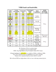
PDF-VIIRS bands and bandwidths VIIRS Band Central Waveleng
Author : debby-jeon | Published Date : 2015-05-03
412 002 0402 0422 Visible Reflective 750 m M2 0445 0018 0436 0454 M3 0488 002 0478 0488 M4 0555 002 0545 0565 M5 B 0672 002 0662 0682 M6 0746 0015 0739 0754 Near
Presentation Embed Code
Download Presentation
Download Presentation The PPT/PDF document "VIIRS bands and bandwidths VIIRS Band Ce..." is the property of its rightful owner. Permission is granted to download and print the materials on this website for personal, non-commercial use only, and to display it on your personal computer provided you do not modify the materials and that you retain all copyright notices contained in the materials. By downloading content from our website, you accept the terms of this agreement.
VIIRS bands and bandwidths VIIRS Band Central Waveleng: Transcript
412 002 0402 0422 Visible Reflective 750 m M2 0445 0018 0436 0454 M3 0488 002 0478 0488 M4 0555 002 0545 0565 M5 B 0672 002 0662 0682 M6 0746 0015 0739 0754 Near IR M7 G 0865 0039 0846 0885 M8 1240 0020 123 125 Shortwave IR M9 1378 0015 1371 1386 M10. VIIRS Aerosol Cal/Val Team. VIIRS Aerosol Science and Operational Users Workshop November 21-22, 2013. 1. Outline. VIIRS Aerosol Products. Environmental Data Record (EDR). Intermediate Product (IP). Istvan. Laszlo. NOAA. VIIRS Aerosol Science and Operational Users Workshop . November 21-22, 2013. . National Center for Weather and Climate Prediction (NCWCP). College Park, MD. Name. Organization. Nightfire. July 24, 2013. NOAA-NGDC Earth Observation Group. chris.elvidge@noaa.gov. Background. The blaze began about 10:50 p.m. local time . , July 23, on . the Hercules 265 natural gas platform, which is located around 55 miles off the Louisiana coast in the Gulf of Mexico.. On-Orbit Calibration for. Ocean Color Applications. MODIS / VIIRS Science Team Meeting. May 2015. Gene Eplee, Kevin Turpie,. Gerhard Meister, and Fred Patt. NASA Ocean Biology. Processing Group. 2. OBPG VIIRS On-Orbit Calibration Methodology. McIDAS. -V . Powerhouse Fire. June 2-3. William Straka III. 1. VIIRS DNB. June 2, 2013 0822Z. Powerhouse. Thompson Ridge. Tres. Lagunas. VIIRS (3.9. m. m). June 2, 2013 0822Z. Powerhouse. Thompson Ridge. MUH 271 Jazz History. Jazz In the 1920s. much of the most popular music called jazz reflects a "slapstick" phase.. new interest in the blues.. "As jazz expands in the 1920s, it becomes increasingly difficult to sort out the many strands of direct or indirect influences, of concurrent or successive developments, and of regional musical-social characteristics" (Schuller 1968, p. 242).. VIIRS Cloud Phase Validation . The VIIRS cloud phase algorithm was validated using a 24-hour period on November 10, 2012.. Validation was performed using collocated CALIPSO data for pixels detected as cloud from both the VIIRS and CALIPSO cloud masks.. Please ensure your sound is on for the coming slides.. If not viewing in slide show mode, hover over the bottom. right hand corner of the slide to play sound. . What is Heavy Metal?. Booming, Thunderous Bass. Active Fires is one of the operational environmental data products generated from . VIIRS on . the . SNPP . satellite. The standard . product . generated by the SNPP Interface Data Processing Segment (IDPS), processes radiometric measurements from the VIIRS 750m moderate resolution bands using a heritage algorithm from . 1 MODIS and VIIRS Instrument Status Jack Xiong and Jim Butler Code 618.0, NASA Goddard Space Flight Center, Greenbelt, MD 20771 MODIS and VIIRS Science Team Meeting, Silver Spring, MD (June 06-10, 2016) Robert C. Levy (NASA-GSFC). robert.c.levy@nasa.gov. Shana . Mattoo. , Leigh . Munchak. . and Richard . Kleidman. . (SSAI/GSFC). Lorraine Remer. . (UMBC/JCET), . Falguni. . Patadia. (MSU/GSFC), . Eric Vermote. NASA GSFC Code 619. eric.f.vermote@nasa.gov. . . . . MODIS/VIIRS Science Team Meeting, June 6-June 10, Silver Spring, MD. A Land Climate Data Record. Multi instrument/Multi sensor Science Quality Data Records used to quantify trends and changes. Properties . Beta . Maturity. DR # . 7154. CCR # . 1075. DRAT discussion. : . 4/17. /. 2013. AERB presentation: . June 12, 2013. Cloud Properties Products Team. Andrew Heidinger, NOAA/NESDIS/STAR, Team Lead. VIIRS I-band 1 Visible (375 m) – 30 June 2014 – Paraguay Flooding. Left: SNPP/VIIRS false-color image (Composited by Imager bands 3, 2, 1) on June 30, 2014 17:02 (UTC). Right: SNPP/VIIRS flood detection map on .
Download Document
Here is the link to download the presentation.
"VIIRS bands and bandwidths VIIRS Band Central Waveleng"The content belongs to its owner. You may download and print it for personal use, without modification, and keep all copyright notices. By downloading, you agree to these terms.
Related Documents