/
Hiking Into Grand Canyon Hiking Into Grand Canyon

Hiking Into Grand Canyon - PDF document

eleanor
eleanor . @eleanor
Follow
342 views
Uploaded On 2021-08-15

Hiking Into Grand Canyon - PPT Presentation

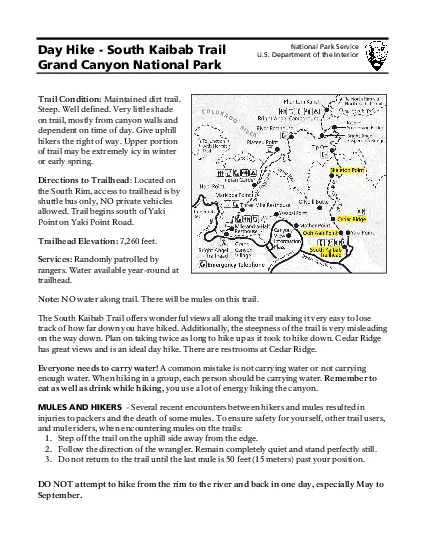
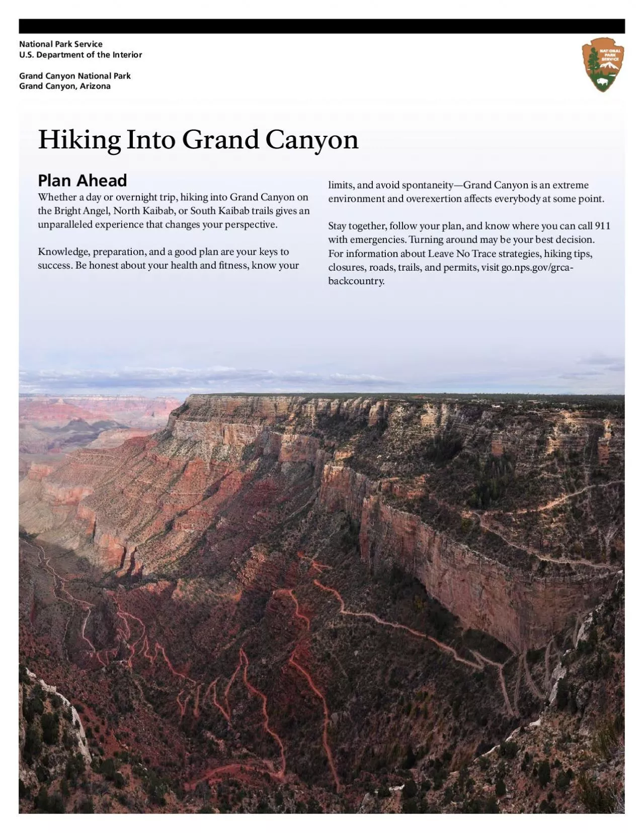
Plan AheadWhether a day or overnight trip hiking into Grand Canyon on the Bright Angel North Kaibab or South Kaibab trails gives an unparalleled experience that changes your perspective Knowledge prep ID: 863559

trail 149 angel kaibab 149 trail kaibab angel hiking bright water creek trailhead 150 north hike weather elevation canyon

Share:

Link:

Embed:

Download Presentation from below link

Download Pdf The PPT/PDF document "Hiking Into Grand Canyon" is the property of its rightful owner. Permission is granted to download and print the materials on this web site for personal, non-commercial use only, and to display it on your personal computer provided you do not modify the materials and that you retain all copyright notices contained in the materials. By downloading content from our website, you accept the terms of this agreement.


Presentation Transcript

1 Hiking Into Grand Canyon Plan Ahead Whet
Hiking Into Grand Canyon Plan Ahead Whether a day or overnight trip, hiking into Grand Canyon on the Bright Angel, North Kaibab, or South Kaibab trails gives an unparalleled experience that changes your perspective. Knowledge, preparation, and a good plan are your keys to success. Be honest about your health and tness, know your limits, and avoid spontaneity—Grand Canyon is an extreme environment and overexertion aects everybody at some point. Stay together, follow your plan, and know where you can call 911 with emergencies. Turning around may be your best decision. For information about Leave No Trace strategies, hiking tips, closures, roads, trails, and permits, visit go.nps.gov/grca- backcountry. National Park Service U.S. Department of the Interior Grand Canyon National Park Grand Canyon, Arizona Before You Go • Choose the appropriate trail for your abilities or consider walking the Rim Trail for an easier hike. • Check the weather and adjust plans; avoid summer heat. Remember the weather can change suddenly. • Leave your itinerary with someone who will notice if you are overdue and report it to 911. • Hydrate, but don’t force uids. Eat a good meal, and get a good night’s sleep. If you do not feel well, do not hike. • Prepare yourself for a faster hike down with high impact on your joints and a slow, strenuous hike out that may take twice as long or longer. that may take twice as long or longer. While Hiking BALANCE FOOD AND WATER • Do not force uids. Drink water when you are thirsty, and stop when you are quenched. Over-hydration may lead to a life-threatening electrolyte disorder called hyponatremia. RESTORE YOUR ENERGY • Eat double your normal intake of carbohydrates and salty foods. Calories play an important role in regulating body temperature, and hiking suppresses your appetite. TAKE CARE OF YOUR BODY • If you start to feel nauseated, dizzy, or disoriented, rest, eat, and drink until you feel better. This can take an hour or longer. • If you are hot, cool o by getting wet in creeks and water stations. If you are cold, put on layers and eat food. • Take plenty of breaks and enjoy the view while resting. 10 Essentials for Your Day Pack 1. Water: bring a sucient amount and extra in case of emergency; always bring a water treatment method 2. Salty snacks and high-calorie meal(s) 3. First aid kit, prescriptions, blister care, duct tape, and pocket knife 4. Map or trail guide 5. Flashlight or headlamp with spare batteries 6. Sunscreen, wide-brimmed hat, and sunglasses 7. Whistle, signal mirror, and cell phone 8. Lightweight tarp or emergency shelter 9. Broken-in hiking shoes with good soles and hiking poles 10. Layers of clothing Warning Hiking to the river and back in one day is not recommended due to long distance, extreme temperature changes, and an approximately 5,000- foot (1,500 m) elevation change each way. If you think you have the tness and expertise to attempt this extremely strenuous hike, please seek the advice of a park ranger at the Backcountry Information Center. Know how to rescue yourself. YOU are responsible for your safety and the safety of your family and friends. Rescue is not guaranteed, and assistance may take hours or days due to weather or other emergencies. SUMMER Plan for hot, mostly dry weather in May and September; extremely hot, dry weather in June; and hot with monsoon thunderstorms in July and Augus

2 t. Average temperatures at the top: 48
t. Average temperatures at the top: 48°F to 83°F (9°C to 28°C) Average temperatures at the river: 74°F to 104°F (23°C to 40°C); temperatures can feel like 140°F (60°C) in the sun and reach 115°F (46°C) in the shade. Hiking Tips • Start hiking before dawn, in the evening, or at night to avoid dangerous heat. Do not hike between 10 am and 4 pm. • Wear light-colored, loose-tting cotton clothing. Soak your shirt, bandana, and hat to stay cool. • Beware of lightning, falling rocks, and ash oods during storms. Stay away from edges, promontories, and individual trees. • Know the signs of heat illness: headaches, dizziness, nausea and vomiting, cramping, and decreased urine output. Rest in the shade, get wet, hydrate, and eat high- energy foods. • Know the signs of hyponatremia, caused by over-hydration: nausea and vomiting, headache, diculty walking, confusion, and seizures. Balance hydration with salty snacks, eat well-rounded meals, and rest frequently. SPRING AND AUTUMN Plan for short days with highly variable weather. While the climate is typically cool, it can snow or be intensely hot. High winds are common. Average temperatures at the top: 32°F to 63°F (0°C to 17°C) Average temperatures at the river: 56°F to 82°F (13°C to 28°C) Hiking Tips • If the weather is hot, follow summer hiking tips at left. • Prepare for lingering ice in spring and early snow in autumn. Bring over-the- shoe traction devices. • Check water availability along the Bright Angel and North Kaibab trails. Seasonal water is usually available May through September. • Wear windproof layers on windy days. • Stay aware—hypothermia can occur in 50°F (10°C) weather and heat illness in 80°F (27°C) weather. WINTER Plan for short days and long, cold nights with potential snow and ice at the top and rain in the canyon. The upper portion of all trails can be icy and dangerous. The South Kaibab Trail receives more sun than the Bright Angel Trail. Average temperatures at the top: 19°F to 45°F (-7°C to 7°C) Average temperatures at the river: 38°F to 59°F (3°C to 15°C) Hiking Tips • Carry over-the-shoe traction devices and use them on icy trails. • Wear a warm hat, gloves, wool socks, and synthetic or wool-blend layers. Pack waterproof layers, dry clothes, and socks. • Eat warm foods often, such as soup, tea, cocoa, and oatmeal. • Know the signs of hypothermia: uncontrolled shivering, confusion, and exhaustion. Put on dry clothing, drink warm liquids, and protect yourself from wind, rain, snow, and cold. What to Expect Each Season Hiking and Camping Information South Kaibab Trailhead: elevation 7200ft (2195m) Destination Elevation Changefrom Top Distance one-way Time Roundtrip Ooh Aah Point 790ft (230m) 0.9mi (1.4km) 1–2 hours Cedar Ridge 1120ft (340m) 1.5mi (2.4km) 2–4 hours Skeleton Point 2040ft (620m) 3.0mi (4.8km) 4–6 hours The Tip Off 3280ft (1100m) 4.4mi (7.1km) 6–9 hours North Kaibab Trail junction 4700ft (1430m) 6.8mi (10.9km) 2 Days Bright Angel Campground 4700ft (1430m) 7.0mi (11.3km) 2 Days The Bright Angel Trail follows Bright Angel Fault down Garden Creek Canyon on a well- maintained trail; ”easiest” trail, but still incredibly steep. North Kaibab Trailhead: elevation 8240ft (2511m) Destination Elevation Change from Top Distance one-way Time Roundtrip Coconino Overlook 790ft (240m) 0.7mi (1.1km) 1–2

3 hours Supai Tunnel 1400ft (425m) 2.0mi (
hours Supai Tunnel 1400ft (425m) 2.0mi (3.2km) 2–4 hours Redwall Bridge 2200ft (670m) 2.6mi (4.2km) 4–6 hours Roaring Springs Day Use Area 3280ft (1000m) 4.7mi (7.6km) 6–9 hours Manzanita Rest Area 3840ft (1170m) 5.1mi (8.2km) 7–10 hours Cottonwood Campground 4200ft (1280m) 6.5mi (10.5km) 2 days Ribbon Falls 4480ft (1365m) 7.9mi (12.7km) 2 days Phantom Ranch Ranger Station 5740ft (1750m) 13.6mi (21.9km) 3–4 days Bright Angel Campground 5740ft (1750m) 13.7mi (22.0km) 3–4 days Bright Angel Trailhead: elevation 6840ft (2085m) Destination Elevation Change from Top Distance one-way Time Roundtrip Lower Tunnel 590ft (180m) 0.9mi (1.4km) 1–2 hours 1½-Mile Resthouse 1120ft (340m) 1.5mi (2.4km) 2–4 hours 3-Mile Resthouse 2120ft (645m) 3.0mi (4.8km) 4–6 hours Indian Garden Campground 3040ft (925m) 4.5mi (7.2km) 6–9 hours Plateau Point 3080ft (940m) 6.1mi (9.8km) 9–12 hours River Resthouse 4340ft (1320m) 7.7mi (12.4km) 12+ hours North Kaibab Trail junction 4340ft (1320m) 9.3mi (15.0km) 2 days Bright Angel Campground 4340ft (1320m) 9.5mi (15.3km) 2 Days Hiking and Camping Information Cont. Have Fun Be Careful Seek AdviceNorth Kaibab TrailheadCoconino OverlookSupai TunnelRedwall BridgeRoaring SpringsDay Use AreaManzanita Rest AreaCottonwood CampgroundRibbon FallsBright Angel CampgroundTip OffSouth Kaibab TrailheadSkeleton PointCedar RidgeOoh Aah PointRiver ResthouseIndian Garden Campground3-Mile Resthouse1½-Mile ResthouseLower TunnelUpper TunnelBright Angel Trailhead Trail Courtesy 1. Travel with a friend and stick together. 2. Use toilets along the trails. 3. Mules have the right of way. 4. Uphill hikers have the right of way. 5. To pass someone in front of you: slow down and let them know you want to pass. 6. Do not store or abandon gear along the trail; it attracts wildlife. 7. Pack out your trash. 8. Be quiet and respect those who seek serenity. The North Kaibab Trail travels through pine forests and rock outcroppings down Roaring Springs Canyon on a well-maintained trail. The South Kaibab Trail follows an exposed ridge line with no shade on a well-maintained trail; best views during a short hike. Trail Map Tiyo Point Claude Birdseye Point Lyell ButtePLATEAUPLATEAUYaki PointYavapai Point Osiris Temple Komo Point2454 m Village Loop DriveTo South Entrance Station and TusayanTo Hermits RestTo Desert View and CameronTo North EntranceTo Point ImperialIndian GardenLower TunnelThe Tipoff1146 mEl TovarVerkamps Visitor CenterSupai TunnelManzanita Rest AreaOfceNORTH RIMServices available year-round.South Kaibab Trailhead closed River! You could drown due to Trailhead Trailhead Trailhead 67 000.50.51 Mile1 Kilometer Ranger Station: Year-roundToilet Drinking Water: Seasonal; checkDrinking Water: Year-Round Noh Other trail Featured trail Road Food service Purple shuttle route Blue shuttle route Red shuttle route Orange shuttle route from topTime round-tripSupai Tunnel North Kaibab Trail:Trailhead elevation 824Good shade and cover from wind and lightning; seasonal water. from topTime round-tripLower TunnelNorth Kaibab Trail junctionBright Angel Trail: Trailhead elevation 684Some shade and cover from wind and lightning; seasonal and year-round water. from topTime round-tripThe TipoffNorth Kaibab Trail junction South Kaibab Trail:Trailhead elevation 720Follows an exposed ridgeline with no shade; no water. Be carefulexperienced hikers only. Hiking to change each way. If you think you Information Center. TunnelUpper Tunnel6250ft 1905mEl Tov

4 arTrailviewVerkampsTo Indian Garden, Pla
arTrailviewVerkampsTo Indian Garden, Plateau Point, Trailhead 0200 Meters01000 Feet Afternoon amphitheaterreservations required)CampgroundTunnelRiver! You could drown due toTrail To South Kaibab TrailheadTo Cottonwood Campground and North RimTo Indian Garden andBright Angel Trailhead Noh 0100 Meters0500 Feet Upper Bright Angel Trail Plan your Hike Dragon Creek Creek Colorado River Pipe Creek Cremation Creek Grapevine Creek Phantom Creek Creek Creek Manzanita Wall Creek Angel Bright Creek Angel Bright Bright Angel Creek Bright Angel Wash Creek Garden Ribbon Falls GraniteRapids Pipe CreekRapids GrapevineRapids While at Camp • Choose your campsite. Sites are rst- come, rst-served with the required permit. Large group sites are reserved for parties of 7–11 hikers. • Immediately place all food, toiletries, and plastic bags in the food storage cans at each campsite. Keep the lids closed and fastened shut at all times. Hang your backpack with the zippers open to prevent animals from chewing through your pack. • Place your backcountry permit in the box provided. Leave your permit at your site during your entire stay. • Use headlamps with red lights to preserve your night vision, minimize light pollution, and avoid disturbing other campers. When Leaving Camp • If you start early, remember to maintain a quiet camp and let fellow campers sleep. • Do not leave any trash, gear, or extra food behind. Check your site for microtrash —look for bandages, twist ties, fruit peels, etc. • Remove everything from the food storage cans. • Attach your permit to your backpack for your hike out. • Check the campground bulletin boards for weather, trail, and water updates. Prepare: Plan Ahead • Backpackers planning to camp overnight must obtain a backcountry permit before starting their hike Attach the permit visibly to your backpack. Camp only in campgrounds, not along the trail. No campres allowed. • In addition to the 10 essentials listed above, bring a stove, fuel, and matches; blanket or sleeping bag with ground pad; and ground cloth, tarp, or tent. • Pack weight should not be more than 15–20% of your body weight. In summer, pack light—replace your sleeping bag with a liner or sheet; bring ready-to-eat foods and leave the stove behind. • Watch and review the Hiking Grand Canyon, Prepare for Backpacking video, available at go.nps.gov/grca- backcountry-video. Overnight Camping on the Bright Angel, North Kaibab, and South Kaibab Trails Dragon Creek Creek Colorado River Pipe Creek Cremation Creek Grapevine Creek Phantom Creek Creek Creek Manzanita Wall Creek Angel Bright Creek Angel Bright Bright Angel Creek Bright Angel Wash Creek Garden Ribbon Falls GraniteRapids Pipe CreekRapids GrapevineRapids National Park ServiceU.S. Department of the InteriorGrand Canyon National ParkGrand Canyon, Arizona While at Camp • Choose your campsite. Sites are rst-come, rst-served with the required permit. Large group sites are reserved for parties of 7–11 hikers. • Immediately place all food, toiletries, and plastic bags in the food storage cans at each campsite. Keep the lids closed and fastened shut at all times. Hang your backpack with the zippers open to prevent animals from chewing through you

5 r pack. • Place your backcountry
r pack. • Place your backcountry permit in the box provided. Leave your permit at your site during your entire stay. • Use headlamps with red lights to preserve your night vision, minimize light pollution, and avoid disturbing other • If you start early, remember to maintain a quiet camp and let fellow campers sleep. • Do not leave any trash, gear, or extra food behind. Check your site for microtrash —look for bandages, twist ties, fruit peels, etc. • Remove everything from the food storage cans. • Attach your permit to your backpack for your hike out. • Check the campground bulletin boards for weather, trail, and water updates. Prepare: Plan Ahead • Backpackers planning tocamp overnight must obtain a backcountry permit before starting their hike Attach the permit visibly to your backpack. Camp only in campgrounds, not along the trail. No campres allowed. • In addition to the 10 essentials listed above, bring a stove, fuel, and matches; blanket or sleeping bag with ground pad; and ground cloth, tarp, or tent. • Pack weight should not be more than 15–20% of your body weight. In summer, pack light—replace your sleeping bag with a liner or sheet; bring ready-to-eat foods and leave the stove behind. • Watch and review the Hiking Grand Canyon, Prepare for Backpacking video, available at go.nps.gov/grca-backcountry-video.Overnight Camping on the Bright Angel, Trail Map Tiyo Point Claude Birdseye Point Lyell ButtePLATEAUPLATEAUYaki PointYavapai Point Osiris Temple Komo Point2454 m riVillage Loop DriveTo South Entrance Station and TusayanTo Hermits RestTo Desert View and CameronTo North EntranceTo Point ImperialIndian GardenLower Tunnel1½The Tipoff1146 mEl TovarVerkamps Visitor CenterSupai TunnelManzanita Rest AreaOfceNORTH RIMServices available year-round.South Kaibab Trailhead closedkmkmkmkmkmkmkmkmkmkmkmkmkmkmkmkmkmkmkmkmkmkmkmkmkmkm1km7kmkmkmkmkmkm River! You could drown due to Trailhead Trailhead Trailhead 67 000.50.51 Mile1 Kilometer Ranger Station: Year-roundToilet Drinking Water: Seasonal; checkDrinking Water: Year-Round North Other trail Featured trail Road Food service Purple shuttle route Blue shuttle route Red shuttle route Orange shuttle route from topDistance one-wayTime round-tripSupai Tunnel240m425m670m1170m1280m1365m1750m1750m790ft1400ft2200ft3840ft4200ft4480ft5740ft5740ft1.1km3.2km4.2km8.2km10.5km12.7km22.0km0.7mi2.0mi2.6mi5.1mi6.5mi7.9mi13.6mi13.7mi North Kaibab Trail:Trailhead elevation 824Good shade and cover from wind and lightning; seasonal water. from topDistance one-wayTime round-tripLower TunnelNorth Kaibab Trail junction180m340m645m925m940m1320m1320m1320m590ft1120ft2120ft3040ft3080ft 4340ft4340ft4340ft1.6km2.4km4.8km7.2km9.8km12.6km15.3km1.0mi1.5mi3.0mi4.5mi6.1mi7.8mi9.3mi9.5miBright Angel Trail: Trailhead elevation 684Some shade and cover from wind and lightning; seasonal and year-round water. from topDistance one-wayTime round-tripThe TipoffNorth Kaibab Trail junction230m340m620m1100m1430m1430m790ft1120ft2040ft3280ft4700ft4700ft1.4km2.4km4.8km7.2km11.3km0.9mi1.5mi3.0mi4.5mi6.8mi7.0mi South Kaibab Trail:Trailhead elevation 720Follows an exposed ridgeline with no shade; no water. Be carefulexperienced hikers only. Hiking to change each way. If you think you Information Center. TunnelUpper Tunnel6250ft 1905mEl TovarTrailviewVerkampsTo Indian Garden, Plateau Point,1½ Trailhead 0200 Meters01000 Feet Afternoon amphitheaterreservations required)CampgroundTunnelRiver! You could drow

6 n due toTrail To South Kaibab TrailheadT
n due toTrail To South Kaibab TrailheadTo Cottonwood Campground and North RimTo Indian Garden andBright Angel Trailhead North 0100 Meters0500 Feet Upper Bright Angel Trail Plan your Hike Hiking and Camping Information Cont. Have Fun Be Careful North Kaibab TrailheadSupai TunnelTip OffSouth Kaibab TrailheadLower TunnelUpper TunnelBright Angel Trailhead Trail Courtesy 1. Travel with a friend and stick together. 2. Use toilets along the trails. 3. Mules have the right of way. 4. Uphill hikers have the right of way. 5. To pass someone in front of you: slow down and let them know you want to pass. 6. Do not store or abandon gear along the trail; it attracts wildlife. 7. Pack out your trash. 8. Be quiet and respect those who seek serenity. The North Kaibab Trail travels through pine forests and rock outcroppings down Roaring The South Kaibab Trail follows an exposed ridge line with no shade on a well-maintained trail; Hiking and Camping South Kaibab Trailhead: elevation 7200ft (2195m)Elevation Changefrom TopTime RoundtripThe Tip OffNorth Kaibab Trail The Bright Angel Trail follows Bright Angel Fault down Garden Creek Canyon on a well-incredibly steep. North Kaibab Trailhead: elevation 8240ft (2511m)Elevation Change from TopTime RoundtripSupai Tunnel Bright Angel Trailhead: elevation 6840ft (2085m)Elevation Change from TopTime RoundtripLower TunnelNorth Kaibab Trail SUMMER Plan for hot, mostly dry weather in May and September; extremely hot, dry weather in June; and hot with monsoon thunderstorms in July and August.Average temperatures at the top: 48°F to 83°F (9°C to 28°C) Average temperatures at the river: 74°F to 104°F (23°C to 40°C); temperatures can feel like 140°F (60°C) in the sun and reach 115°F (46°C) in the shade. • Start hiking before dawn, in the evening, or at night to avoid dangerous heat. Do not hike between 10 am and 4 pm. • Wear light-colored, loose-tting cotton clothing. Soak your shirt, bandana, and hat to stay cool. • Beware of lightning, falling rocks, and ash oods during storms. Stay away from edges, promontories, and individual trees. • Know the signs of heat illness: headaches, dizziness, nausea and vomiting, cramping, and decreased urine output. Rest in the shade, get wet, hydrate, and eat high-energy foods. • Know the signs of hyponatremia, caused by over-hydration: nausea and vomiting, headache, diculty walking, confusion, and seizures. Balance hydration with salty snacks, eat well-rounded meals, and rest frequently. SPRING AND AUTUMN Plan for short days with highly variable weather. While the climate is typically cool, it can snow or be intensely hot. High winds are common.Average temperatures at the top: 32°F to 63°F (0°C to 17°C) Average temperatures at the river: 56°F to 82°F (13°C to 28°C) • If the weather is hot, follow summer hiking tips at left. • Prepare for lingering ice in spring and early snow in autumn. Bring over-the-shoe traction devices. • Check water availability along the Bright Angel and North Kaibab trails. Seasonal water is usually available May through September. • Wear windproof layers on windy days. • Stay aware—hypothermia can occur in 50°F (10°C) weather and heat illness in 80°F (27°C) weather. WINTER Plan for short days and long, cold nights with potential snow and ice at the top and rain in the canyon. The upper portion of all trails can be icy and dangerous. The South Kaibab Trail receives more sun than the Bri

7 ght Angel Trail. Average temperatures at
ght Angel Trail. Average temperatures at the top: 19°F to 45°F (-7°C to 7°C)Average temperatures at the river: 38°F to 59°F (3°C to 15°C) • Carry over-the-shoe traction devices and use them on icy trails. • Wear a warm hat, gloves, wool socks, and synthetic or wool-blend layers. Pack waterproof layers, dry clothes, and socks. • Eat warm foods often, such as soup, tea, cocoa, and oatmeal. • Know the signs of hypothermia: uncontrolled shivering, confusion, and exhaustion. Put on dry clothing, drink warm liquids, and protect yourself from wind, rain, snow, and cold. What to Expect Each Season Before You Go • Choose the appropriate trail for your abilities or consider walking the Rim Trail for an easier hike. • Check the weather and adjust plans; avoid summer heat. Remember the weather can change suddenly. • Leave your itinerary with someone who will notice if you are overdue and report it to 911. • Hydrate, but don’t force uids. Eat a good meal, and get a good night’s sleep. If you do not feel well, do not hike. • Prepare yourself for a faster hike down with high impact on your joints and a slow, strenuous hike out that may take twice as long or longer. that may take twice as long or longer. While Hiking BALANCE FOOD AND WATER • Do not force uids. Drink water when you are thirsty, and stop when you are quenched. Over-hydration may lead to a life-threatening electrolyte disorder called hyponatremia. • Eat double your normal intake of carbohydrates and salty foods. Calories play an important role in regulating body temperature, and hiking suppresses your appetite. • If you start to feel nauseated, dizzy, or disoriented, rest, eat, and drink until you feel better. This can take an hour or longer. • If you are hot, cool o by getting wet in creeks and water stations. If you are cold, put on layers and eat food. • Take plenty of breaks and enjoy the view while resting. 10 Essentials for Your Day Pack 1. Water: bring a sucient amount and extra in case of emergency; always bring a water treatment method 2. Salty snacks and high-calorie meal(s) 3. First aid kit, prescriptions, blister care, duct tape, and pocket knife 4. Map or trail guide 5. Flashlight or headlamp with spare batteries 6. Sunscreen, wide-brimmed hat, and sunglasses 7. Whistle, signal mirror, and cell phone 8. Lightweight tarp or emergency shelter 9. Broken-in hiking shoes with good soles and hiking poles 10. Layers of clothing day is not recommended due to long distance, extreme temperature changes, and an approximately 5,000-way.expertise to attempt this extremely strenuous hike, please seek the advice Information Center. Know how to rescue yourself. YOU are responsible for your safety and Hiking Into Grand Canyon Whether a day or overnight trip, hiking into Grand Canyon on the Bright Angel, North Kaibab, or South Kaibab trails gives an unparalleled experience that changes your perspective. Knowledge, preparation, and a good plan are your keys to success. Be honest about your health and tness, know your limits, and avoid spontaneity—Grand Canyon is an extreme environment and overexertion aects everybody at some point.Stay together, follow your plan, and know where you can call 911 with emergencies. Turning around may be your best decision.For information about Leave No Trace strategies, hiking tips, closures, roads, trails, and permits, visit go.nps.gov/grca-backcount