PPT-Using Ground Based and in Situ Airborne Observations Collected during the CLARIFY 2017
Author : ellena-manuel | Published Date : 2019-12-01
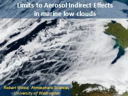
Using Ground Based and in Situ Airborne Observations Collected during the CLARIFY 2017 and LASIC Field Campaigns to Explore Synoptic Dynamical and Aerosol Constraints
Presentation Embed Code
Download Presentation
Download Presentation The PPT/PDF document "Using Ground Based and in Situ Airborne ..." is the property of its rightful owner. Permission is granted to download and print the materials on this website for personal, non-commercial use only, and to display it on your personal computer provided you do not modify the materials and that you retain all copyright notices contained in the materials. By downloading content from our website, you accept the terms of this agreement.
Using Ground Based and in Situ Airborne Observations Collected during the CLARIFY 2017: Transcript
Download Rules Of Document
"Using Ground Based and in Situ Airborne Observations Collected during the CLARIFY 2017"The content belongs to its owner. You may download and print it for personal use, without modification, and keep all copyright notices. By downloading, you agree to these terms.
Related Documents