/
Hurricane Irene August  28, Hurricane Irene August  28,

Hurricane Irene August 28, - PowerPoint Presentation

eve
eve . @eve
Follow
27 views
Uploaded On 2024-02-03

Hurricane Irene August 28, - PPT Presentation

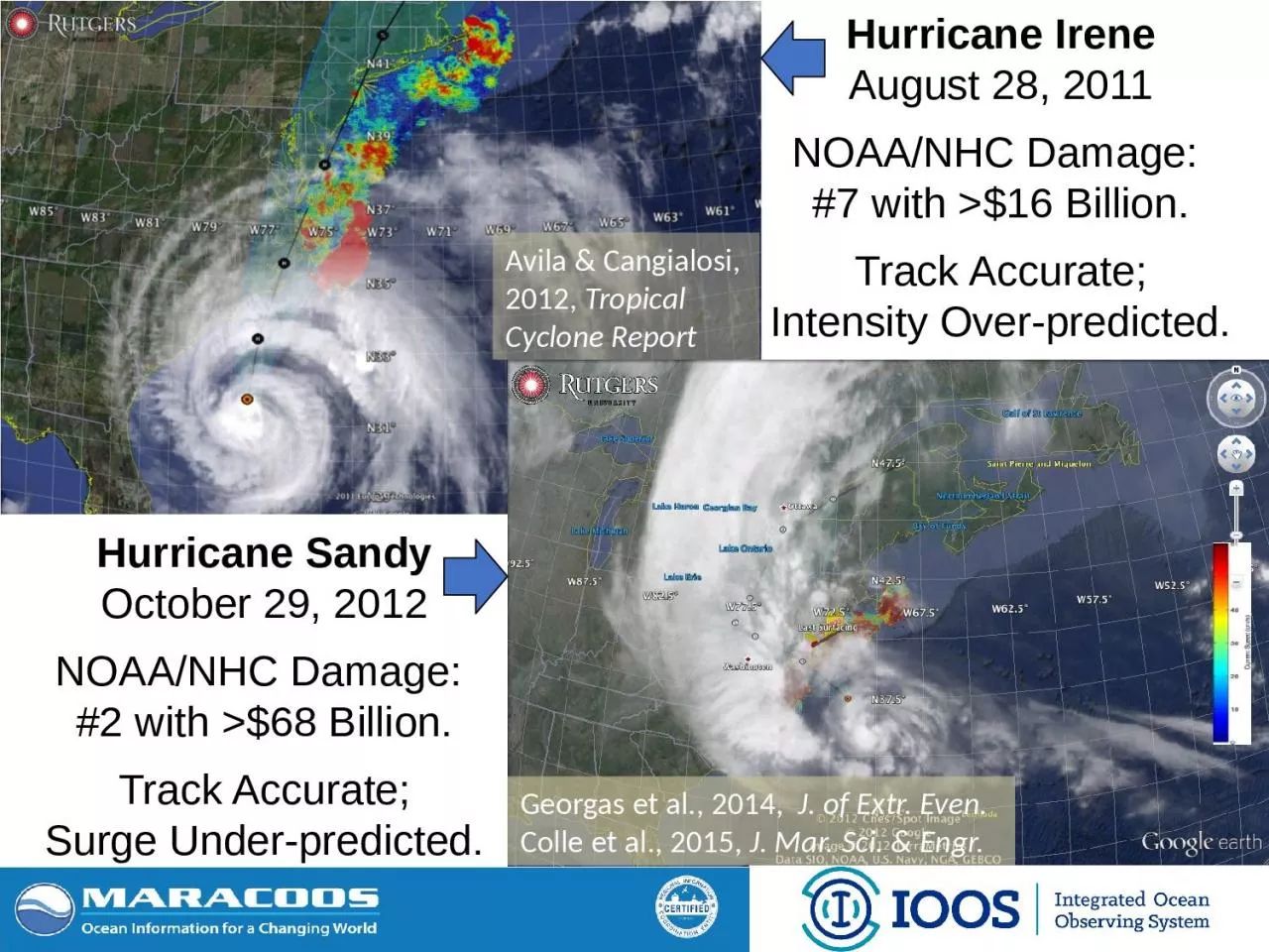
2011 NOAANHC Damage 7 with gt 16 Billion Track Accurate Intensity Overpredicted Hurricane Sandy October 29 2012 NOAANHC Damage 2 with gt 68 Billion Track Accurate ID: 1044263

hurricane cold bottom amp cold hurricane amp bottom ocean glider mid temperature cycle surface cyclone water subsurface profiling navy

Share:

Link:

Embed:

Download Presentation from below link

Download Presentation The PPT/PDF document "Hurricane Irene August 28," is the property of its rightful owner. Permission is granted to download and print the materials on this web site for personal, non-commercial use only, and to display it on your personal computer provided you do not modify the materials and that you retain all copyright notices contained in the materials. By downloading content from our website, you accept the terms of this agreement.


Presentation Transcript

1. Hurricane IreneAugust 28, 2011NOAA/NHC Damage: #7 with >$16 Billion.Track Accurate;Intensity Over-predicted.Hurricane SandyOctober 29, 2012NOAA/NHC Damage: #2 with >$68 Billion.Track Accurate;Surge Under-predicted.Avila & Cangialosi, 2012, Tropical Cyclone Report Georgas et al., 2014, J. of Extr. Even. Colle et al., 2015, J. Mar. Sci. & Engr.

2. Intensity is modulated by the warm or cold ocean.Initial coupling to ocean models was not helping.Steady Improvement

3. Tropical Cyclone Forecasting is a Global Issue for US Navy & NOAAHurricaneDamage measured in DollarsTyphoon & CycloneDamage measured in DeathsGreatest Seasonal Cycle:ChinaKoreaJapanGreatest Seasonal Cycle:Mid-Atlantic Northeast CanadaTropical Cyclone Tracks & IntensitiesSummer – Winter Sea Surface Temperature Difference

4. Mid AtlanticWinter (1-layer)Mid Atlantic Summer (2-layers)Cold PoolWhy unseen? Satellites cannot see below surface, Argo Floats do not extend into shallow waterSummer heating produces a highly stratified ocean - A warm surface layer + An unseen cold bottom layerMid- Atlantic’s Cold PoolYellow Sea’s Cold Bottom Water MassYellow SeaSummerYellow SeaSummerCold Bottom Water MassCold Bottom Water Mass

5. MARACOOS is Certified to Operate New Observing Technologies for US GovernmentCODAR HF Radar for Current MappingSlocum Underwater Glider for Sustained Subsurface Profiling ofTemperature, Salinity, Currents, …. Glider Communicating at SurfaceGlider Profiling Subsurface

6. Operations to Research (O2R) DemonstratedIntegratedOcean Observatoryidentifies processes responsible for rapid ahead-of-eye cooling.Atmosphericmodel sensitivities identify ahead-of-eye cooling as the missing process for rapid de-intensificationNOAA OAR

7. R2O - Hurricane Hermine Response - Glider Fleet Launched, 9/2016GliderHYCOMRTOFS

8. R2O - Navy Global HYCOM: Temperature Below Summer Thermocline Operational GOFS 3.0OpTest of GOFS 3.1Sigma/Z-levels on ShelfNo Cold PoolWell DefinedCold PoolIsopycnal Layers on Shelf

9.

10. What is needed?Oceanographers on the WRFIA hurricane team preparing the plan due April 2018Sentinel Storm Gliders deployed as picket lines reporting subsurface ocean temperature profiles during hurricane seasonStorm Glider Data Assimilation O2R2O cycle for the operational prediction models