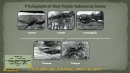
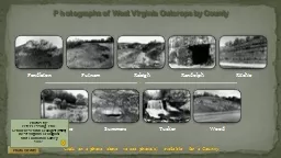
Photographs of West Virginia Outcrops by County Photo Credits Photos by Peter Lessing PhD Senior Research Geologist retired West Virginia Geological and Economic Survey 1997 County ID: 656299
Download Presentation The PPT/PDF document "Click on a photo above to see photo(s) a..." is the property of its rightful owner. Permission is granted to download and print the materials on this web site for personal, non-commercial use only, and to display it on your personal computer provided you do not modify the materials and that you retain all copyright notices contained in the materials. By downloading content from our website, you accept the terms of this agreement.
Slide1
Click on a photo above to see photo(s) available for a County
Photographs of West Virginia Outcrops by County
Photo Credits
Photos by:
Peter Lessing, Ph.D.
Senior Research Geologist (retired)West Virginia Geological and Economic Survey1997Slide2
County: Pendleton
Quadrangle:
Upper TractLocation Info: See comments
Rock Formation(s): Silurian Tuscarora SandstoneStrike/Dip (in degrees)
:
N 30 E, dip is verticalComments: Seneca Rocks from visitors center area (many climbers on the face and at top). The Tuscarora at this location is approximately 200 feet thick with several faults parallel to bedding.Vertical Tuscarora
County List
NextSlide3
County: Pendleton
Quadrangle:
Upper TractLocation Info: Approximately 2 miles northwest of Route 220 on Smoke Hole Road
Rock Formation(s): Devonian Oriskany Sandstone
Strike/Dip
(in degrees): Overturned and now dips 80 SE with Devonian Helderberg on southeast side. Strike is N 20 E.Comments: Also called “Eagle Rocks” and located on Cave Mountain.From Sign at this Location: “Eagle Rocks. Named for William Eagle, a Revolutionary War soldier who lived nearby. Enlisted at age fifteen, 12-24-1776, he served in the 3
rd
, 4
th
, 8
th
, and 12
th, Virginia Regiments, Continental Line, at Valley Forge and Yorktown. Died 1848, and is buried here.” Grave is right behind this sign at Eagle Rocks.
Overturned DevonianOriskany Sandstone
Click on photo above to zoomed view of the fold.
CLOSE
County List
PreviousSlide4
County: Putnam
Quadrangle:
BancroftLocation Info: On Route 34, next to Lone Oak Church
Rock Formation(s): Base of Permian Dunkard Group
Strike/Dip
(in degrees): NoneComments: This is the top of a landslide showing the crown, scarp, and head. The upper scarp is about 15 feet high and the distance across is about 175-200 feet. Slide is mostly red soil of the Dunkard, which is notoriously unstable.Top of Landslide
County ListSlide5
County: Raleigh
Quadrangle:
ArnettLocation Info: 4.2 miles west of Bolt, WV on Route 99.
Rock Formation(s): Pennsylvanian Kanawha FormationStrike/Dip (in degrees)
:
HorizontalComments: Five benches in photo.Coal Strip Mine Benches
County ListSlide6
County: Randolph
Quadrangle:
BowenLocation Info: South side of new Route 33 at Bowden.
Rock Formation(s): Mississippian Greenbrier LimestoneStrike/Dip (in degrees)
:
Nearly horizontal.Comments: Opening to mine is about 30-40 feet high. There is another opening to the same mine at this same location. Route 33 that was built here disrupted springs that fed Bowden fish hatchery and so, this Corridor H was abandoned and ends at Shavers Fork; another screw up by the WV Highway Dept.Abandoned Limestone Mine
County ListSlide7
County: Ritchie
Quadrangle:
SchultzLocation Info: On Route 50, just E of Bear Run Road and 4.5 miles W of Ellenboro
Rock Formation(s): Permian Dunkard (may be Pennsylvanian)
Strike/Dip
(in degrees): HorizontalComments: Entire road cut is about 100 feet high. Thick sandstone near base is about 10 feet thick and green on fresh surface. There are thinner sandstones in middle and upper sections. Interlayered shales are red and green. Note different weathering characteristics.
Sandstone and Shale
Roadcut
County ListSlide8
County: Roane
Quadrangle:
GayLocation Info: On Route 33, 0.5 miles E of Roane/Jackson line and 2.6 miles W of
PenielRock Formation(s): Well is spudded
in Permian
Dunkard GroupStrike/Dip (in degrees): None in photo, but horizontalComments: This oil well is in the Buffalo-Peniel
field (number 162) and oil was obtained from the Salt Sand (Lower Pennsylvanian).
Old Oil Well
County ListSlide9
County: Summers
Quadrangle:
DawsonLocation Info: On I-64 at mile post 147; 0.8 miles west of Summers/Greenbrier County line and 3.5 miles east of Green
Sulphur Springs exit.Rock Formation(s): Mississippian Hinton Formation
Strike/Dip
(in degrees): HorizontalComments: Hammer handle (about one foot long) is parallel to fault that dips 25 E. Displacement unknown. Right side has moved upwards towards upper left of photo.Thrust Fault
County ListSlide10
County: Tucker
Quadrangle:
Blackwater Falls
Location Info: At Blackwater State ParkRock Formation(s):
Pennsylvanian
Conoquesnessing and Homewood SandstonesStrike/Dip (in degrees): HorizontalComments: Several frames from first overlook and from lower walkway. Good photo ops from “Gentle Trail” on other side also. Falls caused by resistant sandstones visible on right.
Blackwater
Falls
County ListSlide11
County: Wood
Quadrangle:
RockportLocation Info: On I-77, 0.7 miles N of Jackson/Wood County line and 0.7 miles N of mile post 157
Rock Formation(s): Permian Dunkard (may be Pennsylvanian)
Strike/Dip
(in degrees): HorizontalComments: Large blocks of rock (the size of cars) with associated red shale have fallen to road level. Red shale here has no strength, and when combined with water, it will slide. Sandstone ledges now have no support, so they too tumble down.Landslide
County List