/
Island Evolution on the Subsiding Central Island Evolution on the Subsiding Central

Island Evolution on the Subsiding Central - PDF document

faustina-dinatale
faustina-dinatale . @faustina-dinatale
Follow
368 views
Uploaded On 2016-08-08

Island Evolution on the Subsiding Central - PPT Presentation

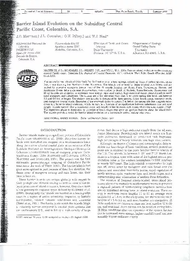
Lder Pacific Coast Colombia SA JO Martinez JL Gonzalez OH Pilkey TUniversidad Nacional de Colombia INGEOMINAS Apartado Aereo 4865 Colombia SA EAFIT Apartado Ae ID: 438991

L~der ?.Pacific Coast Colombia S.A.

Share:

Link:

Embed:

Download Presentation from below link

Download Pdf The PPT/PDF document "Island Evolution on the Subsiding Centra..." is the property of its rightful owner. Permission is granted to download and print the materials on this web site for personal, non-commercial use only, and to display it on your personal computer provided you do not modify the materials and that you retain all copyright notices contained in the materials. By downloading content from our website, you accept the terms of this agreement.


Presentation Transcript

L~der Island Evolution on the Subsiding Central ?.Pacific Coast, Colombia, S.A. J.O. Martinez,? J.L. Gonzalez,$ O.H. Pilkey, $ TUniversidad Nacional de Colombia INGEOMINAS Apartado Aereo 4865 Colombia, S.A. EAFIT Apartado Aereo 3300 and W.J. Neal* $Division of Earth and Ocean Sciences 27708, U.S.A. *Department of Geology Grand Valley State University Allendale, MI 49401, U.S.A. MARTINEZ, J.O.; GONZALEZ, J.L.; PILKEY, the subsiding 16(3), 663-674. West Palm Beach (Florida), ISSN 0749-0208. The remote barrier islands Colombia's Pacific Coast leading edge, (MARTINEZ et al., were identified narrow alluvial Nacional de Investigaci9nes coastal mapping (GoN- ZALEZ and MARIN, MARTINEZ and CARVAJAL, 1990a,b; MARTINEZ and GONZALEZ, project was Colombia's Pacific gone unrecognized and rain and their barrier islands first- the dearth stricts our several general lie between lo 25' and 7" a tropical zone with some �(5000 mmlyear or nearly 200"/year). high rainfall and rain riverldelta plains, rapid 664 Martinez et al. This coast is tide dominated with an average mesotidal range of 3.5 m near Buenaventura, but ranging into spring macrotides of 4.9 m. The maximum island elevation above the line in the study area is only 2.5 m, and most islands are much lower. The general pattern of net longshore transport is from south to north, with pronounced spit elon- gation on the north ends of the islands. The larger inlets between islands appear to be stationary in association with river estuaries. These large estuarine inlets are analogous to the large, deep-throat stable inlets of the Georgia Bight (HAYES, 1994). The larger estuaries commonly have elon- gate sand bars in their channels. Strong ebb currents and river discharge form large ebb-tidal deltas, analogous to OERTEL'S (1977) type D ebb deltas of the U. S. Georgia coast. These deltas are characterized by elongate, shore-perpendicular sand bars that form horn-like extensions bordering the central channel of the ebb delta. Detachment of these shoals allow small, strongly recurved spits to bdd into the inlets on the south ends of all four islands. These local reversals of the regional longshore drift pattern are a function of currents associated with the ebb-tidal deltas. Spit growth may cause temporary narrowing of inlets, 2s but, based on air photos, no sqpdicant inlet migration has oc- - ldlannm curred in the last 40 years. ~id~l creeks and channels dissect the mangrove swamps Figure 1. Index map of the study area from Buenaventura Bay to the mouth of the Rio Naya showing the location of El Soldado, Santa Barbara, behind the islands. Tidal flooding of the troughs behind the Chamuscado, and El Aji Islands. frontal beach ridges sometimes overtops ridges and incises outlets through the frontal ridge. Outlets cuts through a tidal flushing maintains in and out these outlets the troughs and then accretes laterally island front. The growth these frontal islands, although (i.e., they consist of beach and ovenvash facies), and is incorporated origin is not STUDY AREA AND OBJECTIVES I~TINEZ et al. (1995) defined five groups of barrier island chains along Colombia's Pacific coast based on natural geo- morphologic divisions such as individual delta lobes or chains bounded by local upland terraces that form cliffed coasts. The objective is to move from regional reconnaissance to loohng at four selected islands (El Aji, Charnuscado, Santa Barbara, and El Soldado) in greater detail to determine the processes and history island evolution (Figure 1). Through coring, the gen- eral stratigraphy and facies were defined, short-term migra- tion patterns established (e.g., transgressive or regressive), and evidence sought that might indicate subsidence, and signature or cyclic events such as sediment liquefaction due to earth- quakes, tsunami deposits, or repetitive El Niiio events. The northern half of island group 3 (MARTINEZ et al., 1995) was chosen as a representative set of islands (Figure 1). These exist at the edge of a coalesced fluvial-deltaic plain of several large rivers, and provide the least diff?culty in access and logistics (the islands are accessible only by boat). The reach of the islands examined extends for over 80 km from the Rio Naya on the south to Bahia de Buenaventura includ- ing the mouths of the Rio Yurumangui, head in rivers. A chain six islands upland cut an outlier mudstone Formation. The and Chamuscado a chain islands front located in a slight north shore embayment and the marked change deltaic lowlands shore suggests activity traces through upland into suggesting uplift, delta front islands and mangrove swamps cut Island is chain and front. El Soldado offset from information exists nearshore, continental tidal deltas, fluvial sediment loads. benchmarks such fixed survey points, and topographic maps islands to identlfy tablish maximum island elevations, cores, were referenced to high tide mark as seen in the field (e.g., line, or spring tide line). photo coverage variable quality available for approlrimately the 40 years. Journal of Coastal Research, VO~. 16, No. 3, 2000 Barrier Islands in South America 665 showing lines topographic profiling Soldado, Santa Barbara, Chamuscado, and El Aji. 600 SPRING TIDE LINE 4001- -i -- --a ---- PROFILE-C taking push 10 (Figure 2), and five cross-island trenches to depths of 2 m. 200 300 m PROFILE - G Trenches and cores were sampled for textural analysis and reference peels of all cores were made in the field. Eleven cross-island topographic profiles were surveyed to describe features such as beach ridges (Figures 2 and 3). As indicators of age, size of trees was noted, and the absence or presence and thickness of the surface soil profile measured. The larg- est trees aEe approximately a century old, and for these sandy sediments under tropical conditions a soil oxidation depth of 50 to 70 cm can develop in as little as 100 years (Pedro Bot- ero, IGAC, personal communication 1. The rapid change and very young age of significant areas of these islands can be seen in the air photo sequences from 1961 400 to 1992, and is reflected in the core stratigraphy. An anthro- 300 ---- - -, --, - -- - - -- - - pomorphic time horizon is preserved in the ovenvash sedi- PROFILE - j 100 ments because large amounts of refuse and flotsam (e.g., plas- (cm) tic, glass bottles, metal cans) are flushed out of Buenaventura lesser degree Santa Barbara, and buried by washover. t----- ,,, Bay and carried by tides and waves onto El Soldado and to a Figure 3. Representative cross-island topographic profiles for El Soldado (top), Santa Barbara (middle), and El Aji (bottom). The dashed line rep- resents the spring tide line on all three profiles. General Facies The facies presented here are generalized to illustrate the growth trends the islands (Figure 4). facies are represent the lower beach facies. The present beaches are low s~ru~tureless muds with amounts in shell content, but shell concentrates are more common mangrove roots. Overwash deposits are well-sorted sands, along the low-tide line, and scattered in other beach facies. tending be structureless Or bedded and parallel Calcareous shells, however, seem to be removed from the sed- laminated. 1n the trenches, overwash bedding is gently in- iment column in a relatively short time by dissolution. Tidal clined landward with rootlet horizons marhng revegetated flat (mud) and channel facies (gravely sands) occur locally, surfaces buried by the next overwash. The upper beach facies usually near the ends of the present islands. shows more variability including thinly-bedded parallel and highly diagnostic ISLA SOLDADO presently are found accumulating at the back of the beach, Isla Soldado is 5.5 km long and extremely narrow, aver- and along the low tide line of the lower beach. Similar wood aging less than 55 m in width at spring high tide, but three chip layers together with interbedded fine sands that are typ- times that width at low tide (Figure 3). Maximum elevation ically cross laminated to cross bedded, and sometimes shelly. is typically 2 m above the spring high tide line. The island is Journal of Coastal Research, Vol. 16, No. 3, 2000 area the steep slip landward side discern. Both built-up vertically images were not useful migrated into Barbara contrasts sharply forest since Barbara Island, without a slip face or tidal channels). The shallow platform, yet caught up with long-term migration related to sequence is transgressive. The island upper portions ovenvash sections continuous, with line rootlet horizons suggest multi- lacking soil Because ovenvash environment, island submergence is suggested high tide cm-thick mangrove overlies beach facies chip layers, suggests subsidence. events such bed from burial pattern, the sand layers and the mangrove deposits, built up rhythmic small event sediment delta area the north, seaside resorts coast where sea levels level along The ramifications small village (Caserio del 1971 a large village which tidal delta changed (shoal accretion to severe completely removed mangrove forest. Caserio del creek to coming decade. long, 300 a maximum elevation high tide (Fig- a large subaerial sand is difficult is rotational instability. This island and the spit-like feature. The trough ridge is mouth outlet. beach ridge phase when shore migrates into a Troughs may remain open, or with overwash. accumulate layers mangroves. The low-energy microfacies Multiple accretionary events produce troughs and channels in- The result tidal channels linear trend. trellis drainage high tide, trellis drainage typically 10 Their outlets lack significant tidal upper reaches with organic accrete along the island also is Chamuscado and Islands, as other islands chains. These spit-like analogous to those rier islands in the adjacent ebb-tidal the island, where a nodal point Dominant direction aforementioned nodal point is a clear forest behind empty to south, and north). Although long horn-shaped deltas, characteristic tidal inlets impact longshore and intensities. For example, a Barrier Islands in South America 669 1:igurc 7. Comparison sketch maps ofSi1nLi1 13iirbiira Island from aerial photos: 1961-1992. The spil-like features which uccrcte along the front of the island arc not soen at this scale, although the irregularities along hinl of'thcir middle island rcach also is where lhc clr:linagc outlets occur. Note the widening of the northern part of the island. Barbara Inlet acts 9). the front side (Figure 10) vertically and laterally. Thin more extensive and relative mangrove swamp The inner-island stratig- coarsening upward sequences (mangrove mud to overwash) suggests former there has been some logging Barbara, the the early m/yr while accre- half have been m/ yr, rapidly accreting end 7). CHlGMUSCADO ISLAND Chamuscado island km length (Figure 111, el Ajicito Cha- maximum width island is The maximum elevation were approximately bris line. between ridges and interior is subdued because water- dense forest dynamic change in island geometry 1966 and 1992, large island-front 1970 erosion breached rapid land- ward migration mangrove swamp. formed end, a island and a mini-headland from which ridge began to island. Between 1982 and 1992 this feature creating a new ridge and face. Like smaller features outlet mouth the spit continued to accrete to Journal of Coastal Research, Vol. 16, NO. 3, 2000