PDF-MAJESTIC VIEW PARK TRAIL MAP
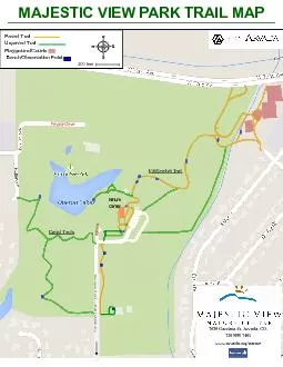
Author : freya | Published Date : 2021-06-29
Private Drive trivate Nature Center Garrison Street Exit to 68th Ave Interpretive Trail Cattail Trails Paved Trail Unpaved Trail PlaygroundCourts BenchObservation
Presentation Embed Code
Download Presentation
Download Presentation The PPT/PDF document "MAJESTIC VIEW PARK TRAIL MAP" is the property of its rightful owner. Permission is granted to download and print the materials on this website for personal, non-commercial use only, and to display it on your personal computer provided you do not modify the materials and that you retain all copyright notices contained in the materials. By downloading content from our website, you accept the terms of this agreement.
MAJESTIC VIEW PARK TRAIL MAP: Transcript
Private Drive trivate Nature Center Garrison Street Exit to 68th Ave Interpretive Trail Cattail Trails Paved Trail Unpaved Trail PlaygroundCourts BenchObservation Point 200 feet 7030 Garri. Park Road 12 Park Road 1 SR 278 To Zaleski State Forest Equestrian Camp Lake Hope Schoolhouse Interpretive Center To Zaleski State Forest Headquarters 4 mi To Logan 25 mi Nelsonville 15 mi To Lake Hope State Park Campground Zaleski Backpack Trail 7033248563 407 Location Map TTY 7038033354 brPage 2br Trail Map wwwfairfaxcountygovparks Funding for Cross County Trail maps has been provided by the Fairfax County Park Foundation wwwfxparksorg DIFFICULT RUN STREAM VALLEY TRAIL is part of the count P a r k R o a d 1100 1180 1380 1320 1420 1480 1100 900 940 940 1280 1300 1400 1420 1560 1520 1500 1640 1620 1600 1580 1540 1440 1320 1340 1180 1200 1220 1240 1440 1460 1480 1400 1420 1560 1380 1520 15 County Council Camping Policies . The camping policies of Mecklenburg County Council reflect those of the National BSA organization. These policies are focused on . 1. assuring the health and safety of all Scouts and their leaders while camping through proper training and trip planning, . 8 8.25 8.5 8.75 9.25 9.5 9.75 2.5 4.25 6.5 1 M 3 6.25 7.25 3.5 5.5 6.75 1.5 0.5 2.25 5.75 7.5 3.25 4.5 4.75 0 0.25 5.25 7.75 2.75 3.75 1.75 http://www.austintexas.gov/department/parks-and-recreation D S Shrubs & TreesReservable Picnic AreaOak Leaf Trail(Paved Multi-Use Trail) Trail SegmentTennisTot LotTrack PARK (7275)UPDATED OCT 17 # 1 6 3 2 5 4 Yard Ravine StageRavine S#1N LAKE PARKWa Field #1Field #2Field #3Field #4 S MONUMENT DRIVEKEMPSVILLE ROADGRANTHAM COURTGETTYSBURG ROADMANASSAS RUN LUDINGTON DRIVE city view park map REV 03/16 Parking Restrooms Park Ofce Public Access A Mission San Juan Capistrano LAKE VERMILIONSOUDAN UNDERGROUND MINE STATE PARK P.O. BOX 335 1379 STUNTZ BAY RD. SOUDAN, MN 55782 LAKEVERMILION-SOUDAN.STATEPARK@STATE.MN.US CURIOUS ABOUT SPECIAL TOURS AT STATE PARKS?VISIT MND -Meeting Minutes June 16 2020Attendance 12attendees Sally Petrella-president Paul Stark-secretary Paula Trilety-membership chairGarrett Dempsey-TrusteeArthur Edge-vice president Jim WestphalDonna Hall wwwtexasstateparksorg Sign up today for free email updates texasstateparksorg/email /texasparksandwildlife TPWDparks TxStateParks Sponsor Whole Earth Provision Co For 3 3 3 336 CFR 22 - WILDLIFE PROTECTION e The following areas are closed to the viewing of wildlife with the use of an artificial light and infrared devices 23 The entire Park is closed to Rd Matt Davis TrailPaci31c OceanMt TamalpaisTo East Peak of Mt TamMILL VALLEYTrailMuir WoodsTo Hwy 101 GASZen Center-Green Gulch FarmMUIR BEACHSTEEP RAVINESLIDE RANCHoaeTr11111MUIR BEACH OVERLOOKPANT HERONLAKETRAILSTRESTLE TRAILTRESTLE TRAILCAUSEWAYCAUSEWAYMUSKRATTRAILHANSEN NATURE TRAILHANSEN NATURE TRAIL196Butterworth DriveO146Brien RoadVeterans146 Memorial DriveIndian Mounds DriveWilson Avenu
Download Document
Here is the link to download the presentation.
"MAJESTIC VIEW PARK TRAIL MAP"The content belongs to its owner. You may download and print it for personal use, without modification, and keep all copyright notices. By downloading, you agree to these terms.
Related Documents