/
Surveying II Surveying II

Surveying II - PowerPoint Presentation

giovanna-bartolotta
giovanna-bartolotta . @giovanna-bartolotta
Follow
427 views
Uploaded On 2017-05-04

Surveying II - PPT Presentation

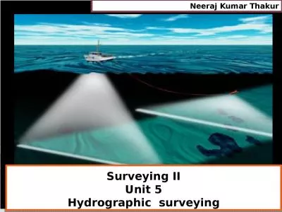
Unit 5 Hydrographic surveying Neeraj Kumar Thakur Introduction shore line survey soundings methods gauges Equipment required for hydrographic surveying sounding ID: 544547

water sounding tide level sounding water level tide line equipment gauges tides lead angle sextant shore surface depth moon

Share:

Link:

Embed:

Download Presentation from below link

Download Presentation The PPT/PDF document "Surveying II" is the property of its rightful owner. Permission is granted to download and print the materials on this web site for personal, non-commercial use only, and to display it on your personal computer provided you do not modify the materials and that you retain all copyright notices contained in the materials. By downloading content from our website, you accept the terms of this agreement.


Presentation Transcript

Slide1

Surveying II

Unit 5Hydrographic surveying

Neeraj

Kumar ThakurSlide2

Introduction

, shore line survey, soundings methods, gauges,Equipment required for hydrographic surveying

, sounding

partymethods of locating soundingsreduction of soundings and plotting of Soundingsproblems related to hydrographic surveying.

2

SyllabusSlide3

It is the branch of surveying which deals with water bodies e.g. Lake, river etc.

The usual fundamental principles of surveying and levelling are adopted for acquiring data for determination of :Water volumeRate of flowTo determine the shape of the area underlying the water surface etc

.

3Hydrographic surveyingSlide4

4Slide5

To determine the quantities of subaqueous excavations.

Measure areas subjected to scouring or silting in harbours or docksLocate rocks and other objects such as buoys, lights etc to aid safe navigation

To prepare navigation charts exhibiting the depths available for navigation

Control floods, and to plan water supply and storage from rivers.To develop water resources for power, irrigation and recreation5PurposeSlide6

The measurement of depth of water at various points is termed as sounding.

Depth of Sounding is referred to the water level at the time it is made.Thereafter, the soundings are reduced to datum water level, to account for tidal waters which undergo continual change of elevation, with the help of gauges.A number of benchmarks (B.M.) are established at frequent intervals along the shorelines, and gauges are set on them.

6

Some points to noteSlide7

The field work consists of both horizontal as well as vertical control.

The horizontal control is established by traversing or triangulation.For vertical control, the tide gauges are kept in operation continuously since the water level at tha gauge must also be known when soundings are recorded.

7

Some points to noteSlide8

These are periodical variations in the water surface of oceans due to the attraction of celestial bodies.

The principal tide producing agents are the sun and moon, of which moon is more powerful tide producer.Tides produced by unbalanced attracting forces between the moon and earth are known as lunar tide.Tides produced by unbalanced attracting forces between the sun and earth are known as solar tides.

Since the sun and moon act simultaneously, the lunar and solar tides are superimposed.

8TidesSlide9

At new moon, the sun and moon have the same celestial longitude and cross a meridian of earth at the same instant.

The three bodies are in one plane.The high water level of the resulting tide is above the average, whereas the low water level is below the average.The tide is known as spring tide of new moon.Same is the case for full moon.

9

Spring and neap tidesSlide10

10Spring and neap tidesSlide11

In about 7.5 days when the moon is in quadrature, the crest of lunar tide co-

incides with the trough of a solar tide.High water level is below the average, whereas low water level is above the average.Such a tide is known as neap tide of the first quarter/third quarter.

11

Spring and neap tidesSlide12

12Spring and neap tidesSlide13

These are used to determine the exact water surface level.

The movement of tides during the time soundings are made.The gauges are read at regular intervals, varying from 10m to 30 min.13

Tide gauges


h is height of water level at time of sounding

is mean sea level


is time between high tide and

time of sounding


is time between high tide and

low tide


is rise of tide above MSL

 Slide14

These gauges may be

non-registering or self registering types.Non registering types requires an observer to record the water level.Staff gauge.Float gauge

Weight gauge

14Tide gaugesSlide15

15a) Staff gauges

Simplest type of gauge.

It consists of a graduated board, 150 to 250 mm wide and 100 mm thick, fixed in vertical position.Slide16

16Slide17

17b

) Float gauges

The float gauge is designed to overcome the difficulty in reading a staff gauge when the intensity of tides is high and the variations of water level is more.

It consists of a float to which a graduated vertical staff is attached.Slide18

18b

) Float gaugesSlide19

19c) Weight gauges

The weight gauge consists a weight attached to brass chain or wire.

The chain passes over a pulley, and is laid horizontal along the side of a graduated scale.

The weight is lowered to touch the water surface, and the reading is taken on the graduated scale against an index attached to the chain.Slide20

20c) Weight gaugesSlide21

21Self registering gauges

Self registering tide gauges automatically record the variation of water level with time.Slide22

Mean sea level is defined as the main level of the sea obtained by taking the mean of all the heights of tides measured at regular interval of one hour over a stated period (about 19 years) covering entire number of complete tides.

Mean sea level shows appreciable variations from day to day, from month to month and even from year to year.22

Mean Sea LevelSlide23

The process of determining depths below the water surface is called sounding.

Sounding is analogous to levelling on land.The reduced level of any point on the bottom of a water body is obtained by subtracting the sounding from the mean sea level.

23

SoundingSlide24

Preparation of accurate charts for navigation.

Determination of the quantities of the material to be filled.Obtaining information for design of breakwaters, sea wells etc.24

Purpose for soundingSlide25

The sounding points should be selected keeping in mind that all the important irregularities are recorded.

The soundings are thus made along a series of straight lines at right angles to the shoreline.The spacing between the sounding lines and between the sounding points depends upon the nature of submarine surface as well as on the object of the survey.Usually Spacing between sounding lines is kept 30 m and spacing between sounding points is kept 7.5m to 15 m.

25

SoundingSlide26

26

Sounding

Shore line

Range line

Sounding pointSlide27

A range or a range line is the line along which soundings are made.

These are usually fixed perpendicular to the shoreline and are parallel to each other.27

Range lineSlide28

28Range lineSlide29

The essential equipment and instrument employed for taking the sounding may be grouped as :

Shore signals and buoys.Sounding equipment.Angle measuring instruments.29

Equipment for soundingSlide30

Shore signal are required to mark range lines.

Each range line is marked with two signals, at some distance apart, along it on each shore.The signals are usually wooden tripods with a white and coloured flag on the top.

A buoy is a float made of light wood or hollow air tight vessel properly weighted at the bottom, and is anchored in a vertical position by means of wires.

In deep waters, the range lines are marked by a signal at shore and buoys in water.301. Shore Signal and buoysSlide31

31

1. Shore Signal and buoysSlide32

1. Sounding boat :

The sounding operation is carried out from a flat bottom boat of low draft.The boats are generally provided with opening, called wells through which soundings are taken.The motor should have adequate control both for low speed and for rough waters32

2. Sounding EquipmentSlide33

33

Sounding boatSlide34

2. Sounding Pole or rod

These are made of strong well seasoned timber usually 5 to 10 cm in diameter and 5 to 8 m in length.The sounding rods consists of two or three lengths screwed together so that unnecessary length may be removed when not required in shallow water.A lead shoe of sufficient weight is fitted at the bottom to keep the rod vertical in flowing water, and to avoid sinking in mud or sand.The graduations on the rod are marked from bottom upwards.

Thus, the reading corresponding to the water surface, is directly the depth of water.

342. Sounding EquipmentSlide35

3. Lead line

It consists of a graduated line or chain to which a lead is attached.Under ordinary tension, when wet, the line should not change its length.Every one feet of the lead is marked with a cloth.The mass of the lead is generally between 5 to 10 kg, depending upon the strength of current and depth of water.

A correction is required to be applied to the measured length to get the true depth when using lead line.

Due to drag, the measured length will be greater than the true depth.352. Sounding EquipmentSlide36

36

Sounding boat / Sounding pole/ lead lineSlide37

4. Weddell’s Sounding machine

When there is a lot of sounding work, some form of sounding machine attached to sounding line is used.Weddell’s hand driven machine consists of a cast iron casing carrying on a spindle gun metal barrel.A lead weight (8kg) carried at the end of a flexible wire cord attached to the barrel, can be lowered at a desirable rate, the speed of the drum being controlled by a brake.The spindle is connected through gears to two reading dials.

37

2. Sounding EquipmentSlide38

The outer dial records the depth in meters and the inner records in centimeters.

A standard machine designed to measure maximum depths up to 30m to 40m.382. Sounding EquipmentSlide39

39

Weddell’s Sounding machine.Slide40

5. Echo sounding machine / Fathometer

Where the depth of water is too much, an echo sounding machine known as fathometer is used.It measures the depth below the boat on which it is installed.It works on the property echo property.It consists of a transmitter and a receiving oscillator, recorder unit and a power unit.

The sound waves emitted at the surface of the water are recorded back after these return from the underwater surface.

402. Sounding EquipmentSlide41

5. Echo sounding machine / Fathometer

Since the velocity of sound waves in water is known, the distance travelled by sound waves can be calculated.D = ½ V tThis method is very accurate and can be used in strong winds.It is more sensitive than other methods, and produces continuous record in the form of curves when boat is in motion

41

2. Sounding EquipmentSlide42

5. Echo sounding machine / Fathometer

Advantages of Fathometer :It is more accurate than the lead line.It can be used in strong currents or streams.It is more sensitive than the lead line method.

It can be used on days, or in any weather, when the ordinary lead line method would be impossible.

It is much more rapid in use than the ordinary method422. Sounding EquipmentSlide43

43

Fathometer / Echo sounding methodSlide44

Most common angle measuring instruments are :

TheodolitePrismatic compassSextant.

The theodolite and prismatic compass are not suitable for angle measurements from sounding boats due to instability of rowing boats.

Sextant has been found to be most suitable for measuring angle in any plane.443. Angle measuring EquipmentSlide45

45

3. Angle measuring EquipmentSlide46

Navigators and surveyors measure angles from sounding boat by sextant only.

When observations are made from the shore, theodolite and prismatic compass are used.The sextant used in hydrographic surveying is known as the sounding sextant.It slightly differs in construction from the astronomical sextant.46

3. Angle measuring EquipmentSlide47

Points to be kept in mind while using sextant :

Angle measured with a sextant is an oblique unless three points sighted lie in horizontal plane.The size of the angles and length of sights affect the precision of angle measurement.A sextant is not recommended for angle measurements when the angles are less than 15 degrees and the sights are less than 300 m.

Vertical angles can also be measured with a sextant in a similar manner to that of horizontal angles.

473. Angle measuring Equipment