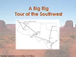
Tour of the Southwest PowerPoint presentation by Mrs LeFave amp Mrs Daniels Southwest Region Tour Stop 1 Monument Valley Home of the Navajos Stop 2 Phoenix Arizona Americas Hottest City ID: 391193
Download Presentation The PPT/PDF document "A Big Rig" is the property of its rightful owner. Permission is granted to download and print the materials on this web site for personal, non-commercial use only, and to display it on your personal computer provided you do not modify the materials and that you retain all copyright notices contained in the materials. By downloading content from our website, you accept the terms of this agreement.
Slide1
A Big Rig Tour of the Southwest
PowerPoint presentation by Mrs. LeFave & Mrs. DanielsSlide2
Southwest Region TourStop 1: Monument Valley: Home of the NavajosStop 2: Phoenix, Arizona: America’s Hottest CityStop 3: Hoover Dam: A Concrete MarvelStop 4: The Grand Canyon: Arizona’s World-Famous Wonder
Stop 5: Carlsbad Caverns: Big Rooms and Bats in New MexicoStop 6: El Paso & Ciudad Juarez: Two Cities, Two Countries, One Border
Stop 7: San Antonio, Texas: Home of the Alamo
Stop 8: Austin: The Capital of Texas
Stop 9: Guthrie, Oklahoma: Center of the Land RushSlide3
Traveling by Big Rig
Essential Question
How have geography
and history shaped life in the Southwest?
During our tour of the Southwest Region, we will travel in big rigs (large trucks also known as
mack
trucks or 18-wheelers). Big rigs drive all over the country bringing goods from one place to another.Slide4
Welcome to Arizona!State Date: February 14, 1912Nickname: Grand Canyon StateMotto: God Enriches
Capital: PhoenixFlower:
Blossom of the Saguaro Cactus
Bird:
Cactus Wren
Tree:
Palo Verde
Song:
ArizonaSlide5
The first stop we will travel to is Monument Valley…Slide6
Stop 1: Monument Valley: Home of the NavajosMonument Valley is within the Navajo Nation Reservation, the largest reservation in the country. Many places in Monument Valley can only be reached on tours led by Navajo guides. The monuments have descriptive names such as Rain God Mesa, Elephant Butte, and Totem Pole.
Fun Fact:
A
butte
is taller than it is wide. A
mesa
is wider than it is tall.Slide7
Stop 1: Monument Valley: Home of the NavajosMonument Valley tour video (2:04)Slide8
Stop 1: Monument Valley: Home of the NavajosThe traditional Navajo home is called a hogan. They are usually round, cone-shaped, and made of wood and packed mud. There is a hole in the top so that smoke can get out. The door of a hogan
faces east to welcome the rising sun and for good luck.Slide9
Stop 1: Monument Valley: Home of the NavajosMonument Valley from sunrise to moonrise video (4:27)Slide10
Four CornersMonument Valley is located near the Four Corners area. The Four Corners is the spot where the borders of Utah, Colorado, Arizona, and New Mexico meet. The spot was first marked in 1912, and a bronze marker was placed in 1931.Slide11
Activity: Make a NavajoDream CatcherInstructions:
Tie one end of a piece of yarn 5-6 feet long to any one of the holes on the rim of the paper plate. Weave the yarn up, over, and all around the paper plate from one hole to the next one. You can make your pattern any way you like. Make sure to loop through each of the punched holes.
You can add the craft beads to the middle of the dream catcher with the yarn as you go through the holes. Simply slip them onto the yarn and continue with the next hole. They will appear to be in the middle of the dream catcher.
Once all of the holes are threaded with the yarn, tie a knot at the end of the yarn with the plate and the last hole.
Take 3 pieces of yarn about 5 inches long each and tie them to the 3 punched holes at the bottom of the dream catcher.
Choose some beads to thread onto each of the 3 yarn pieces and then tie one feather to the end each of the hanging yarn pieces.
Tie a piece of yarn to the hole at the top of your paper plate dream catcher.Slide12
The next stop we will travel to is Phoenix, Arizona…Slide13
Stop 2: Phoenix, Arizona: America’s Hottest CityPhoenix was founded by Jack Swilling, a veteran of the American Civil War, in 1867. He built canals that followed those of an ancient Native American irrigation system. It is the hottest large city in the country, and the largest state capital in the United States.
The Central Arizona Project (CAP) system of aqueducts also follows the older canals, and is the largest and most expensive aqueduct system ever built in the United States. The 336 miles of aqueducts, tunnels, pumping plants, and pipelines were begun in 1973 and are still not completely finished. Slide14
Stop 2: Phoenix, Arizona: America’s Hottest CityCentral Arizona Project (CAP) video (1:51)Slide15
The next stop we will travel to is Hoover Dam…Slide16
Stop 3: Hoover Dam: A Concrete MarvelThe Hoover Dam was built between 1931 and 1935 during the Great Depression. The dam is used to control flooding, store water, and produce
hydroelectric power. The electricity it generates provide power to Arizona, Nevada, and California.
Fun Fact:
Lake Mead is the largest reservoir in the country and has enough
water to flood the whole state of New York with 1 foot of water.Slide17
Stop 3: Hoover Dam: A Concrete MarvelHoover Dam construction video (2:00)Slide18
Stop 3: Hoover Dam: A Concrete Marvel
Fun Facts:
Every state provided
supplies or materials for the construction of the dam.
There is enough concrete in the dam to build a 4 foot wide sidewalk around the Earth at the Equator.
Inside Hoover Dam video (5:47)Slide19
The next stop we will travel to is The Grand Canyon, Arizona…Slide20
Stop 4: The Grand Canyon:
Arizona’s World-Famous Wonder
The Grand Canyon was carved out over millions of years by water
eroding
the rock to form a
canyon
.
Grand Canyon formation video (3:51)
Fun Fact:
The Grand Canyon
Skywalk is 4000 feet above the bottom of the canyon.Slide21
Stop 4: The Grand Canyon: Arizona’s World-Famous WonderGrand Canyon Tusayan Ruin video (1:47)
The Ancient Pueblo People were the first to live in the Grand Canyon area. They lived at the
Tusayan
Pueblo in the Grand Canyon about 800 years ago. The Hopi tribe is descended from the Ancient
Puebloans
.Slide22
Stop 4: The Grand Canyon: Arizona’s World-Famous WonderGrand Canyon fly-through video (3:02)Slide23
Copper Mining in ArizonaEarly in its history, Arizona’s economy relied on the five C’s
– copper, cotton, cattle, citrus, and climate (tourism). Today, the state is the top producer of copper in the United States, mining two-thirds of the copper produced in the country. One of the state’s nicknames is The Copper State
.
From 1793 to 1857, a penny was made of all copper. Today, pennies are less than 1% copper on the inside with a thin layer of pure (100%) copper on the outside.
Fun Fact:
It costs almost 2 and a half cents to make a penny.
Copper mining in Bisbee, AZ in the early 1900sSlide24
Welcome to New Mexico!State Date: January 6, 1912Nickname: Land of EnchantmentMotto: It grows as it goes.
Capital: Santa FeFlower:
Yucca
Bird:
Roadrunner
Tree:
Piñon
Song:
O, Fair New MexicoSlide25
The next stop we will travel to is Carlsbad Caverns, New Mexico…Slide26
Stop 5: Carlsbad Caverns: Big Rooms and Bats in New MexicoThe first extensive exploration of the caverns was by cowboy and cave explorer Jim White. He first entered the caves in 1898 when he was only 16 years old. From 1926 to 1929, he was the Chief Ranger of Carlsbad Cave National Monument.Slide27
Stop 5: Carlsbad Caverns: Big Rooms and Bats in New MexicoCarlsbad Caverns National Park has over 117 caves, but only a few of them are open to the public. You can enter Carlsbad Caverns through the natural entrance or by an elevator from the visitor center.
Fun Fact:
Stalactites
hang on
tight
to the ceiling.
Stalagmites
might
reach the ceiling some day.Slide28
Stop 5: Carlsbad Caverns: Big Rooms and Bats in New MexicoCarlsbad Caverns part 1 (Big Room) video (4:12)Carlsbad Caverns part 2 (King’s Palace) video (4:35)Slide29
Stop 5: Carlsbad Caverns: Big Rooms and Bats in New Mexico
There are 17 species of bats that live in the caves. In the summer, there are hundreds
of thousands of
Mexican free-tailed bats.
Carlsbad Caverns bat video (1:36)Slide30
Welcome to Texas!State Date: December 29, 1845Nickname: Lone Star StateMotto: Friendship
Capital: AustinFlower:
Bluebonnet
Bird:
Mockingbird
Tree:
Pecan
Song:
Texas, Our TexasSlide31
The next stop we will travel to is El Paso & Ciudad Juarez…Slide32
Stop 6: El Paso & Ciudad Juárez: 2 Cities, 2 Countries, 1 Border
The cities of El Paso and Ciudad Juárez are on opposite sides of the United States – Mexico
border
, the line that separates the two countries. American companies have built factories, called
maquiladoras
, in Ciudad
Juárez
because people in Mexico will work for less money than those in the United States. The products they make are driven back over the border in big rig trucks. Slide33
The next stop we will travel to is San Antonio, Texas…Slide34
Stop 7: San Antonio, Texas: Home of the AlamoTexas used to be part of Mexico, and the people that lived there were called Texians or Texicans. In 1836, Texians at the Alamo fought a battle during a
rebellion against the Mexican government. Even though they lost that battle, the Texians did win the rebellion during the Battle of Jacinto later that year, and Texas became a country for nine years. In 1845, Texas joined the United States and became the 28
th
state.
Battle of the Alamo video (2:47)Slide35
The next stop we will travel to is Austin, Texas…Slide36
Stop 8: Austin: The Capital of Texas
The city of Austin is the state capital of Texas. Have you ever heard the saying “
everything is bigger in Texas
”? The capital building in Austin is the biggest one of any state in the country! Texas is not the biggest state though, it is the second biggest. Alaska is more than twice as large.
Just like the national capital makes laws for all of the United States, a state capital makes laws and decisions for the people in a state.
Downtown Austin tour video (2:21)Slide37
Austin’s Bats
During the summer, hundreds of thousands of migratory Mexican free-tailed bats live under the Congress Avenue Bridge in Austin. It is the world’s largest urban bat colony, and there are so many bats that they outnumber the human population of Austin. The bats hang beneath the bridge’s road deck in gaps in the concrete. Every night the bats emerge from under the bridge to eat bugs.
Austin bat video (1:38)Slide38
Welcome to Oklahoma!State Date: November 16, 1907Nickname: Sooner StateMotto: Labor conquers all things.
Capital: Oklahoma CityFlower:
Mistletoe
Bird:
Scissor-tailed Flycatcher
Tree:
Redbud
Song:
Oklahoma!Slide39
The last stop we will travel to is Guthrie, Oklahoma…Slide40
Trail of TearsDuring the1830s, the United States government made what is now Oklahoma an Indian Territory and forced many Native Americans to walk thousands of miles from their homelands to live in Oklahoma. Many of them died along the way and the journey is known as the Trail of Tears. The Indians were relocated so that white people could settle in the southeast.Slide41
Stop 9: Guthrie, Oklahoma: Center of the Land RushIn 1889, the government decided that people besides Native Americans should also be able to settle in Oklahoma. They arranged a one day land rush beginning at noon on April 22, and about 50,000 settlers, mostly white, were able to claim free land (up to 160 acres) in Oklahoma.
Land Rush video (3:32)
According to the May 18, 1889 edition of
Harper’s Weekly
:
“
At twelve o'clock on Monday, April 22d, the resident population of Guthrie was nothing; before sundown it was at least ten thousand. In that time streets had been laid out, town lots staked off, and steps taken toward the formation of a municipal government.
"Slide42
Activity Introduction: Land Rush RecreationYou will each get a Land Rush Role Card. Read your role carefully, it will be important throughout the activity.American IndianBoomer, Rancher, or Railroad Worker
SoonerLand Rush Participant
Line up around the outside of the space that is representing Oklahoma.Slide43
Activity Phase 1: Land Rush RecreationIn Phase 1 (1830s), American Indians are forced to move into Oklahoma. Cherokees were forced to march more than 1000 miles to settle in Indian Territory. Many died along the way and the journey became known as the Trail of Tears.
If you have an American Indian role card, move into Oklahoma now.
Question 1
How do you feel about being moved to a new home?
Question 2
How do you feel about having your own area, far away from white settlers?Slide44
Activity Phase 2: Land Rush RecreationIn Phase 2 (1870s and 1880s), states near Oklahoma had many white settlers. Boomers moved into Indian Territory, but most were forced to leave. Ranchers
drove their cattle through Oklahoma and put up fences. In 1887 the railroad across Oklahoma was completed and Railroad Workers moved into the state.
If you have a
Boomer, Rancher, or Railroad Worker
role card, move into Oklahoma now.
Question 1
Why have you decided to move into Indian Territory?
Question 2
How will you deal with American Indians, since they own this land?Slide45
Activity Phase 3: Land Rush RecreationIn Phase 3 and 4 (1889), the government bought some of the American Indian lands and scheduled a race for white settlers to claim land.Sooners were people who sneaked in before they were supposed to. They wanted to get the best land before the race even started.
If you have a Sooner role card, move into Oklahoma now. A Fate Card lying face down on the floor will tell you what happens to you in Oklahoma.
Questions for American Indians, Boomers, Ranchers, and Railroad Workers
What do you think of the land rush?
How do you think it might change your lives?Slide46
Activity Phase 4: Land Rush RecreationLand Rush Participants waited for the start signal of the race to claim land.If you have a Land Rush Participants
role card, move into Oklahoma now. A Fate Card lying face down on the floor will tell you what happens to you in Oklahoma. Interview classmates with each of the roles to complete your handout. How was the experience different for
American Indians
,
Boomers
,
Ranchers
,
Railroad Workers
,
Sooners, and Land Rush Participants?Questions for all roles
How did you feel during this activity?
What was your experience of settling in Oklahoma?
Do you think there was a better way to decide who got land in Oklahoma?