/
hile “Burnt” is a suitable name for this peak, it could just hile “Burnt” is a suitable name for this peak, it could just

hile “Burnt” is a suitable name for this peak, it could just - PDF document

karlyn-bohler
karlyn-bohler . @karlyn-bohler
Follow
386 views
Uploaded On 2016-05-05

hile “Burnt” is a suitable name for this peak, it could just - PPT Presentation

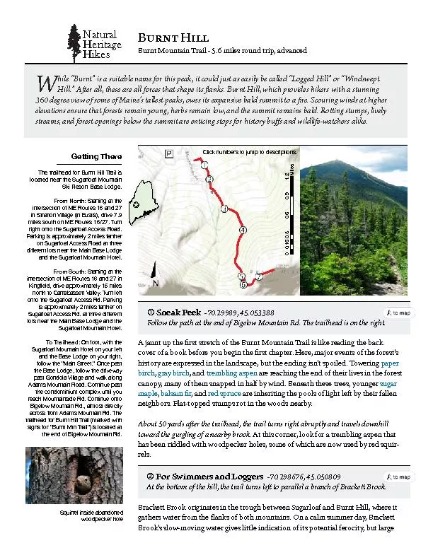
0 03 06 09 12 015 Miles Sneak Peek Follow the path at the end of Bigelow Mountain Rd e trailhead is on the right NaturalHeritageHikes 0060Squirrel inside abandoned rocks in the streambed tel ID: 306570

0 0.3 0.6 0.9 1.2 0.15 Miles Sneak Peek Follow the

Share:

Link:

Embed:

Download Presentation from below link

Download Pdf The PPT/PDF document "hile “Burnt” is a suitable nam..." is the property of its rightful owner. Permission is granted to download and print the materials on this web site for personal, non-commercial use only, and to display it on your personal computer provided you do not modify the materials and that you retain all copyright notices contained in the materials. By downloading content from our website, you accept the terms of this agreement.


Presentation Transcript

0 0.3 0.6 0.9 1.2 0.15 Miles hile “Burnt” is a suitable name for this peak, it could just as easily be called “Logged Hill” or “Windswept Hill.” Aer all, these are all forces that shape its anks. Burnt Hill, which provides hikers with a stunning 360 degree view of some of Maine’s tallest peaks, owes its expansive bald summit to a re. Scouring winds at higher elevations ensure that forests remain young, herbs remain low, and the summit remains bald. Roing stumps, lively streams, and forest openings below the summit are enticing stops for history bus and wildlife-watchers alike.Mkttotm TnkrkTnk trgornkgj lur Hurtt orr Trgor oy Lrus Turtn:ot Strgttut Vorrgmk .ot Euytoy), jrovk 7.9 sorky yuutn ut SE Ruutky 16/27. Turt Pgrkotm oy gvvruxosgtkry 2 sorky lgrtnkr ut Sumgrrugl Giikyy Rugj gt tnrkk jollkrktt ruty tkgr tnk Sgot Hgyk Rujmk Lrus Suutn:Kotm�krj, jrovk gvvruxosgtkry 15 sorky turtn tu Igrrghgyyktt Vgrrky. Turt rklt oy gvvruxosgtkry 2 sorky lgrtnkr ut Sumgrrugl Giikyy Rj. gt tnrkk jollkrktt Tu Trgornkgj:lurruw tnk “Sgot Strkkt.” Utik vgyt vgyt Mutjurg Vorrgmk gtj wgrk grutm rkgin Suuttgotyojk Rj. Iuttotuk uttu Homkruw Suuttgot Rj., grsuyt jorkitry giruyy lrus Gjgsy Suuttgot Rj. Tnk trgornkgj lur Hurtt orr Trgor .sgrkkj wotn yomty lur “Hurtt Stt Trgor”) oy ruigtkj gt A jaunt up the rst stretch of the Burnt Mountain Trail is like reading the back cover of a book before you begin the rst chapter. Here, major events of the forest’s Sneak Peek Follow the path at the end of Bigelow Mountain Rd. e trailhead is on the right. NaturalHeritageHikes 0060Swuorrkr otyojk ghgtjutkj rocks in the streambed tell a dierent story. During spring snowmelt or aer a big rainstorm, Bracke Brook tears through this ravine carrying large cobbles and boulders.e incredible force of water here wasn’t lost on the innovative New England loggers of the 1800’s and early 1900’s. During high water, typically spring runo, loggers used large creeks and rivers to transport logs downstream to lumber mills. Because of the convenience oered by owing water, shallow slopes near waterways were heavily logged. While Bracke Brook is not powerful enough to transport logs, the south branch of the Carrabasse River is. Bracke Brook ows into the Carrabasse River, which joins the Kennebec River in Anson. e water in Bracke Brook will eventually pass Augusta and enter the ocean northeast of Portland.In 1840, the closest sawmill to Burnt Hill was likely in Kingeld, approximately 10 miles southeast of where you now stand. By contrast, there were at least 21 sawmills where the Kennebec River enters the ocean. As your route follows the stream, watch for at-topped stumps, evidence of this area’s logging history. At 0.25 miles, the trail splits inconspicuously and one section makes a short detour to cross Bracke Brook to the right. On days when the water is calm, this pool is an excellent swimming hole. Within 25 yards, the trail will cross back again.Pioneer Trees At 0.7 miles, the trail crosses the second of two logging roads and gradually parts ways with Bracke Brook.e largest and most numerous trees on the lower slope of Burnt Hill, paper bircare the rst clue that this forest burned. Like the bigtoothed aspe and quaking aspethat are also found here, paper birch is known for its ability to colonize a forest aer a large disturbance, such as a re. Its small, light seeds easily travel long distances in the wind to reach new sites, but they do not contain enough stored nutrients for their roots to grow through leaf lier, or for their shoots to survive in shade. is pioneer species is most successful when its seeds land on the bare soil that is oen le aer a large re.Like many pioneer species, paper birch is shade-intolerant. Aer paper birches have grown tall enough to generate shade and leaf lier, trees more tolerant of shade begin to colonize the understor. By the time the paper birch has reached the end of its life, the sugar maple and balsam r present in the understory will dominate the canopPaper birch will disappear from the forest as it matures. e second clue le behind by the 1908 forest re is glossy bits of charcoal in the soil. ough they have been concealed by more than a century’s worth of leaf lier and new soil, you can nd these re remnants on the trail where hikers before you have erode away layers of soil. is re burned approximately 5,500 acres, including the north side of Sugarloaf. It is partially responsible for Sugarloaf’s famous skiing above treeline. Pgvkr horin hgrk krk, yuutm ytrovkj sgvrk, hgrygs �r, gtj yumgr sgvrk hkmot tu irkkv ykywgrj, ynkrtkrotm gt nkrh rgykr ul hruk-hkgj rory, worj ygrygvgrorrg, Igtgjg sgy�uwkr, gtj wuuj yurrkr. Tnoy lurkyt oy trgtyotoutotm lrus gt Egrry Suiikyyoutgr Lurkyt tu g Svruik - Turtnkrt grjwuujy Lurkyt. Naturalist’s Notes Naturalist’s NotesGlades in Summer At 1 mile, the trail turns southwest and levels slightly as it begins wrapping around Burnt Hill. Here, hikers pass two swaths of clear cut forest doed with birch.In green, leafy summertime, it’s hard to imagine these forest clearings or glades as having smooth, white, snow-covered ski trails – and skiers. But that’s what happens here in winter. In summer, these quiet glades with their shrubby thickets, tall ferns, and grasses are prime real estate for both animals and wildlife watchers.Where the mature forest meets the shrubby gap, species that depend on both habitats congregate. For example, red bats roost in dense hardwood forests, but hunt for insects in clearings by night. Yellow warbler and ommon yellowthroa inhabit early-successional shrublands, where they attract birds of prey and egg-eating animals like raccoons. Plant-eating (herbivorous) mammals like snowshoe hares and mice congregate in thick brush, attracting coyote, lynx, and other predators. Even moose and deer will occasionally wander through these glades.e Power of Wind As the trail steepens dramatically at 1.7 miles, the forest grades into Subalpine FiNear the top of the hill, the canopy is a mosaic of dense red sprucbalsam fi, and paler heart-leaved birch, interspersed with sunny openings. Young balsam fir and mountain holly shrubs thrive in the sunny patches, with lower-growing blue-bead lily, bunchberry, mountain wood fern, big-leaved aster, and starflower growing where there is the most light.While historic fire and natural succession have been the primary forces shaping the forest downslope, wind has sculpted much of the plant growth on the upper slopes and summit of Burnt Hill, resulting in a Subalpine Fir Forest. In this forest type, trees can’t grow very large because as soon as they break rank with their neighbors, they are toppled or snapped in half by wind. Because older trees are constantly falling, the forest is perpetually riddled with gaps that are rapidly filled by new growth of fir.Continuing up the trail, the forest transforms into a brighter variation of Subalpine Fir consisting of almost entirely paper birch and large, multi-trunked mountain ash. This is an area of subalpine fir forest that has burned. Balsam fir lingers in the understory, and will eventually fill in as the paper birch dies off. A brook is audible nearby.Within 100 yards, the trail plunges back into the darker forest and continues steeply uphill.Clinging for Life e trail reaches the relatively at shoulder of Burnt Hill at 2.1 miles.Here in the Spruce - Fir Krummholt, wind baered black spruc and balsam r don’t stand much taller than you. Krummholz is the gatekeeper of true alpin communities. Exposed to constant baering winds and growing in thin soils, the trees are shaped a bit like ags, with higher branches growing on the downwind side of the trunk. Blueberries, Labrador tea, mountain holly, and sheep laurel are sheltered between trees or rory, gtj hutinhkrry hgykotm ot grjkr, sgvrk-rkgvkj vohurtus, gtj hrgikkt lkrt. Hrgkkt lkrt Worj ygrygvgrorrg tucked into rock crevices. On a calm day in early summer, this is a good place to listen for hite-throated sparrowedar waxwing, and the rare Bicknell’s thrusWelcome to the Alpine Zone By mile 2.4, most of the trees have fallen into the distance.You’ve reached the alpine zone. Here, blue blazes alternate with rock cairns to mark the trail. Vegetation and soil here are fragile and easily damaged, so it is important that hikers follow these marks.Fire and wind are both responsible for Burnt Hill’s bald summit; re cleared the peak of vegetation, and since then wind has made it very dicult for soil to accumulate or trees to survive. In the thin soil between the rocks, highland rush, three-leaved cinquefoil, and alpine bilberry are prominent. is is a Mid-elevation Bal, a rare community found on exposed bedrock summits or upper mountain slopes at moderate to high elevations.e summit of Burnt Hill oers a spectacular 360-degree view toward surrounding mountains. You are in the presence of some Maine giants. e striped ank of Sugarloaf, Maine’s second tallest mountain, is almost due west; the multi-peaked Bigelow Range is due north; Lile Poplar Mountain is to the northeast and Owl’s Head is close and to the southeast. Alpine: Above the treeline.Canopy: e highest layer of vegetation in the forest; usually the tops of trees.Erosion: e process by which soil and rock is transported deposited in other locations.Understory: e layer of vegetation that grows between the ground and the highest layer of tree branches in a forest.Naturalist’s GlossaryNatural Heritage Hikes is a project of the Maine Natural Areas Progra in partnership with the Maine Trail Finder website.For more Natural Heritage Hikes, please visit www.mainetrailnder.coDesigned and wrien by Kelly Finan, University of Vermont Field Naturalist ProgramMap sources: Esri, DeLorme, HERE, TomTom, Intermap, increment P Corp., GEBCO, USGS, FAO, NPS, NRCAN, GeoBase, IGN,Kadaster NL, Ordnance Survey, Esri Japan, METI, Esri China (Hong Kong), swisstopo, and the GIS User Community Naturalist’s NotesTnk tkrs krussnurz iusky lrus tnk Mkrsgt “kruss” .iruukkj), gtj “nurz” .wuuj). Hkiguyk trkky ruyk g hrgtin, tnkyk trkky ngvk gjuvtkj g ruw, twoytkj mruwtn wotj gtj ytuw. tucked into rock crevices. On a calm day in early summer, this is a good place to listen for white-throated spar-row cedar waxwings, and the rare Bicknell’s thrushWelcome to the Alpine Zone By mile 2.4, most of the trees have fallen into the distance.You’ve reached the alpine zone. Here, blue blazes alternate with rock cairns to mark the trail. Vegetation and soil here are fragile and easily damaged, so it is important that hikers follow these marks.Fire and wind are both responsible for Burnt Hill’s bald summit; re cleared the peak of vegetation, and since then wind has made it very dicult for soil to accumulate or trees to survive. In the thin soil between the rocks, highland rush, three-leaved cinquefoil, and alpine bilberry are prominent. is is a Mid-elevation Bald, a rare community found on exposed bedrock summits or upper mountain slopes at moderate to high elevations.e summit of Burnt Hill oers a spectacular 360-degree view toward surrounding mountains. You are in the presence of some Maine giants. e striped ank of Sugar-loaf, Maine’s second tallest mountain, is almost due west; the multi-peaked Bigelow Range is due north; Lile Poplar Mountain is to the northeast and Owl’s Head is close and to the southeast. Alpine: Above the treeline.Canopy: e highest layer of vegetation in the forest; usually the tops of trees.Erosion: e process by which soil and rock is transported deposited in other locations.Understory: e layer of vegetation that grows between the ground and the highest layer of tree branches in a forest.Naturalist’s GlossaryNatural Heritage Hikes is a project of the Maine Natural Areas Program in partnership with the Maine Trail Finder website.For more Natural Heritage Hikes, please visit www.mainetrailnder.comDesigned and wrien by Kelly Finan, University of Vermont Field Naturalist Program Map sources: Esri Naturalist’s NotesTnk tkrs krussnurz iusky lrus tnk Mkrsgt “kruss” .iruukkj), gtj “nurz” .wuuj). Hkiguyk trkky ruyk g hrgtin, tnkyk trkky ngvk gjuvtkj g ruw, twoytkj mruwtn wotj gtj ytuw. tucked into rock crevices. On a calm day in early summer, this is a good place to listen for white-throated spar-row cedar waxwings, and the rare Bicknell’s thrushWelcome to the Alpine Zone By mile 2.4, most of the trees have fallen into the distance.You’ve reached the alpine zone. Here, blue blazes alternate with rock cairns to mark the trail. Vegetation and soil here are fragile and easily damaged, so it is important that hikers follow these marks.Fire and wind are both responsible for Burnt Hill’s bald summit; re cleared the peak of vegetation, and since then wind has made it very dicult for soil to accumulate or trees to survive. In the thin soil between the rocks, highland rush, three-leaved cinquefoil, and alpine bilberry are prominent. is is a Mid-elevation Bald, a rare community found on exposed bedrock summits or upper mountain slopes at moderate to high elevations.e summit of Burnt Hill oers a spectacular 360-degree view toward surrounding mountains. You are in the presence of some Maine giants. e striped ank of Sugar-loaf, Maine’s second tallest mountain, is almost due west; the multi-peaked Bigelow Range is due north; Lile Poplar Mountain is to the northeast and Owl’s Head is close and to the southeast. Alpine: Above the treeline.Canopy: e highest layer of vegetation in the forest; usually the tops of trees.Erosion: e process by which soil and rock is transported deposited in other locations.Understory: e layer of vegetation that grows between the ground and the highest layer of tree branches in a forest.Naturalist’s GlossaryNatural Heritage Hikes is a project of the Maine Natural Areas Program in partnership with the Maine Trail Finder website.For more Natural Heritage Hikes, please visit www.mainetrailnder.comDesigned and wrien by Kelly Finan, University of Vermont Field Naturalist Program Naturalist’s NotesTnk tkrs krussnurz iusky lrus tnk Mkrsgt “kruss” .iruukkj), gtj “nurz” .wuuj). Hkiguyk trkky ruyk g hrgtin, tnkyk trkky ngvk gjuvtkj g ruw, twoytkj mruwtn wotj gtj ytuw.