/
Transportable SeismicNetwork:Imaging the Earth’s Interior
... Transportable SeismicNetwork:Imaging the Earth’s Interior
...

Transportable SeismicNetwork:Imaging the Earth’s Interior ... - PDF document

liane-varnes
liane-varnes . @liane-varnes
Follow
382 views
Uploaded On 2016-08-15

Transportable SeismicNetwork:Imaging the Earth’s Interior ... - PPT Presentation

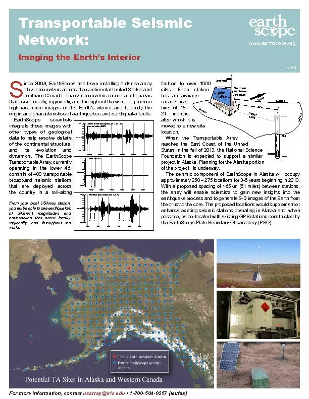
wwwearthscopeorgFor more information contact usarrayirisedu x2022 18005040357 telfaxv1011ince 2003 EarthScope has been installing a dense array of seismometers across the continental Un ID: 447586

www.earthscope.orgFor more information contact usarray@iris.edu

Share:

Link:

Embed:

Download Presentation from below link

Download Pdf The PPT/PDF document "Transportable SeismicNetwork:Imaging the..." is the property of its rightful owner. Permission is granted to download and print the materials on this web site for personal, non-commercial use only, and to display it on your personal computer provided you do not modify the materials and that you retain all copyright notices contained in the materials. By downloading content from our website, you accept the terms of this agreement.


Presentation Transcript

Transportable SeismicNetwork:Imaging the Earth’s Interior www.earthscope.orgFor more information, contact usarray@iris.edu • 1-800-504-0357 (tel/fax)v1011ince 2003, EarthScope has been installing a dense array of seismometers across the continental United States and southern Canada. The seismometers record earthquakes that occur locally, regionally, and throughout the world to produce high-resolution images of the Earth’s interior and to study the origin and characteristics of earthquakes and earthquake faults. EarthScope scientists integrate these images with other types of geological data to help resolve details of the continental structure, and its evolution and dynamics. The EarthScope Transportable Array, currently operating in the lower 48, consists of 400 transportable broadband seismic stations that are deployed across the country in a roll-along 00:30:00.000201125801:00:00.000201125801:30:00.000201125802:00:00.000201125802:30:00.000201125803:00:00.0002011258TOLK BHZ -310.0 nm/sec -300.0 -250.0 -200.0 -150.0 -100.0 -50.0 -10.0 0 20.0 50.0 100.0 150.0 200.0 250.0 Alaska Trench earthquakes, M ~ 3.2 - 4.2 vertical scale x 0.001 17:00:00.000201123217:30:00.000201123218:00:00.000201123218:30:00.000201123219:00:00.000201123219:30:00.0002011232TOLK BHZ -28000 nm/sec -25000 -20000 -15000 -10000 -5000 0 5000 10000 15000 20000 25000 30000 New Hebrides doublet, M = 7.0 , 7.2 P S R P S R 18:00:00.000201123618:30:00.000201123619:00:00.000201123619:30:00.000201123620:00:00.000201123620:30:00.0002011236TOLK BHZ -14000 nm/sec -10000 -5000 0 10000 15000 20000 Peru , M = 7.0 P S From your local USArray station, you will be able to see earthquakes of different magnitudes and earthquakes that occur locally, regionally, and throughout the world. fashion to over 1600 sites. Each station has an average residence time of 18-24 months, after which it is moved to a new site location. When the Transportable Array reaches the East Coast of the United States in the fall of 2013, the National Science Foundation is expected to support a similar project in Alaska. Planning for the Alaska portion of the project is underway.The seismic component of EarthScope in Alaska will occupy approximately 250 – 275 locations for 3-5 years beginning in 2013. With a proposed spacing of ~85km (51 miles) between stations, the array will enable scientists to gain new insights into the earthquake process and to generate 3-D images of the Earth from the crust to the core. The proposed locations would supplement or enhance existing seismic stations operating in Alaska and, when possible, be co-located with existing GPS stations constructed by the EarthScope Plate Boundary Observatory (PBO). SP ASS S SEaESCN Participating in EarthScope:Hosting a Transportable Seismic Station www.earthscope.orgv1011 EarthScope earthquake monitoring stations are constructed, operated, and maintained by the Incorporated Research Institutions for Seismology (IRIS) with funds from the National Science Foundation.For more information, contact usarray@iris.edu • 1-800-504-0357 (tel/fax)arthScope will be installing transportable seismic stations in Alaska and Canada to record earthquakes occurring locally, nationally, and worldwide. The data are used to produce images of the Earth’s interior and provide new insights into the earthquake process. EarthScope is seeking participation from federal and state agencies as well as Native Corporations to accomplish this university-based research experiment. Respect the property and privacy of landowners throughout the experiment, notifying the landowner whenever access is required.Be responsible for the security and operation of the station.Assume liability if the equipment is damaged or stolen, remain responsible for any damage done to the landowner’s property, and hold the landowner harmless for any loss or injury.Remove the equipment completely after the experiment.Provide the landowner with updates about the project and sample recordings from their station.EarthScope will:Seismic Station Speci�cationsInstallation and MaintenanceTransportable seismic stations have a low pro�le – there is no noise or motion associated with the equipment. To reduce interference from surface vibrations and to protect the equipment, the seismometer would be buried 10 to 20 feet below the ground inside an augered hole. Other sensor deployment methods are also being tested at this time. Power will be provided by solar panels mounted nearby on a pole or a hut and powered by a combination of battery and fuel cell systems. Cables are buried inside a conduit. Data are transmitted to the EarthScope data processing center via cellular, broadband, or satellite communication systems. When a satellite system is used, the 3-foot dish and an enclosure with electronics would be located nearby, or it could be located near power and linked by radio to the seismic station. The equipment can also be painted to blend in with the surroundings. The station installation footprint is anticipated to be approximately 10 feet by 20 feet.Installation of an EarthScope transportable seismic station usually takes 3 days. An extra day is occasionally required for testing and reconditioning the landscape. The buried sensor equipment is heavily insulated. The seismic stations are temporary, remaining in place for less than �ve years. The equipment operates continuously and routine maintenance is performed remotely. If the equipment malfunctions, it is detected at the data processing center and a service trip may be necessary to correct the problem. Earthscope in Alaska: Seismichttp://www.giseis.alaska.edu/earthscope/earthscope.htmlEarthscope Science Plan: 2010 to 2020http://earthscope.org/ESSPEarthscope: USArrayhttp://earthscope.org/observatories/usarrayNational Park Service and Earthscopehttp://www.nature.nps.gov/geology/earthscope/ Big Science: Earthscope, The Universe’s Most Epic Projecthttp://www.popsci.com/science/gallery/2011-07/big-science-universes-ten-most-epic-projects?image=E Relevant Links: University of Alaska FairbanksGEOPHYSICAL INSTITUTE