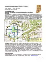
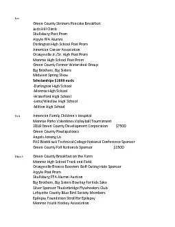
/
Cedar Bluffs Nature Preserve County Monroe Size  acres Cedar Bluffs Nature Preserve County Monroe Size  acres

Cedar Bluffs Nature Preserve County Monroe Size acres - PDF document

luanne-stotts
luanne-stotts . @luanne-stotts
Follow
468 views
Uploaded On 2015-04-08

Cedar Bluffs Nature Preserve County Monroe Size acres - PPT Presentation

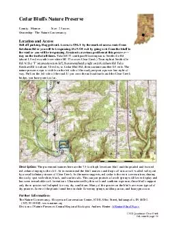
Rugged trail Access is ONLY by the marked access route from Ketcham Rd or you will be trespassing Do NOT exit by going west from the bluff to the road or you will be trespassing Erosion is a serious problem at this preserve stay on the trail at all ID: 49661

Rugged trail Access

Share:

Link:

Embed:

Download Presentation from below link

Download Pdf The PPT/PDF document "Cedar Bluffs Nature Preserve County Monr..." is the property of its rightful owner. Permission is granted to download and print the materials on this web site for personal, non-commercial use only, and to display it on your personal computer provided you do not modify the materials and that you retain all copyright notices contained in the materials. By downloading content from our website, you accept the terms of this agreement.


Presentation Transcript

Cedar Bluffs Nature Preserve County: Monroe Size: 23 acres Ownership: The Nature Conservancy Location and Access Pull - off parking. Rugged trail. Access is ONLY by the marked access route from Ketcham Rd or you will be trespassing. Do NOT exit by going west from the bluff to the road or you will be trespassing. Erosion is a serious problem at this preserve — stay on the trail at all times. Take SR 37 south past Bloomington to Smithville Rd (about 1.9 mi les south from where SR 37 crosses Clear Creek). Turn right at Smithville Rd. At the ‘T’ intersection turn left, then immediately right onto Ketcham Rd. Take Ketcham Rd for about 3.0 mi les , to Cedar Bluff Rd, then continue another 0.5 mi le . The nature preserve sign is visible on the left side of the road, just past a power line right - of - way. Park on the left side of the road. If you cross the railroad tracks and the Clear Creek bridge, you have gone too far. Description: The prominent features here are the 75 - foot high limestone bluff and the gnarled and twisted red cedars clinging to the cliff. At its eastern end the bluff narrows and drops off into a rock - walled valley cut by a small tributary stream of Clear Creek. As the name suggests, red cedar is the most common tree, sharing this rocky spot with white, black, and scarlet oaks. This canyon protects a lavish spring wildflower display and has some remarkable rock formations. Characterized by thin soils and southern exposure, these bluffs support only those species well - adapted for very dry conditions. Many of the species on the bluffs are more typical of dry prairies. Some of the plants found here include flowering spurge, nodding onion, and hoary puccoo n. Further Information: The Nature Conservancy. Efroymson Conservation Center, 62 0 E. Ohio Street, Indianapolis , IN 46202. ( 317 ) 951 - 8818. www.nature.org Division of Nature Preserves Central Regional Ecologist , Andrew Reuter : AReuter @dnr. IN .gov USGS Quad map: Clear Creek DeLorme ® page: 50 ●