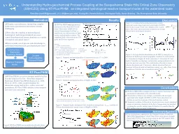
Using RTFluxPIHM an integrated hydrologicalreactive transport model at the watershed scale Chen Bao cub200psuedu Li Li lili emepsuedu Yuning Shi Pamela Sullivan Christopher ID: 801107
Download The PPT/PDF document "Understanding Hydro-geochemical Process ..." is the property of its rightful owner. Permission is granted to download and print the materials on this web site for personal, non-commercial use only, and to display it on your personal computer provided you do not modify the materials and that you retain all copyright notices contained in the materials. By downloading content from our website, you accept the terms of this agreement.
Slide1
Understanding Hydro-geochemical Process Coupling at the Susquehanna Shale Hills Critical Zone Observatory (SSHCZO
) Using RT-Flux-PIHM: an integrated hydrological-reactive transport model at the watershed scale
Chen Bao (cub200@psu.edu), Li Li (
lili@
eme.psu.edu), Yuning Shi, Pamela Sullivan, Christopher Duffy, Susan Brantley. The Pennsylvania State University
d
Conclusions
Results
Despite recent advances,
interpreting complex
hydro-
meteo
-geochemical interactions
remains
challenging.
How
does the coupling of
meteorological, hydrological, and (bio)geochemical processes control
dissolution and stream chemistry at a variety of temporal and spatial scales? How to make use of process scale knowledge to understand watershed scale geochemical processes?
Motivation
RT-Flux
-
PIHM
is a reactive transport module that
has been developed on the Flux - Penn State Integrated Hydrologic Model (Flux-PIHM) (Kumar et al., 2008, Shi et al., 2013), a fully coupled simulator for interactions among land surface, surface water, and groundwater. RT-Flux-PIHM simulates solute transport and water-rock interactions.
RT-Flux-PIHM
Acknowledgement
RT-Flux-PIHM
offers a unique interface to explore hydrologic
and
geochemical interactions at the watershed scale.
Dissolution of chlorite was strongly correlated to the averaged equivalent water height (AEWH) in
2009. Faster dissolution of chlorite occurred in locations of elevated moisture content. Temporal evolution of chloride in stream water was closely simulated using real rainwater chemistry while that of magnesium was matched by tuning the specific surface area of chlorite to be smaller than the BET surface area measured in laboratory.
This research was supported by the National Science Foundation Shale Hills-Susquehanna Critical Zone Observatory project through Grant EAR 0725019. Data were provided by the NSF funded Shale Hill Susquehanna Critical Zone Observatory.
Discussion
Land surface + Watershed hydrology Models
Reactive Transport Model
Coupled
Hydro-
Reactive Transport Model
Figure 2.
Temporal and spatial profiles of conservative tracer Cl
-
in 2009.
Figure 3.
Temporal and spatial profiles of Mg(II)
in 2009.
Figure 4. Temporal (right) and spatial (left: watershed averaged rate ) profiles of Chlorite dissolution rates (major source of Mg(II) in 2009).
Figure 5
. Correlations between dissolution rates, stream magnesium and averaged equivalent water height (AEWH), which is the average of total water height in meter in grid blocks.
Pore water and stream water chemistry was strongly affected by the hydrological dynamics.
Figure 6. Average chlorite dissolution rate in 2009 (μ mol/g/d) as a functions of hydrological and topographic condition in each location (A: Groundwater height; B: Water saturation; C: Elevation; D: Soil depth). Generally on ridgetops, soil moisture and groundwater levels were low and soil were thin. This combination often led to slower chlorite dissolution rate. Conversely, chlorite dissolved faster in locations with an elevated soil moisture content, e.g. valley floor. Faster dissolution of chlorite also occurred at swales (Fig 5).
Chlorite dissolves faster in swales
Stream water sampling point
Notations:
V
i
= volume of control volume
N_block
= number of grid blocks;
C
n
mineral_j
,
i
= concentration of mineral species
MW
j
=
molar weight of mineral species
A
i
=
the area of the triangular element
h
u
= the equivalent water height in unsaturated zone
h
g
= groundwater water height.
*: The major source of chloride is from rain water (
rain
chemistry from NADP, PA42
).
*
: Prescribed chlorite specific surface area of 0.15 m2/g, which is smaller than laboratory derived values (~1m2/g)
Figure1
. RT-Flux-PIHM uses an unstructured mesh where hydrogeochemical processes are realized within each grid.
RT-Flux-PIHM
was
implemented and tested at the Shale Hill Critical Zone Observatory (SSHCZO) in central Pennsylvania (0.08 km
2), a small-scale site with an array of land-surface and subsurface sensors. The simulated field is discretized into 535 grids and 20 river segments.
Reaction list and notations:
i: grid cell?j: mineral species n: times step